Tập tin:Maldives.visibleearth.nasa.jpg

Kích thước hình xem trước: 466×599 điểm ảnh. Độ phân giải khác: 187×240 điểm ảnh | 373×480 điểm ảnh | 597×768 điểm ảnh | 796×1.024 điểm ảnh | 1.400×1.800 điểm ảnh.
Tập tin gốc (1.400×1.800 điểm ảnh, kích thước tập tin: 530 kB, kiểu MIME: image/jpeg)
 | This map has been uploaded by Electionworld from en.wikipedia.org to enable the |
Miêu tả
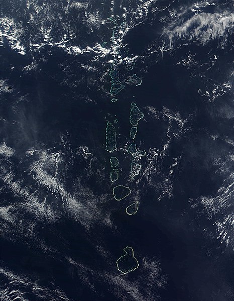
Source: http://visibleearth.nasa.gov
It should be noted that the southern most Atoll of the Maldives, Addu Atoll, is not visible on this image.
Giấy phép
| This file is in the public domain in the United States because it was solely created by NASA. NASA copyright policy states that "NASA material is not protected by copyright unless noted". (See Template:PD-USGov, NASA copyright policy page or JPL Image Use Policy.) | ||
 | Warnings:
|
Lịch sử tập tin
Nhấn vào ngày/giờ để xem nội dung tập tin tại thời điểm đó.
| Ngày/giờ | Hình xem trước | Kích cỡ | Thành viên | Miêu tả | |
|---|---|---|---|---|---|
| hiện tại | 22:52, ngày 27 tháng 11 năm 2006 | | 1.400×1.800 (530 kB) | Electionworld | {{ew|en|Oblivious}} == Summary == '''Source:''' [http://veimages.gsfc.nasa.gov/2686/Maldives.A2002090.0525.500m.jpg http://visibleearth.nasa.gov] It should be noted that the southern most Atoll of the Maldives, Addu Atoll, is not visible on this ima |
Trang sử dụng tập tin
Có 1 trang tại Wikipedia tiếng Việt có liên kết đến tập tin (không hiển thị trang ở các dự án khác):
Sử dụng tập tin toàn cục
Những wiki sau đang sử dụng tập tin này:
- Trang sử dụng tại af.wikipedia.org
- Trang sử dụng tại ar.wikipedia.org
- Trang sử dụng tại en.wikipedia.org
- Trang sử dụng tại gl.wikipedia.org
- Trang sử dụng tại hi.wikipedia.org
- Trang sử dụng tại it.wikipedia.org
- Trang sử dụng tại kn.wikipedia.org
- Trang sử dụng tại lt.wikipedia.org
- Trang sử dụng tại mk.wikipedia.org
- Trang sử dụng tại ml.wikipedia.org
- Trang sử dụng tại my.wikipedia.org
- Trang sử dụng tại pl.wikipedia.org
- Trang sử dụng tại sd.wikipedia.org
- Trang sử dụng tại sr.wikipedia.org
- Trang sử dụng tại ta.wikipedia.org
- Trang sử dụng tại th.wikipedia.org
- Trang sử dụng tại trv.wikipedia.org
- Trang sử dụng tại tr.wikipedia.org
- Trang sử dụng tại uk.wikipedia.org
- Trang sử dụng tại zh.wikipedia.org
Đặc tính hình
🔥 Top keywords: Đài Truyền hình Kỹ thuật số VTCTrang ChínhGiỗ Tổ Hùng VươngTrương Mỹ LanĐặc biệt:Tìm kiếmHùng VươngVương Đình HuệUEFA Champions LeagueKuwaitChiến dịch Điện Biên PhủFacebookĐài Truyền hình Việt NamTrần Cẩm TúĐội tuyển bóng đá quốc gia KuwaitGoogle DịchViệt NamCúp bóng đá U-23 châu ÁCúp bóng đá U-23 châu Á 2024Real Madrid CFBảng xếp hạng bóng đá nam FIFACleopatra VIITô LâmTim CookNguyễn Phú TrọngHồ Chí MinhHai Bà TrưngManchester City F.C.VnExpressChủ tịch nước Cộng hòa xã hội chủ nghĩa Việt NamNguyễn Ngọc ThắngĐền HùngCúp bóng đá trong nhà châu Á 2024Võ Văn ThưởngOne PieceLịch sử Việt NamCuộc đua xe đạp toàn quốc tranh Cúp truyền hình Thành phố Hồ Chí Minh 2024Phạm Minh ChínhTikTokĐinh Tiên Hoàng