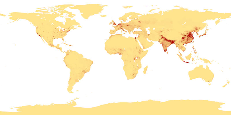
Tập tin:Population density.png

Kích thước hình xem trước: 800×400 điểm ảnh. Độ phân giải khác: 320×160 điểm ảnh | 640×320 điểm ảnh | 1.024×512 điểm ảnh | 1.280×640 điểm ảnh | 2.560×1.280 điểm ảnh | 4.320×2.160 điểm ảnh.
Tập tin gốc (4.320×2.160 điểm ảnh, kích thước tập tin: 522 kB, kiểu MIME: image/png)
Lịch sử tập tin
Nhấn vào ngày/giờ để xem nội dung tập tin tại thời điểm đó.
| Ngày/giờ | Hình xem trước | Kích cỡ | Thành viên | Miêu tả | |
|---|---|---|---|---|---|
| hiện tại | 00:41, ngày 11 tháng 4 năm 2013 |  | 4.320×2.160 (522 kB) | Jahoe | Re-downloaded original from http://eoimages.gsfc.nasa.gov/images/imagerecords/53000/53005/population_density.tif, re-converted to PNG (preserving alpha channel) using tiff2png (by Willem van Schaik and Greg Roelofs). Removed rgb pixel values from fully... |
| 03:41, ngày 27 tháng 2 năm 2007 |  | 4.320×2.160 (915 kB) | Keenan Pepper | This image shows the number of people per square kilometer around the world in 1994. The data were derived from population records based on political divisions such as states, provinces, and counties. The image was taken from [http://visibleearth.nasa.go |
Trang sử dụng tập tin
Có 3 trang tại Wikipedia tiếng Việt có liên kết đến tập tin (không hiển thị trang ở các dự án khác):
Sử dụng tập tin toàn cục
Những wiki sau đang sử dụng tập tin này:
- Trang sử dụng tại als.wikipedia.org
- Trang sử dụng tại an.wikipedia.org
- Trang sử dụng tại ar.wikipedia.org
- Trang sử dụng tại ast.wikipedia.org
- Trang sử dụng tại az.wikipedia.org
- Trang sử dụng tại be-tarask.wikipedia.org
- Trang sử dụng tại be.wikipedia.org
- Trang sử dụng tại bg.wikipedia.org
- Trang sử dụng tại bh.wikipedia.org
- Trang sử dụng tại bn.wikipedia.org
- Trang sử dụng tại bs.wikipedia.org
- Trang sử dụng tại ca.wikipedia.org
- Trang sử dụng tại ce.wikipedia.org
- Trang sử dụng tại ckb.wikipedia.org
- Trang sử dụng tại cu.wikipedia.org
- Trang sử dụng tại cv.wikipedia.org
- Trang sử dụng tại da.wikipedia.org
- Trang sử dụng tại da.wikibooks.org
- Trang sử dụng tại de.wikipedia.org
- Trang sử dụng tại dsb.wikipedia.org
- Trang sử dụng tại el.wikipedia.org
- Trang sử dụng tại en.wikipedia.org
- Trang sử dụng tại en.wikiquote.org
- Trang sử dụng tại eo.wikipedia.org
- Trang sử dụng tại es.wikipedia.org
Xem thêm các trang toàn cục sử dụng tập tin này.
🔥 Top keywords: Đài Truyền hình Kỹ thuật số VTCTrang ChínhGiỗ Tổ Hùng VươngTrương Mỹ LanĐặc biệt:Tìm kiếmHùng VươngVương Đình HuệUEFA Champions LeagueKuwaitChiến dịch Điện Biên PhủFacebookĐài Truyền hình Việt NamTrần Cẩm TúĐội tuyển bóng đá quốc gia KuwaitGoogle DịchViệt NamCúp bóng đá U-23 châu ÁCúp bóng đá U-23 châu Á 2024Real Madrid CFBảng xếp hạng bóng đá nam FIFACleopatra VIITô LâmTim CookNguyễn Phú TrọngHồ Chí MinhHai Bà TrưngManchester City F.C.VnExpressChủ tịch nước Cộng hòa xã hội chủ nghĩa Việt NamNguyễn Ngọc ThắngĐền HùngCúp bóng đá trong nhà châu Á 2024Võ Văn ThưởngOne PieceLịch sử Việt NamCuộc đua xe đạp toàn quốc tranh Cúp truyền hình Thành phố Hồ Chí Minh 2024Phạm Minh ChínhTikTokĐinh Tiên Hoàng


