خیخن
خیخن (ایسپانجا: Gijón) ایسپانیادا بیر یاشاییش منطقهسیدیر ۳ متر دنیز سویهسیندن اۇجالیقی وار. بۇ شهرین مساحتی ۱۸۱٫۶ کیلومتر موربّع دیر. سوْن نۆفوس تخمینلرینه گؤره ۲۷۲۳۶۵ نفر دیر.
Gijón
| |
|---|---|
Municipality | |
| Gijón / Xixón [۱] | |
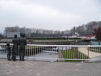
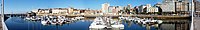
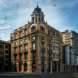
 Top:View of Santa Catalina Hills (Cerro de Santa Catalina), 2nd row:Revillagigedo Palace and Don Pelayo Statue (left), San Pedro Church (right), 3rd row:A office area in Munuza Street, 4th row:Cimadevilla area and San Juan Bautista, Bottom:Twilight view of El Musel Port | |
 بایراق  نیشان | |
 Location of Gijón | |
 Gijón Location in Spain | |
| موختصاتلار: 43°32′N 5°42′W / 43.533°N 5.700°W 5°42′W / 43.533°N 5.700°W | |
| Country | |
| Autonomous community | |
| ایسپانیا اوستانلاری | Asturias |
| Comarca | Gijón |
| Judicial district | Gijón |
| Founded | 5th century BC (Noega, the first settlement on record) |
| اراضی | |
| • جمع | ۱۸۱٫۶ km2 (۷۰٫۱ sq mi) |
| اوجالیق | ۳ m (۱۰ ft) |
| لاپ اوجا یئری | ۷۳۷ m (۲٬۴۱۸ ft) |
| لاپ چوخور یئری | ۰ m (۰ ft) |
| جمعیت (2017) | |
| • جمع | ۲۷۲٬۳۶۵ |
| • سیخلیق | ۱٬۵۰۰/km2 (۳٬۹۰۰/sq mi) |
| دمونیم | gijonés, -esa (ایسپانیا دیلی) xixonés, -esa (آستورییا دیلی) |
گؤرونتولر

-


-
-


- فایل:GijónBici.png


.PNG)


بیرده باخ
قایناقلار
ایسپانیا ویکیپدیاسینین ایشلدنلری طرفیندن یارانمیش«Gijón»، مقالهسیندن گؤتورولوبدور.( ۷ مارس ۲۰۱۸ تاریخینده یوْخلانیلیبدیر).
| Population of Gijón | ||
|---|---|---|
| Year | Pop. | ±% p.a. |
| 1857 | ۲۳٬۶۲۱ | — |
| 1860 | ۲۴٬۸۰۲ | +1.64% |
| 1877 | ۳۰٬۵۹۱ | +1.24% |
| 1887 | ۳۵٬۱۷۰ | +1.40% |
| 1897 | ۴۳٬۳۹۲ | +2.12% |
| 1900 | ۴۵٬۵۴۴ | +1.63% |
| 1910 | ۵۵٬۲۴۸ | +1.95% |
| 1920 | ۵۷٬۵۷۳ | +0.41% |
| 1930 | ۷۸٬۲۳۹ | +3.11% |
| 1940 | ۱۰۱٬۳۴۱ | +2.62% |
| 1950 | ۱۱۰٬۹۸۵ | +0.91% |
| 1960 | ۱۲۴٬۷۱۴ | +1.17% |
| 1970 | ۱۸۷٬۶۱۲ | +4.17% |
| 1981 | ۲۵۵٬۹۶۹ | +2.86% |
| 1991 | ۲۶۰٬۲۶۷ | +0.17% |
| 1998 | ۲۶۵٬۴۹۱ | +0.28% |
| 1999 | ۲۶۷٬۹۸۰ | +0.94% |
| 2000 | ۲۶۷٬۴۲۶ | −0.21% |
| 2001 | ۲۶۹٬۲۷۰ | +0.69% |
| 2002 | ۲۷۰٬۲۱۱ | +0.35% |
| 2003 | ۲۷۰٬۸۷۵ | +0.25% |
| 2004 | ۲۷۱٬۰۳۹ | +0.06% |
| 2005 | ۲۷۳٬۹۳۱ | +1.07% |
| 2006 | ۲۷۴٬۴۷۲ | +0.20% |
| 2007 | ۲۷۴٬۰۳۷ | −0.16% |
| 2008 | ۲۷۵٬۶۹۹ | +0.61% |
| 2009 | ۲۷۷٬۵۵۴ | +0.67% |
| 2010 | ۲۷۷٬۱۹۸ | −0.13% |
| 2011 | ۲۷۷٬۵۵۹ | +0.13% |
| 2012 | ۲۷۷٬۷۳۳ | +0.06% |
| 2013 | ۲۷۵٬۲۷۴ | −0.89% |
| 2014 | ۲۷۵٬۷۳۵ | +0.17% |
| 2015 | ۲۷۶٬۴۷۳ | +0.27% |
| 2016 | ۲۷۶٬۰۰۱ | −0.17% |
| 2017 | ۲۷۲٬۳۶۵ | −1.32% |
| From 1998 to present, population as of each January 1st Source: INE | ||
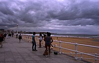
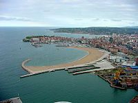
The city is situated on the coast of central Asturias, from sea level to an altitude of 513 metres at Picu Samartín and 672 metres at Peña de los Cuatro Jueces, bordered on the West by Carreño, the East by بیابیسیوسا, and to the South by سیرو (آستوریاس) and LlaneraThe city is situated along the Asturian coast and is distinguished by the peninsula of Cimavilla (the original settlement) which separates the beach of San Lorenzo and adjacent neighbourhoods to the east from the beaches of Poniente and Arbeyal, the shipyards, and the recreational port and the Port of El Musel to the west. It is close to the other main Asturian cities, ابیدو and آبیلس.
Climate
Gijón has a temperate oceanic climate[۱] typical of the Atlantic coast of Spain, with cool summers and wet and mostly mild winters. The onshore flow from the Atlantic Ocean creates a cool summer and mild winter climate where severe heat and very cold temperatures are rare. The narrow temperature range is demonstrated by the record August temperature being only 6.4 °C warmer than the all-time record January temperature.[۲] The climate is wet and cloudy by Spanish standards, but is indeed drier than other locations on the Atlantic in the country. Humidity is high year-round.
| دادههای اقلیم Gijón (1971–2000) | |||||||||||||
|---|---|---|---|---|---|---|---|---|---|---|---|---|---|
| آی | ژانویه | فوریه | مارس | آوریل | مه | ژوئن | ژوئیه | اوت | سپتامبر | اکتبر | نوامبر | دسامبر | ایل |
| سابقهٔ بیشترین °C (°F) | 23.6 (74.5) | 23.0 (73.4) | 27.0 (80.6) | 28.0 (82.4) | 31.8 (89.2) | 36.4 (97.5) | 31.4 (88.5) | 30.0 (86) | 34.6 (94.3) | 30.4 (86.7) | 26.1 (79) | 25.0 (77) | 36.4 (97.5) |
| میانگین بیشترین °C (°F) | 13.1 (55.6) | 13.8 (56.8) | 14.9 (58.8) | 15.6 (60.1) | 17.8 (64) | 20.2 (68.4) | 22.4 (72.3) | 23.2 (73.8) | 21.8 (71.2) | 19.0 (66.2) | 15.6 (60.1) | 14.0 (57.2) | 17.6 (63.7) |
| میانگین روزانه °C (°F) | 8.9 (48) | 9.6 (49.3) | 10.7 (51.3) | 11.8 (53.2) | 14.3 (57.7) | 16.9 (62.4) | 19.2 (66.6) | 19.7 (67.5) | 17.9 (64.2) | 15.0 (59) | 11.6 (52.9) | 9.9 (49.8) | 13.8 (56.8) |
| میانگین کمترین °C (°F) | 4.7 (40.5) | 5.4 (41.7) | 6.6 (43.9) | 8.1 (46.6) | 10.9 (51.6) | 13.6 (56.5) | 16.0 (60.8) | 16.2 (61.2) | 14.1 (57.4) | 11.0 (51.8) | 7.6 (45.7) | 5.8 (42.4) | 10.0 (50) |
| سابقهٔ کمترین °C (°F) | −4.6 (23.7) | −4.0 (24.8) | −2.0 (28.4) | 0.4 (32.7) | 3.2 (37.8) | 5.8 (42.4) | 8.6 (47.5) | 8.2 (46.8) | 5.0 (41) | 2.6 (36.7) | −1.4 (29.5) | −4.8 (23.4) | −4.8 (23.4) |
| بارندگی میلیمتر (اینچ) | 94 (3.7) | 85 (3.35) | 74 (2.91) | 93 (3.66) | 79 (3.11) | 47 (1.85) | 45 (1.77) | 54 (2.13) | 70 (2.76) | 104 (4.09) | 120 (4.72) | 104 (4.09) | 971 (38.23) |
| میانگین روزهای بارندگی (≥ ۱ mm) | 12 | 11 | 10 | 12 | 11 | 7 | 6 | 7 | 8 | 11 | 12 | 12 | 121 |
| میانگین روزانه ساعتهای تابش آفتاب | 103 | 109 | 137 | 151 | 167 | 180 | 194 | 190 | 158 | 132 | 106 | 92 | ۱٬۷۲۱ |
| منبع: Agencia Estatal de Meteorología[۳] | |||||||||||||
| دادههای اقلیم Gijón urban center (2002-2016) | |||||||||||||
|---|---|---|---|---|---|---|---|---|---|---|---|---|---|
| آی | ژانویه | فوریه | مارس | آوریل | مه | ژوئن | ژوئیه | اوت | سپتامبر | اکتبر | نوامبر | دسامبر | ایل |
| میانگین بیشترین °C (°F) | 13.2 (55.8) | 13.6 (56.5) | 14.8 (58.6) | 16.0 (60.8) | 17.8 (64) | 20.6 (69.1) | 22.6 (72.7) | 23.2 (73.8) | 21.9 (71.4) | 19.8 (67.6) | 16.2 (61.2) | 14.6 (58.3) | 17.8 (64) |
| میانگین روزانه °C (°F) | 10.4 (50.7) | 10.3 (50.5) | 11.6 (52.9) | 13.0 (55.4) | 15.0 (59) | 17.9 (64.2) | 19.8 (67.6) | 20.4 (68.7) | 19.0 (66.2) | 16.6 (61.9) | 13.1 (55.6) | 11.3 (52.3) | 14.8 (58.6) |
| میانگین کمترین °C (°F) | 7.6 (45.7) | 7.0 (44.6) | 8.4 (47.1) | 10.1 (50.2) | 12.1 (53.8) | 15.2 (59.4) | 17.1 (62.8) | 17.5 (63.5) | 16.0 (60.8) | 13.4 (56.1) | 10.1 (50.2) | 8.0 (46.4) | 11.8 (53.2) |
| بارندگی میلیمتر (اینچ) | 113.2 (4.457) | 97.8 (3.85) | 87.0 (3.425) | 80.6 (3.173) | 63.6 (2.504) | 57.1 (2.248) | 32.1 (1.264) | 43.2 (1.701) | 49.1 (1.933) | 88.8 (3.496) | 131.5 (5.177) | 100.9 (3.972) | 944.9 (37.201) |
| منبع: Météo Climat[۴] | |||||||||||||
| Type | Name | Alternate name | Itinerary |
|---|---|---|---|
| Highway | Invalid type: A | Autovía del Cantábrico | Baamonde – Gijón – Llanes – تورلاوقا – Solares – بیلبائو – سن سباستین |
| Invalid type: A | Autovía Ruta de la Plata | Gijón – ابیدو – میرس، آستوریاس – لئون (ایسپانیا) – Benavente – سامرا (ایسپانیا) – سالامانکا – Béjar – پلاسنسیا – مریدا – آلمندرالخو – سویا (شهر) | |
| AS-I | Autovía Minera | Gijón – Pola de Siero – لانقرئو – میرس، آستوریاس | |
| AS-II | Autovía Industrial | Gijón – Lugo de Llanera – ابیدو | |
| GJ-10 | Interior ring road | Gijón seaport (El Musel) – Pumarín – El Llano | |
| GJ-20 | Western ring road | GJ-81 (Autopista Acceso Sur a Gijón) – Tremañes – Gijón seaport (El Musel) | |
| GJ-8 | South access road | (A-8/A-66) – Plaza del Humedal | |
| National road | N-630 | Gijón – ابیدو – میرس، آستوریاس – Puerto de Pajares – لئون (ایسپانیا) – سامرا (ایسپانیا) – سالامانکا – پلاسنسیا – مریدا – آلمندرالخو – سویا (شهر) | |
| N-632 | Cenero – Cudillero – Muros del Nalón – Soto del Barco – آبیلس – Gijón – بیابیسیوسا – Colunga – Caravia – ریبادسیا | ||
| N-641 | El Musel access Road | Gijón – La Calzada – Gijón seaport (El Musel) . | |
| Regional and local roads | AS-19 | Gijón-Avilés Road | Gijón – El Empalme – Prendes – Tabaza – آبیلس |
| AS-246 | Carbonera Road | Gijón – Alto de la Madera – Noreña – El Berrón – La Gargantada – لانقرئو | |
| AS-247 | Piles to Infanzón Road | Gijón – Somió – Alto del Infanzón | |
| AS-248 | Gijón-Siero Road | Gijón – Vega de Poja – Pola de Siero | |
| AS-266 | Oviedo-Gijón Road | ابیدو – Lugones – Pruvia – Porceyo – Gijón | |
| AS-19a | Gijón-Avilés Road | Puenteseco – Muniello |
| Political party | 1979 | 1983 | 1987 | 1991 | 1995 | 1999 | 2003 | 2007 | 2011 | 2015 |
|---|---|---|---|---|---|---|---|---|---|---|
| PSOE | 13 | 17 | 11 | 12 | 12 | 16 | 13 | 13 | 10 | 7 |
| FAC | 9 | 8 | ||||||||
| Xixón Sí Puede | 6 | |||||||||
| AP / PP | 1 | 7 | 7 | 9 | 11 | 9 | 11 | 12 | 5 | 3 |
| IU | 4 | 3 | 3 | 3 | 4 | 2 | 3 | 2 | 3 | 2 |
| UCD / CDS | 9 | 6 | ||||||||
| UGJ | 3 | |||||||||
| C's | 1 |
| Name | Start | End | Party |
|---|---|---|---|
| José Manuel Palacio | 1979 | 1987 | FSA-PSOE |
| Vicente Álvarez Areces | 1987 | 1999 | FSA-PSOE |
| Paz Fernández Felgueroso | 1999 | 2011 | FSA-PSOE |
| Carmen Moriyón | 2011 | FAC |
External links
| ویکیدولانمانین خیخن اوچون بیر سیاحت تعلیماتی وار. |