Fil:Kingdom of France 1000.svg

Size of this PNG preview of this SVG file: 485 × 340 pixels. Andre opløsninger: 320 × 224 pixels | 640 × 449 pixels | 1.024 × 718 pixels | 1.280 × 897 pixels | 2.560 × 1.795 pixels.
Fuld opløsning (SVG fil, basisstørrelse 485 × 340 pixels, filstørrelse: 1,22 MB)
| | Denne fil er fra Wikimedia Commons. Beskrivelsen af filen fra Commons er gengivet nedenfor. |
Beskrivelse
Vektorgrafikken blev lavet med Inkscape. .


.svg)
.svg)
.svg)
.svg)
.svg)


.svg)
.svg)
.svg)


.png)
.png)


.svg)


.svg)

.svg)


.svg)
.svg)
.svg)
.svg)


.svg)
.png)


.svg)


.svg)
.svg)


.svg)


.svg)


.svg)
.svg)
.svg)
.svg)
.svg)
.svg)
.svg)
.svg)
_cropped.svg)
.svg)
.svg)
.svg)
.svg)
.svg)
.svg)
.svg)
.svg)
.svg)
.svg)
.svg)
.svg)
.svg)
.svg)
.svg)
.svg)
.svg)
.svg)
.svg)
.svg)
.svg)
.svg)
.svg)
.svg)
.svg)
.svg)
.svg)
.svg)
.svg)
.svg)
.svg)
.svg)
.svg)
.svg)
.svg)
.svg)
.svg)
.svg)
.svg)
.svg)
.svg)
.svg)
.svg)
.svg)
.svg)
Licensering
This file is licensed under the Creative Commons Attribution-Share Alike 4.0 International license.
- Du må frit:
- at dele – at kopiere, distribuere og overføre værket
- at remixe – at tilpasse værket
- Under følgende vilkår:
- kreditering – Du skal give passende kreditering, angive et link til licensen, og oplyse om der er foretaget ændringer. Du må gøre det på enhver fornuftig måde, men ikke på en måde der antyder at licensgiveren godkender dig eller din anvendelse.
- deling på samme vilkår – Hvis du bearbejder, ændrer eller bygger videre på dette værk, skal du distribuere dine bidrag under den samme eller en kompatibel licens som originalen.
Filhistorik
Klik på en dato/tid for at se filen som den så ud på det tidspunkt.
| Dato/tid | Miniaturebillede | Dimensioner | Bruger | Kommentar | |
|---|---|---|---|---|---|
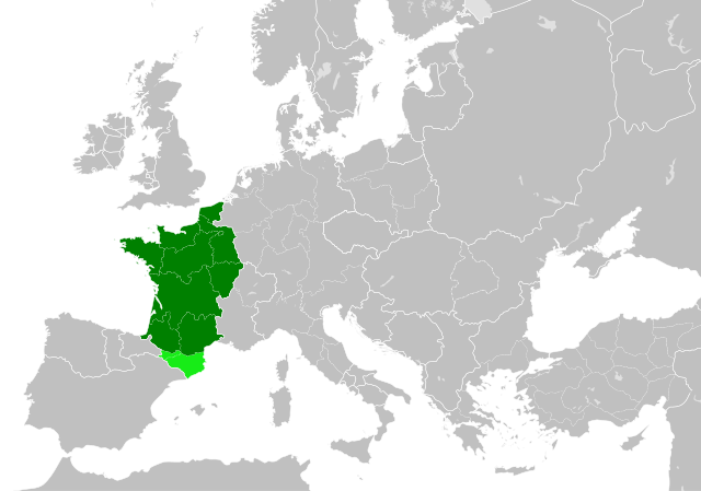
| nuværende | 20. jul. 2023, 00:55 | | 485 × 340 (1,22 MB) | Wario2 | The counties of Barcelona and Aragon were autonomous (de facto independent) and not an integral part of the realm) |
| 23. maj 2016, 18:22 |  | 485 × 340 (1,25 MB) | Alphathon | Corrected Flanders and incorporated some islands into their respective counties/duchies | |
| 23. maj 2016, 16:41 |  | 485 × 340 (1,25 MB) | Alphathon | Corrected status of Bohemia | |
| 22. maj 2016, 20:13 |  | 485 × 340 (1,23 MB) | Alphathon | Split Capua from Benevento and removed both from HRE, along with Spoleto | |
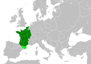
| 22. maj 2016, 18:46 |  | 485 × 340 (1,24 MB) | Alphathon | == {{int:filedesc}} == {{Inkscape}} {{Information |Description={{en|A map of the en:Kingdom of France within Europe circa 1000 CE. The main subdivisions of the Byzantine Empire, Holy Roman Empire, Burgundy, France and Poland are also shown.}} |So... |
Filanvendelse
Den følgende side bruger denne fil:
Global filanvendelse
Følgende andre wikier anvender denne fil:
- Anvendelser på arz.wikipedia.org
- Anvendelser på cs.wikipedia.org
- Anvendelser på en.wikipedia.org
- Anvendelser på es.wikipedia.org
- Anvendelser på fa.wikipedia.org
- Anvendelser på he.wikipedia.org
- Anvendelser på it.wikipedia.org
- Anvendelser på ko.wikipedia.org
- Anvendelser på mn.wikipedia.org
- Anvendelser på nrm.wikipedia.org
- Anvendelser på simple.wikipedia.org
- Anvendelser på sl.wikipedia.org
- Anvendelser på th.wikipedia.org
- Anvendelser på tr.wikipedia.org
- Anvendelser på uk.wikipedia.org
- Anvendelser på ur.wikipedia.org
- Anvendelser på vi.wikipedia.org
- Anvendelser på www.wikidata.org
- Anvendelser på zh.wikipedia.org
Metadata
.svg)
🔥 Top keywords: ForsideSpeciel:SøgningNy KaledonienUlla TerkelsenNaum ConevskiPinseSpeciel:Seneste ændringerRobert FicoSlovakietDagmar OverbySuperligaenDrabet på Emilie MengPeter LundinKaren ThistedBrad PittStjernetegnRasmus HøjlundDanmarkCarla MickelborgPalle SørensenVictoria Carmen SonneMarcel Lychau HansenKevin SpaceyN.F.S. GrundtvigStor gedehamsEurovision Song Contest 2024Danmarksmesterskab (fodbold)Odense BoldklubFrançois DuvalierTaylor SwiftDag HammarskjöldKøbenhavnNathalie zu Sayn-Wittgenstein-BerleburgFrederik 10.Kleopatra 7.BørsenJulie ØlgaardJacob NeestrupFC Midtjylland