Corozal barrio-pueblo is an urban barrio and the administrative center (seat) of Corozal, a municipality of Puerto Rico. Its population in 2010 was 2,631.[1][4]
Corozal barrio-pueblo Pueblo de Corozal | |
|---|---|
Municipality Seat[1] | |
.jpg) Main square with the Corozal city hall in the center | |
 Location of Corozal barrio-pueblo within the municipality of Corozal shown in red | |
 Corozal barrio-pueblo Location of Puerto Rico | |
| Coordinates: 18°20′23″N 66°19′00″W / 18.3397382°N 66.3167536°W[2] | |
| Commonwealth | |
| Municipality | |
| Area | |
| • Total | .352 sq mi (0.91 km2) |
| • Land | .352 sq mi (0.91 km2) |
| • Water | 0 sq mi (0 km2) |
| Elevation | 262 ft (80 m) |
| Population (2010) | |
| • Total | 2,631 |
| • Density | 7,517.1/sq mi (2,902.4/km2) |
| Source: 2010 Census | |
| Time zone | UTC−4 (AST) |
As was customary in Spain, in Puerto Rico, the municipality has a pueblo which contains a central plaza, the municipal buildings (city hall), and a Catholic church. Fiestas patronales (patron saint festivals) are held in the central plaza every year.[5][6]
History
Corozal barrio-pueblo was in Spain's gazetteers[7] until Puerto Rico was ceded by Spain in the aftermath of the Spanish–American War under the terms of the Treaty of Paris of 1898 and became an unincorporated territory of the United States. In 1899, the United States Department of War conducted a census of Puerto Rico finding that the population of Corozal barrio-pueblo (Pueblo) was 1,057.[8]
Features and demographics
Corozal barrio-pueblo has .352 square miles (0.91 km2) of land area and no water area. In 2010, its population was 2,631 with a population density of 7,517.1 inhabitants per square mile (2,902.4/km2).[9]
| Census | Pop. | Note | %± |
|---|---|---|---|
| 1900 | 1,057 | — | |
| 1910 | 1,301 | 23.1% | |
| 1920 | 1,747 | 34.3% | |
| 1930 | 2,451 | 40.3% | |
| 1940 | 2,974 | 21.3% | |
| 1950 | 2,428 | −18.4% | |
| 1960 | 3,166 | 30.4% | |
| 1970 | 0 | −100.0% | |
| 1980 | 1,663 | — | |
| 1990 | 3,011 | 81.1% | |
| 2000 | 2,850 | −5.3% | |
| 2010 | 2,631 | −7.7% | |
| U.S. Decennial Census 1899 (shown as 1900)[10] 1910-1930[11] 1930-1950[12] 1980-2000[13] 2010[14] | |||
The central plaza and its church
The central plaza, or square, is a place for official and unofficial recreational events and a place where people can gather and socialize from dusk to dawn. The Laws of the Indies, Spanish law, which regulated life in Puerto Rico in the early 19th century, stated the plaza's purpose was for "the parties" (celebrations, festivities) (Spanish: a propósito para las fiestas), and that the square should be proportionally large enough for the number of neighbors (Spanish: grandeza proporcionada alnúmero de vecinos). These Spanish regulations also stated that the streets nearby should be comfortable portals for passersby, protecting them from the elements: sun and rain.[5]
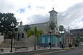
Located across the central plaza in Corozal barrio-pueblo is the Parroquia La Sagrada Familia, a Roman Catholic church.[15]
Sectors
Barrios (which are, in contemporary times, roughly comparable to minor civil divisions)[16] in turn are further subdivided into smaller local populated place areas/units called sectores (sectors in English). The types of sectores may vary, from normally sector to urbanización to reparto to barriada to residencial, among others.[17][18][19]
The following sectors are in Corozal barrio-pueblo:[20]
Barriada Aldea Vázquez,Barriada Bou,Calle Carmelo Aponte,Calle Cervantes,Calle Colegio Católico,Calle Culto,Calle Gándara,Calle Genaro Bou,Calle Howard T. Jason,Calle José Valiente,Calle La Marina,Calle Las Mercedes,Calle Nueva,Calle San Manuel,Calle Urbano Ramírez,Calle Santo Domingo,Calle Sostre,Calle San Ramón,Desvío Urbano,Extensión Sobrino,Residencial El Centro,Residencial Enrique Landrón,Sector Alcantarilla,Sector Alfonso Matos,Sector Cantera,Sector Portugués,Urbanización Sanfeliz, and Urbanización Sobrino.
Gallery
 Central plaza or square in Corozal pueblo
 Museo de la Barbería Barber museum
 Town hall in Corozal, in front of central plaza
 Square in Corozal pueblo
 Buildings around the square
 Parroquia La Sagrada Familia in Corozal pueblo
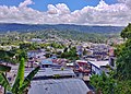 View of Corozal barrio-pueblo from Abras
.jpg)
.jpg)
.jpg)
.jpg)

.jpg)

See also

References
External links
 Media related to Corozal barrio-pueblo at Wikimedia Commons