Size of this preview: 800 × 401 pixels. Other resolutions: 320 × 160 pixels | 640 × 321 pixels | 1,024 × 513 pixels | 1,280 × 642 pixels | 3,000 × 1,504 pixels.
Original file (3,000 × 1,504 pixels, file size: 3.69 MB, MIME type: image/jpeg)
Summary
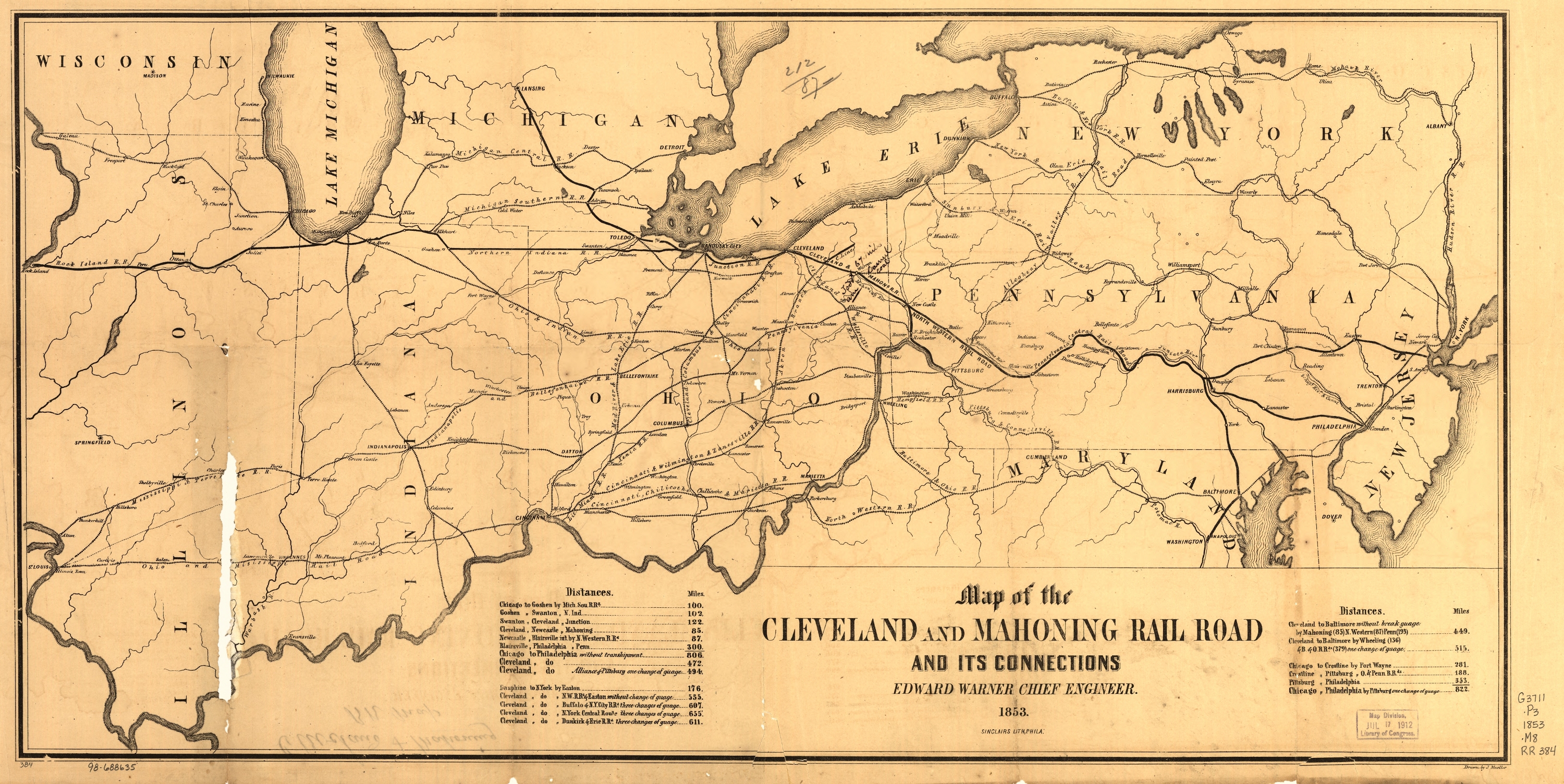
| Description | English: (From LOC) Sketch map of the north-central and middle Atlantic states showing the railroad network, major cities, rivers, and state boundaries. Tables of distances appear on both sides of title. Chartered on February 22, 1848.Resized and compressed. No other alterations. |
| Date | |
| Source | http://memory.loc.gov/cgi-bin/query/r?ammem/gmd:@filreq(@field(NUMBER+@band(rr003840))+@field(COLLID+rrmap)) |
| Author | John Mueller |
Licensing
This media file is in the public domain in the United States. This applies to U.S. works where the copyright has expired, often because its first publication occurred prior to January 1, 1929, and if not then due to lack of notice or renewal. See this page for further explanation. |  | |
 | This image might not be in the public domain outside of the United States; this especially applies in the countries and areas that do not apply the rule of the shorter term for US works, such as Canada, Mainland China (not Hong Kong or Macao), Germany, Mexico, and Switzerland. The creator and year of publication are essential information and must be provided. See Wikipedia:Public domain and Wikipedia:Copyrights for more details. |
File history
Click on a date/time to view the file as it appeared at that time.
| Date/Time | Thumbnail | Dimensions | User | Comment | |
|---|---|---|---|---|---|
| current | 21:40, 14 March 2010 | | 3,000 × 1,504 (3.69 MB) | Mackensen | {{Information |Description={{en|1=(From LOC) Sketch map of the north-central and middle Atlantic states showing the railroad network, major cities, rivers, and state boundaries. Tables of distances appear on both sides of title. Chartered on February 22, |
File usage
The following pages on the English Wikipedia use this file (pages on other projects are not listed):
Metadata
🔥 Top keywords: Main PageSpecial:SearchWikipedia:Featured picturesYasukeHarrison ButkerRobert FicoBridgertonCleopatraDeaths in 2024Joyce VincentXXXTentacionHank AdamsIt Ends with UsYouTubeNew Caledonia2024 Indian general electionHeeramandiDarren DutchyshenSlovakiaKingdom of the Planet of the ApesAttempted assassination of Robert FicoLawrence WongBaby ReindeerXXX: Return of Xander CageThelma HoustonFuriosa: A Mad Max SagaMegalopolis (film)Richard GaddKepler's SupernovaWicked (musical)Sunil ChhetriXXX (2002 film)Ashley MadisonAnya Taylor-JoyPlanet of the ApesNava MauYoung SheldonPortal:Current eventsX-Men '97