
Size of this PNG preview of this SVG file: 599 × 600 pixels. Other resolutions: 240 × 240 pixels | 479 × 480 pixels | 767 × 768 pixels | 1,022 × 1,024 pixels | 2,045 × 2,048 pixels | 2,020 × 2,023 pixels.
Original file (SVG file, nominally 2,020 × 2,023 pixels, file size: 41 KB)
Summary
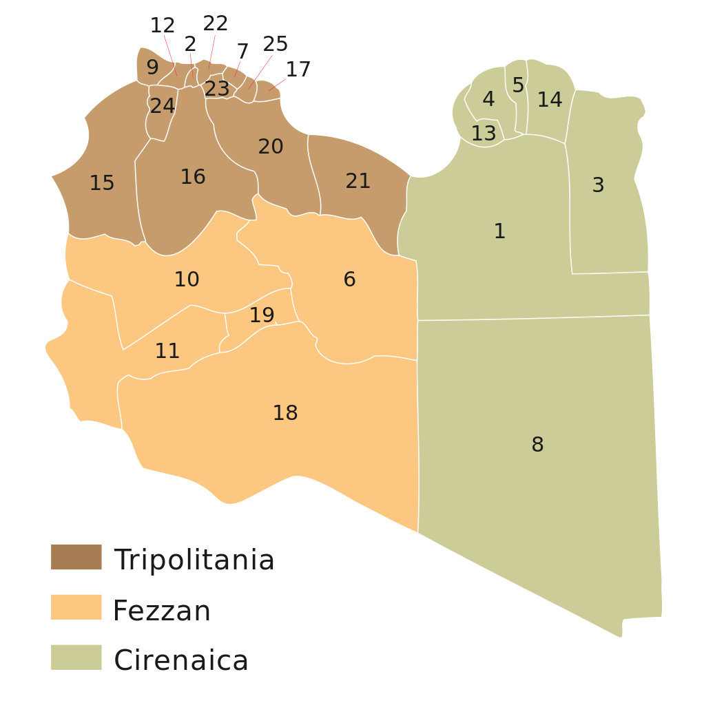
| Description | English: Map of the former (1998 - 2001) twenty-six Shabiyah or Districts of Libya. See also: Subdivisions of Libya. |
| Date | 4.08.2010 |
| Source | http://en.wikipedia.org/wiki/File:LibyaNumbered.png |
| Author | Maxrossomachin |
Licensing
| I, the copyright holder of this work, release this work into the public domain. This applies worldwide. In some countries this may not be legally possible; if so: I grant anyone the right to use this work for any purpose, without any conditions, unless such conditions are required by law. |
File history
Click on a date/time to view the file as it appeared at that time.
| Date/Time | Thumbnail | Dimensions | User | Comment | |
|---|---|---|---|---|---|
| current | 07:36, 15 August 2011 | | 2,020 × 2,023 (41 KB) | Spesh531 | according to page update |
| 19:02, 4 August 2010 |  | 2,020 × 2,023 (31 KB) | Maxrossomachin | {{Information |Description={{en|1=Libya Baladiyat with former governorates.}} |Source=http://en.wikipedia.org/wiki/File:LibyaNumbered.png |Author=Maxrossomachin |Date=4.08.2010 |Permission= |other_versions= }} [[Category:Maps of L |
File usage
The following pages on the English Wikipedia use this file (pages on other projects are not listed):
Global file usage
The following other wikis use this file:
- Usage on ar.wikipedia.org
- Usage on az.wikipedia.org
- Usage on el.wikipedia.org
- Usage on fa.wikipedia.org
- Usage on fr.wikipedia.org
- Usage on it.wikipedia.org
- Usage on ka.wikipedia.org
- Usage on ro.wikipedia.org
- Usage on uk.wikipedia.org
🔥 Top keywords: Main PageSpecial:SearchWikipedia:Featured picturesYasukeHarrison ButkerRobert FicoBridgertonCleopatraDeaths in 2024Joyce VincentXXXTentacionHank AdamsIt Ends with UsYouTubeNew Caledonia2024 Indian general electionHeeramandiDarren DutchyshenSlovakiaKingdom of the Planet of the ApesAttempted assassination of Robert FicoLawrence WongBaby ReindeerXXX: Return of Xander CageThelma HoustonFuriosa: A Mad Max SagaMegalopolis (film)Richard GaddKepler's SupernovaWicked (musical)Sunil ChhetriXXX (2002 film)Ashley MadisonAnya Taylor-JoyPlanet of the ApesNava MauYoung SheldonPortal:Current eventsX-Men '97