
Size of this PNG preview of this SVG file: 539 × 599 pixels. Other resolutions: 216 × 240 pixels | 432 × 480 pixels | 691 × 768 pixels | 921 × 1,024 pixels | 1,842 × 2,048 pixels | 5,677 × 6,312 pixels.
Original file (SVG file, nominally 5,677 × 6,312 pixels, file size: 31 KB)
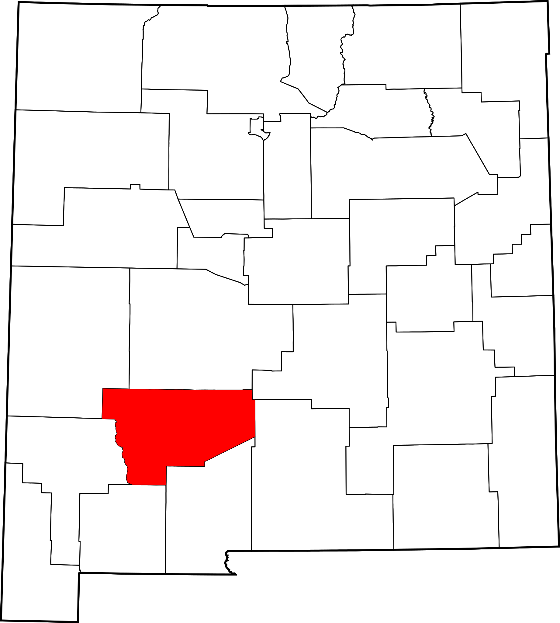
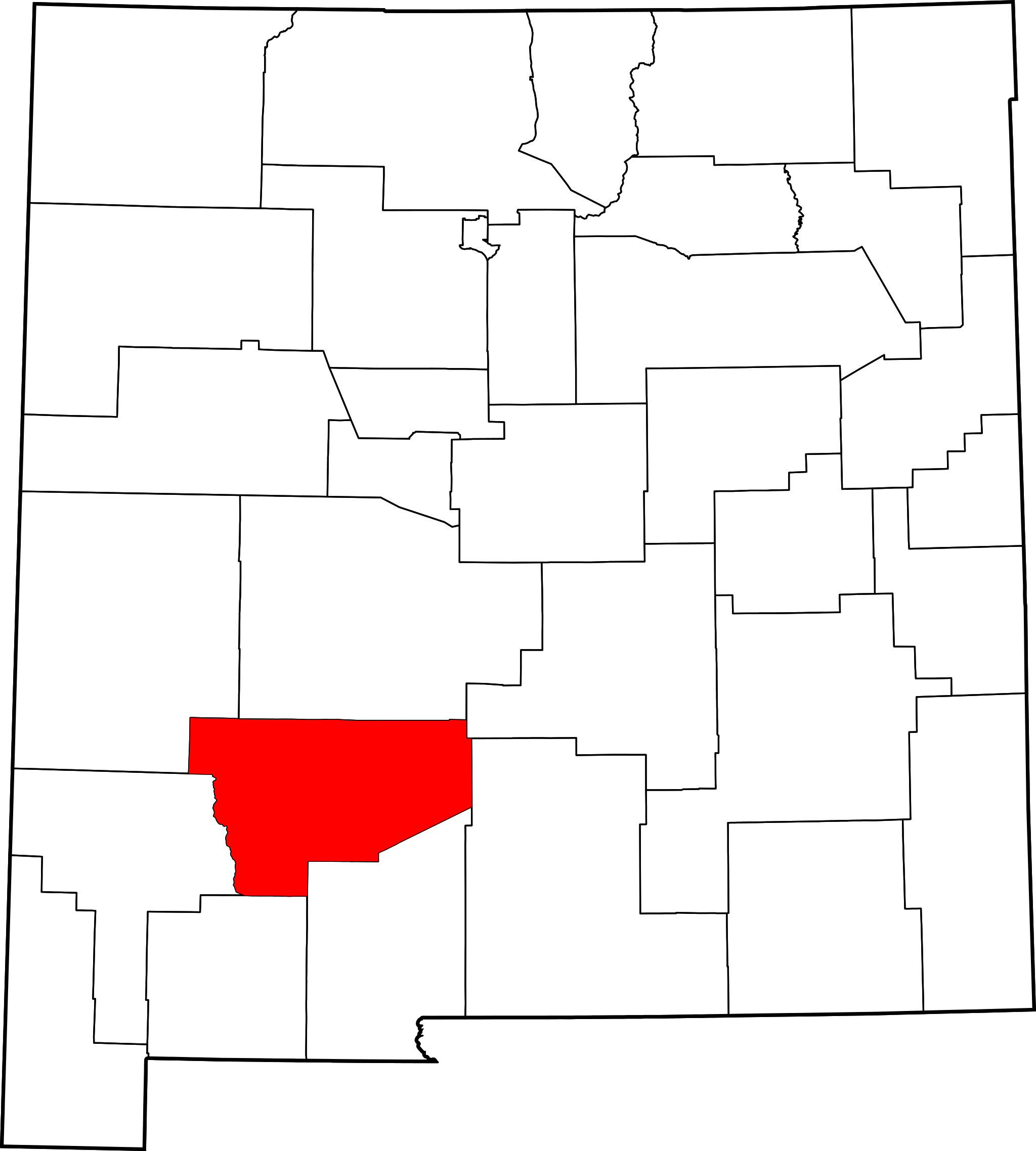
This is a locator map showing Sierra County in New Mexico.
David Benbennick made this map. For more information, see Commons:United States county locator maps. Or see any of the New Mexico county locator maps: Bernalillo · Catron ·Chaves · Cibola ·Colfax · Curry ·De Baca · Doña Ana ·Eddy · Grant ·Guadalupe · Harding ·Hidalgo · Lea ·Lincoln · Los Alamos ·Luna · McKinley ·Mora · Otero ·Quay · Rio Arriba ·Roosevelt · Sandoval ·San Juan · San Miguel ·Santa Fe · Sierra ·Socorro · Taos ·Torrance · Union ·Valencia.
| I, the copyright holder of this work, release this work into the public domain. This applies worldwide. In some countries this may not be legally possible; if so: I grant anyone the right to use this work for any purpose, without any conditions, unless such conditions are required by law. |
File history
Click on a date/time to view the file as it appeared at that time.
| Date/Time | Thumbnail | Dimensions | User | Comment | |
|---|---|---|---|---|---|
| current | 15:31, 12 February 2006 | | 5,677 × 6,312 (31 KB) | David Benbennick | {{subst:User:Dbenbenn/clm|county=Sierra County|state=New Mexico|type=county}} |
File usage
The following pages on the English Wikipedia use this file (pages on other projects are not listed):
- Arrey, New Mexico
- Caballo, New Mexico
- Chloride, New Mexico
- Cuchillo, New Mexico
- Derry, New Mexico
- Elephant Butte, New Mexico
- Elephant Butte, Sierra County, New Mexico
- Engle, New Mexico
- Hermosa, New Mexico
- Hillsboro, New Mexico
- Hot Springs Landing, New Mexico
- Kingston, New Mexico
- Lake Valley, Sierra County, New Mexico
- Las Palomas, New Mexico
- List of counties in New Mexico
- Monticello, New Mexico
- National Register of Historic Places listings in Sierra County, New Mexico
- Oasis, New Mexico
- Placitas, Sierra County, New Mexico
- Sierra County, New Mexico
- Truth or Consequences, New Mexico
- Upham, New Mexico
- Williamsburg, New Mexico
- Winston, New Mexico
- User:AridCeption/sandbox
- User:Nyttend/County templates/NM
- Template:Sierra County, New Mexico
- Category:Populated places in Sierra County, New Mexico
Global file usage
The following other wikis use this file:
- Usage on ar.wikipedia.org
- Usage on bpy.wikipedia.org
- Usage on cdo.wikipedia.org
- Usage on ceb.wikipedia.org
- Usage on ce.wikipedia.org
- Usage on cy.wikipedia.org
- Usage on de.wikipedia.org
- Usage on es.wikipedia.org
- Usage on et.wikipedia.org
- Usage on eu.wikipedia.org
- Usage on fa.wikipedia.org
- Usage on fi.wikipedia.org
- Usage on fr.wikipedia.org
- Usage on ga.wikipedia.org
- Usage on hr.wikipedia.org
- Usage on hu.wikipedia.org
- Usage on hy.wikipedia.org
- Usage on it.wikipedia.org
View more global usage of this file.
🔥 Top keywords: Main PageSpecial:SearchWikipedia:Featured picturesYasukeHarrison ButkerRobert FicoBridgertonCleopatraDeaths in 2024Joyce VincentXXXTentacionHank AdamsIt Ends with UsYouTubeNew Caledonia2024 Indian general electionHeeramandiDarren DutchyshenSlovakiaKingdom of the Planet of the ApesAttempted assassination of Robert FicoLawrence WongBaby ReindeerXXX: Return of Xander CageThelma HoustonFuriosa: A Mad Max SagaMegalopolis (film)Richard GaddKepler's SupernovaWicked (musical)Sunil ChhetriXXX (2002 film)Ashley MadisonAnya Taylor-JoyPlanet of the ApesNava MauYoung SheldonPortal:Current eventsX-Men '97