Size of this preview: 432 × 600 pixels. Other resolutions: 173 × 240 pixels | 346 × 480 pixels | 735 × 1,020 pixels.
Original file (735 × 1,020 pixels, file size: 115 KB, MIME type: image/jpeg)
 | This map image could be re-created using vector graphics as an SVG file. This has several advantages; see Commons:Media for cleanup for more information. If an SVG form of this image is available, please upload it and afterwards replace this template with {{vector version available|new image name}}.It is recommended to name the SVG file “SouthOssetia region detailed map.svg”—then the template Vector version available (or Vva) does not need the new image name parameter. |


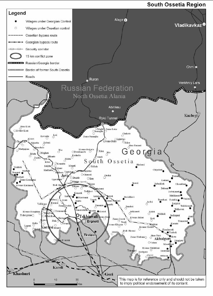
| Description | South Ossetia detailed map |
| Date | november 2004 [1] |
| Source | International Crisis Group: South Ossetia Region (PDF), part of Georgia: Avoiding War in South Ossetia (PDF) |
| Author | International Crisis Group |
| Permission (Reusing this file) | PD ("Unless otherwise specifically stated, no claim to copyright is being asserted by Crisis Group and material on this website may be freely used as in the public domain.") |
| Other versions | en:Image:SouthOssetia region detailed map.JPG |
| This work has been released into the public domain by its author, International Crisis Group. This applies worldwide. In some countries this may not be legally possible; if so: International Crisis Group grants anyone the right to use this work for any purpose, without any conditions, unless such conditions are required by law. |
File history
Click on a date/time to view the file as it appeared at that time.
| Date/Time | Thumbnail | Dimensions | User | Comment | |
|---|---|---|---|---|---|
| current | 11:19, 13 November 2006 | | 735 × 1,020 (115 KB) | Hardscarf | {{Information |Description=South Ossetia detailed map |Source=International Crisis Group: [http://www.internal-displacement.org/8025708F004BE3B1/(httpInfoFiles)/D857161E0D1400E08025709F0041D8AD/$file/South%20Ossetia%20ICG.pdf South Ossetia Region] (PD |
File usage
The following pages on the English Wikipedia use this file (pages on other projects are not listed):
Global file usage
The following other wikis use this file:
- Usage on ar.wikipedia.org
- Usage on azb.wikipedia.org
- Usage on bg.wikipedia.org
- Usage on bs.wikipedia.org
- Usage on ca.wikipedia.org
- Usage on cs.wikipedia.org
- Usage on cs.wikinews.org
- Usage on de.wikipedia.org
- Usage on es.wikipedia.org
- Usage on fa.wikipedia.org
- Usage on fi.wikipedia.org
- Usage on fr.wikipedia.org
- Usage on fr.wikinews.org
- Usage on he.wikipedia.org
- Usage on hr.wikipedia.org
- Usage on it.wikipedia.org
- Usage on ja.wikipedia.org
- Usage on ka.wikipedia.org
- Usage on ko.wikipedia.org
- Usage on mk.wikipedia.org
- Usage on nl.wikipedia.org
- Usage on no.wikipedia.org
- Usage on pt.wikipedia.org
- Usage on ru.wikipedia.org
- Usage on sh.wikipedia.org
- Usage on sq.wikipedia.org
- Usage on sr.wikipedia.org
- Usage on sv.wikipedia.org
- Usage on uk.wikipedia.org
- Usage on ur.wikipedia.org
- Usage on vi.wikipedia.org
View more global usage of this file.
Metadata
🔥 Top keywords: Main PageSpecial:SearchWikipedia:Featured picturesYasukeHarrison ButkerRobert FicoBridgertonCleopatraDeaths in 2024Joyce VincentXXXTentacionHank AdamsIt Ends with UsYouTubeNew Caledonia2024 Indian general electionHeeramandiDarren DutchyshenSlovakiaKingdom of the Planet of the ApesAttempted assassination of Robert FicoLawrence WongBaby ReindeerXXX: Return of Xander CageThelma HoustonFuriosa: A Mad Max SagaMegalopolis (film)Richard GaddKepler's SupernovaWicked (musical)Sunil ChhetriXXX (2002 film)Ashley MadisonAnya Taylor-JoyPlanet of the ApesNava MauYoung SheldonPortal:Current eventsX-Men '97