Highest major summits Of the 20 highest major summits of the Caribbean, only Pico Duarte exceeds 3000 meters (9843 feet) elevation, six peaks exceed 2000 meters (6562 feet), and 15 peaks exceed 1000 meters (3281 feet) elevation.
Of these 20 peaks, three are located in the Dominican Republic, three in Cuba, two in Haiti, two in Saint Kitts and Nevis, one each in Jamaica, Guadeloupe, Dominica, Martinique, Puerto Rico, Saint Vincent and the Grenadines, Saint Lucia, Trinidad and Tobago, Montserrat, and Venezuela.
The 20 highest summits of the Caribbean with at least 500 meters of topographic prominence Rank Mountain peak Country Island Elevation Prominence Isolation Location 1 Pico Duarte [5] [a] Dominican Republic Island of Hispaniola 19°01′23″N 70°59′52″W / 19.0231°N 70.9977°W / 19.0231; -70.9977 (Pico Duarte ) 2 Loma Alto de la Bandera [6] [b] Dominican Republic Island of Hispaniola 18°48′45″N 70°37′36″W / 18.8126°N 70.6268°W / 18.8126; -70.6268 (Loma Alto de la Bandera ) 3 Pic la Selle [7] [c] [d] Haiti Island of Hispaniola 18°21′37″N 71°58′36″W / 18.3602°N 71.9767°W / 18.3602; -71.9767 (Pic la Selle ) 4 Pic Macaya [8] [e] Haiti Island of Hispaniola 18°22′56″N 74°01′27″W / 18.3822°N 74.0243°W / 18.3822; -74.0243 (Pic Macaya ) 5 Loma Gajo en Medio[9] Dominican Republic Island of Hispaniola 18°37′45″N 71°30′39″W / 18.6292°N 71.5108°W / 18.6292; -71.5108 (Loma Gajo en Medio ) 6 Blue Mountain Peak [10] [f] [g] Jamaica Island of Jamaica 18°02′47″N 76°34′44″W / 18.0465°N 76.5788°W / 18.0465; -76.5788 (Blue Mountain Peak ) 7 Pico Turquino [11] [h] [i] Cuba Island of Cuba 19°59′23″N 76°50′10″W / 19.9898°N 76.8360°W / 19.9898; -76.8360 (Pico Turquino ) 8 La Grande Soufrière [12] [j] [k] Guadeloupe île de Basse-Terre 16°02′42″N 61°39′50″W / 16.0449°N 61.6638°W / 16.0449; -61.6638 (La Grande Soufrière ) 9 Morne Diablotins [13] [l] [m] Dominica Island of Dominica 15°30′14″N 61°23′53″W / 15.5040°N 61.3981°W / 15.5040; -61.3981 (Morne Diablotins ) 10 Montagne Pelée [14] [n] [o] Martinique Island of Martinique 14°48′33″N 61°09′55″W / 14.8092°N 61.1654°W / 14.8092; -61.1654 (Montagne Pelée ) 11 Cerro de Punta [15] [16] [17] [p] Puerto Rico Island of Puerto Rico 18°10′20″N 66°35′30″W / 18.1722°N 66.5917°W / 18.1722; -66.5917 (Cerro de Punta ) 12 Gran Piedra[18] [q] Cuba Island of Cuba 20°00′41″N 75°37′37″W / 20.0115°N 75.6270°W / 20.0115; -75.6270 (Gran Piedra ) 13 La Soufrière [19] [r] [s] Saint Vincent and the Grenadines Island of Saint Vincent 13°20′52″N 61°10′34″W / 13.3477°N 61.1761°W / 13.3477; -61.1761 (La Soufrière ) 14 Mount Liamuiga [20] [t] Mount Misery )Saint Kitts and Nevis Saint Christopher Island Island of Saint Kitts )17°22′07″N 62°48′10″W / 17.3685°N 62.8029°W / 17.3685; -62.8029 (Mount Liamuiga ) 15 Pico San Juan [21] [u] Cuba Island of Cuba 21°59′07″N 80°07′58″W / 21.9853°N 80.1327°W / 21.9853; -80.1327 (Pico San Juan ) 16 Nevis Peak [22] [v] Saint Kitts and Nevis Island of Nevis 17°09′00″N 62°35′00″W / 17.1501°N 62.5834°W / 17.1501; -62.5834 (Nevis Peak ) 17 Mount Gimie [23] [w] [x] Saint Lucia Island of Saint Lucia 13°51′49″N 61°00′42″W / 13.8637°N 61.0117°W / 13.8637; -61.0117 (Mount Gimie ) 18 Aripo Peak [24] [y] [z] Trinidad and Tobago Island of Trinidad 10°43′23″N 61°15′00″W / 10.7231°N 61.2499°W / 10.7231; -61.2499 (Aripo Peak ) 19 Soufrière Hills Volcano [25] [aa] Montserrat , United Kingdom Island of Montserrat 16°42′44″N 62°10′32″W / 16.7123°N 62.1756°W / 16.7123; -62.1756 (Soufrière Hills Volcano ) 20 Cerro El Copey [26] [ab] Venezuela Isla de Margarita 10°59′51″N 63°54′45″W / 10.9975°N 63.9126°W / 10.9975; -63.9126 (Cerro El Copey )
Most prominent summits Of the 20 most prominent summits of the Caribbean, only Pico Duarte exceeds 3000 meters (9843 feet) of topographic prominence. Four peaks exceed 2000 meters (6562 feet), seven peaks are ultra-prominent summits with at least 1500 meters (4921 feet) , and 13 peaks exceed 1000 meters (3281 feet) of topographic prominence.
Of these 20 peaks, three are located in the Dominican Republic, two in Haiti, two in Saint Kitts and Nevis, and one each in Jamaica, Cuba, Guadeloupe, Dominica, Martinique, Puerto Rico, Saint Lucia, Trinidad and Tobago, Montserrat, Venezuela, Saba, and Grenada.
The 20 most topographically prominent summits of the Caribbean Rank Mountain peak Country Island Elevation Prominence Isolation Location 1 Pico Duarte [5] [a] Dominican Republic Island of Hispaniola 19°01′23″N 70°59′52″W / 19.0231°N 70.9977°W / 19.0231; -70.9977 (Pico Duarte ) 2 Pic la Selle [7] [c] [d] Haiti Island of Hispaniola 18°21′37″N 71°58′36″W / 18.3602°N 71.9767°W / 18.3602; -71.9767 (Pic la Selle ) 3 Blue Mountain Peak [10] [f] [g] Jamaica Island of Jamaica 18°02′47″N 76°34′44″W / 18.0465°N 76.5788°W / 18.0465; -76.5788 (Blue Mountain Peak ) 4 Pic Macaya [8] [e] Haiti Island of Hispaniola 18°22′56″N 74°01′27″W / 18.3822°N 74.0243°W / 18.3822; -74.0243 (Pic Macaya ) 5 Pico Turquino [11] [h] [i] Cuba Island of Cuba 19°59′23″N 76°50′10″W / 19.9898°N 76.8360°W / 19.9898; -76.8360 (Pico Turquino ) 6 Loma Gajo en Medio[9] Dominican Republic Island of Hispaniola 18°37′45″N 71°30′39″W / 18.6292°N 71.5108°W / 18.6292; -71.5108 (Loma Gajo en Medio ) 7 Loma Alto de la Bandera [6] [b] Dominican Republic Island of Hispaniola 18°48′45″N 70°37′36″W / 18.8126°N 70.6268°W / 18.8126; -70.6268 (Loma Alto de la Bandera ) 8 La Grande Soufrière [12] [j] [k] Guadeloupe île de Basse-Terre 16°02′42″N 61°39′50″W / 16.0449°N 61.6638°W / 16.0449; -61.6638 (La Grande Soufrière ) 9 Morne Diablotins [13] [l] [m] Dominica Island of Dominica 15°30′14″N 61°23′53″W / 15.5040°N 61.3981°W / 15.5040; -61.3981 (Morne Diablotins ) 10 Montagne Pelée [14] [n] [o] Martinique Island of Martinique 14°48′33″N 61°09′55″W / 14.8092°N 61.1654°W / 14.8092; -61.1654 (Montagne Pelée ) 11 Cerro de Punta [15] [16] [17] [p] Puerto Rico Island of Puerto Rico 18°10′20″N 66°35′30″W / 18.1722°N 66.5917°W / 18.1722; -66.5917 (Cerro de Punta ) 12 La Soufrière [19] [r] [s] Saint Vincent and the Grenadines Island of Saint Vincent 13°20′52″N 61°10′34″W / 13.3477°N 61.1761°W / 13.3477; -61.1761 (La Soufrière ) 13 Mount Liamuiga [20] [t] Mount Misery )Saint Kitts and Nevis Saint Christopher Island Island of Saint Kitts )17°22′07″N 62°48′10″W / 17.3685°N 62.8029°W / 17.3685; -62.8029 (Mount Liamuiga ) 14 Nevis Peak [22] [v] Saint Kitts and Nevis Island of Nevis 17°09′00″N 62°35′00″W / 17.1501°N 62.5834°W / 17.1501; -62.5834 (Nevis Peak ) 15 Mount Gimie [23] [w] [x] Saint Lucia Island of Saint Lucia 13°51′49″N 61°00′42″W / 13.8637°N 61.0117°W / 13.8637; -61.0117 (Mount Gimie ) 16 Aripo Peak [24] [y] [z] Trinidad and Tobago Island of Trinidad 10°43′23″N 61°15′00″W / 10.7231°N 61.2499°W / 10.7231; -61.2499 (Aripo Peak ) 17 Soufrière Hills Volcano [25] [aa] Montserrat Island of Montserrat 16°42′44″N 62°10′32″W / 16.7123°N 62.1756°W / 16.7123; -62.1756 (Soufrière Hills Volcano ) 18 Cerro El Copey [26] [ab] Venezuela Isla de Margarita 10°59′51″N 63°54′45″W / 10.9975°N 63.9126°W / 10.9975; -63.9126 (Cerro El Copey ) 19 Mount Scenery [27] [ac] Saba Island of Saba 17°38′05″N 63°14′16″W / 17.6348°N 63.2377°W / 17.6348; -63.2377 (Mount Scenery ) 20 Mount Saint Catherine [28] [ad] [ae] Grenada Island of Grenada 12°09′44″N 61°40′30″W / 12.1623°N 61.6750°W / 12.1623; -61.6750 (Mount Saint Catherine )
Most isolated major summits Of the 20 most isolated major summits of the Caribbean, Pico Duarte and La Grande Soufrière exceed 500 kilometers (310.7 miles) of topographic isolation, seven peaks exceed 200 kilometers (124.3 miles), and 14 peaks exceed 100 kilometers (62.14 miles) of topographic isolation.
Of these 20 peaks, three are located in Cuba, two in the Dominican Republic, two in Haiti, two in Trinidad and Tobago, and one each in Guadeloupe, Puerto Rico, Jamaica, Saint Kitts and Nevis, Saint Vincent and the Grenadines, Granada, the British Virgin Islands, Martinique, Dominica, Montserrat, and Saint Lucia.
The 20 most topographically isolated summits of the Caribbean with at least 500 meters of topographic prominence Rank Mountain peak Country Island Elevation Prominence Isolation Location 1 Pico Duarte [5] [a] Dominican Republic Island of Hispaniola 19°01′23″N 70°59′52″W / 19.0231°N 70.9977°W / 19.0231; -70.9977 (Pico Duarte ) 2 La Grande Soufrière [12] [j] [k] Guadeloupe île de Basse-Terre 16°02′42″N 61°39′50″W / 16.0449°N 61.6638°W / 16.0449; -61.6638 (La Grande Soufrière ) 3 Cerro de Punta [15] [16] [17] [p] Puerto Rico Island of Puerto Rico 18°10′20″N 66°35′30″W / 18.1722°N 66.5917°W / 18.1722; -66.5917 (Cerro de Punta ) 4 Pico San Juan [21] [u] Cuba Island of Cuba 21°59′07″N 80°07′58″W / 21.9853°N 80.1327°W / 21.9853; -80.1327 (Pico San Juan ) 5 Blue Mountain Peak [10] [f] [g] Jamaica Island of Jamaica 18°02′47″N 76°34′44″W / 18.0465°N 76.5788°W / 18.0465; -76.5788 (Blue Mountain Peak ) 6 Pico Turquino [11] [h] [i] Cuba Island of Cuba 19°59′23″N 76°50′10″W / 19.9898°N 76.8360°W / 19.9898; -76.8360 (Pico Turquino ) 7 Pic Macaya [8] [e] Haiti Island of Hispaniola 18°22′56″N 74°01′27″W / 18.3822°N 74.0243°W / 18.3822; -74.0243 (Pic Macaya ) 8 Mount Liamuiga [20] [t] Mount Misery )Saint Kitts and Nevis Saint Christopher Island Island of Saint Kitts )17°22′07″N 62°48′10″W / 17.3685°N 62.8029°W / 17.3685; -62.8029 (Mount Liamuiga ) 9 La Soufrière [19] [r] [s] Saint Vincent and the Grenadines Island of Saint Vincent 13°20′52″N 61°10′34″W / 13.3477°N 61.1761°W / 13.3477; -61.1761 (La Soufrière ) 10 Aripo Peak [24] [y] [z] Trinidad and Tobago Island of Trinidad 10°43′23″N 61°15′00″W / 10.7231°N 61.2499°W / 10.7231; -61.2499 (Aripo Peak ) 11 Mount Saint Catherine [28] [ad] [ae] Grenada Island of Grenada 12°09′44″N 61°40′30″W / 12.1623°N 61.6750°W / 12.1623; -61.6750 (Mount Saint Catherine ) 12 Pic la Selle [7] [c] [d] Haiti Island of Hispaniola 18°21′37″N 71°58′36″W / 18.3602°N 71.9767°W / 18.3602; -71.9767 (Pic la Selle ) 13 Mount Sage [29] [af] British Virgin Islands Island of Tortola 18°24′34″N 64°39′20″W / 18.4095°N 64.6556°W / 18.4095; -64.6556 (Mount Sage ) 14 Gran Piedra[18] [q] Cuba Island of Cuba 20°00′41″N 75°37′37″W / 20.0115°N 75.6270°W / 20.0115; -75.6270 (Gran Piedra ) 15 Montagne Pelée [14] [n] [o] Martinique Island of Martinique 14°48′33″N 61°09′55″W / 14.8092°N 61.1654°W / 14.8092; -61.1654 (Montagne Pelée ) 16 Morne Diablotins [13] [l] [m] Dominica Island of Dominica 15°30′14″N 61°23′53″W / 15.5040°N 61.3981°W / 15.5040; -61.3981 (Morne Diablotins ) 17 Soufrière Hills Volcano [25] [aa] Montserrat Island of Montserrat 16°42′44″N 62°10′32″W / 16.7123°N 62.1756°W / 16.7123; -62.1756 (Soufrière Hills Volcano ) 18 Mount Gimie [23] [w] [x] Saint Lucia Island of Saint Lucia 13°51′49″N 61°00′42″W / 13.8637°N 61.0117°W / 13.8637; -61.0117 (Mount Gimie ) 19 Loma Gajo en Medio[9] Dominican Republic Island of Hispaniola 18°37′45″N 71°30′39″W / 18.6292°N 71.5108°W / 18.6292; -71.5108 (Loma Gajo en Medio ) 20 Main Ridge [30] [ag] [ah] Island of Tobogo 11°17′00″N 60°38′00″W / 11.2833°N 60.6333°W / 11.2833; -60.6333 (Main Ridge )
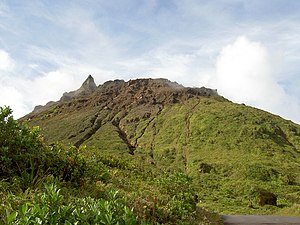
Gallery See also Notes References External links 


.jpg)


