Anexo:Interim Biogeographic Regionalisation for Australia
Interim Biogeographic Regionalisation for Australia (IBRA) es una regionalización biogeográfica de Australia desarrollada por el Departamento de Medio Ambiente, Agua, Patrimonio y las Artes del Gobierno de Australia. Ha sido desarrollada para su uso como una herramienta de planificación, por ejemplo, para el establecimiento de un Sistema de Reservas Nacionales.
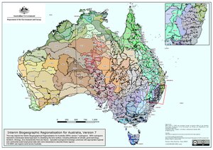
En la escala más amplia, Australia es una parte importante del reino biogeográfico de Australasia, desarrollado por el Fondo Mundial para la Naturaleza. Basado en este sistema, el mundo también se divide en 14 hábitats terrestres, de los cuales ocho son compartidos por Australia. La masa terrestre australiana se divide en 89 biorregiones y 419 subregiones. Cada región es un área terrestre formada por un grupo de ecosistemas que interactúan y que se repiten de forma similar en todo el paisaje.
IBRA se actualiza periódicamente con base en nuevos datos, mejoras en el mapeo y revisión del esquema existente. La versión más reciente es IBRA7, desarrollada durante 2012, que reemplazó a IBRA6.1.
Regiones y subregiones
Esta es una lista de regiones y subregiones bajo IBRA7. Los códigos de región se dan entre paréntesis, seguidos del área, si se conocen. Las imágenes de las regiones son de IBRA6.1, pendiente de creación de mapas para IBRA7.
A
| Regiones y subregiones según IBRA7 | ||||
|---|---|---|---|---|
| Región / subregión | Código IBRA | Área | Estados | Ubicación |
| Arnhem Coast | ARC | 3 335 669 hectáreas (8 242 610,3 acre) | NT |  |
| Murgenella | ARC01 | 113 180 ha (279 673,6 acre) | ||
| Maningrida | ARC02 | 1 741 376 ha (4 303 030 acre) | ||
| Nhulunbuy | ARC03 | 1 159 659 ha (2 865 577,3 acre) | ||
| Groote | ARC04 | 268 735 ha (664 058,1 acre) | ||
| Wessels | ARC05 | 52 720 ha (130 273,8 acre) | ||
| Arnhem Plateau | ARP | 2 306 023 hectáreas (5 698 301,9 acre) | NT |  |
| Alligator | ARP01 | 1 038 621 ha (2 566 486,1 acre) | ||
| Mainoru | ARP02 | 1 267 401 ha (3 131 813,3 acre) | ||
| Alpes Australianos | AUA | 1 232 981 hectáreas (3 046 759,7 acre) | NSW, Vic |  |
| Montañas Snowy | AUA01 | 713 114 ha (1 762 141,5 acre) | ||
| Alpes Victorianos | AUA02 | 519 866 ha (1 284 615,7 acre) | ||
| Avon Wheatbelt | AVW | 9 517 104 hectáreas (23 517 255,4 acre) | WA |  |
| Merredin | AVW01 | 6 524 175 ha (16 121 573,3 acre) | ||
| Katanning | AVW02 | 2 992 929 ha (7 395 682,1 acre) | ||
B
| Regiones y subregiones según IBRA7 | ||||
|---|---|---|---|---|
| Región / subregión | Código IBRA | Área | Estados | Ubicación |
| Ben Lomond | BEL | 657 500 hectáreas (1 624 716,4 acre) | Tas |  |
| Ben Lomond | BEL01 | |||
| Brigalow Belt North | BBN | 33 790 510 hectáreas (83 498 094,8 acre) | Qld |  |
| Townsville Plains | BBN01 | 763 495 ha (1 886 635,6 acre) | ||
| Bogie River Hills | BBN02 | 1 054 392 ha (2 605 457,1 acre) | ||
| Cape River Hills | BBN03 | 747 393 ha (1 846 846,7 acre) | ||
| Beucazon Hills | BBN04 | 95 821 ha (236 778,6 acre) | ||
| Wyarra Hills | BBN05 | 397 935 ha (983 317,9 acre) | ||
| Northern Bowen Basin | BBN06 | 1 316 957 ha (3 254 268,7 acre) | ||
| Belyando Downs | BBN07 | 1 772 127 ha (4 379 017,3 acre) | ||
| Upper Belyando Floodout | BBN08 | 466 275 ha (1 152 189,6 acre) | ||
| Anakie Inlier | BBN09 | 382 284 ha (944 643,5 acre) | ||
| Basalt Downs | BBN10 | 1 274 731 ha (3 149 926,1 acre) | ||
| Isaac-Comet Downs | BBN11 | 2 693 397 ha (6 655 523 acre) | ||
| Montañas de Nebo-Connors | BBN12 | 449 269 ha (1 110 166,9 acre) | ||
| South Drummond Basin | BBN13 | 1 009 244 ha (2 493 894 acre) | ||
| Marlborough Plains | BBN14 | 1 250 611 ha (3 090 324,4 acre) | ||
| Brigalow Belt South | BBS | 27 219 776 hectáreas (67 261 471,9 acre) | Qld / NSW |  |
| Claude River Downs | BBS01 | 1 026 214 ha (2 535 827,8 acre) | ||
| Woorabinda | BBS02 | 749 785 ha (1 852 757,4 acre) | ||
| Cordillera Boomer | BBS03 | 220 541 ha (544 968,2 acre) | ||
| Mount Morgan Ranges | BBS04 | 1 275 970 ha (3 152 987,7 acre) | ||
| Callide Creek Downs | BBS05 | 30 133 ha (74 460,2 acre) | ||
| Arcadia | BBS06 | 715 288 ha (1 767 513,6 acre) | ||
| Dawson River Downs | BBS07 | 982 807 ha (2 428 566,8 acre) | ||
| Banana-Auburn Ranges | BBS08 | 1 547 555 ha (3 824 088,3 acre) | ||
| Buckland Basalts | BBS09 | 281 306 ha (695 121,6 acre) | ||
| Carnarvon Ranges | BBS10 | 2 263 686 ha (5 593 685 acre) | ||
| Taroom Downs | BBS11 | 652 005 ha (1 611 138 acre) | ||
| Southern Downs | BBS12 | 4 264 666 ha (10 538 209,9 acre) | ||
| Barakula | BBS13 | 1 301 712 ha (3 216 597,6 acre) | ||
| Dulacca Downs | BBS14 | 162 442 ha (401 402,6 acre) | ||
| Weribone High | BBS15 | 966 510 ha (2 388 296,1 acre) | ||
| Tara Downs | BBS16 | 511 339 ha (1 263 545,1 acre) | ||
| Eastern Darling Downs | BBS17 | 1 697 945 ha (4 195 709,8 acre) | ||
| Inglewood Sandstones | BBS18 | 1 219 008 ha (3 012 231,7 acre) | ||
| Moonie-Commoron Floodout | BBS19 | 750 661 ha (1 854 922,1 acre) | ||
| Moonie-Barwon Interfluve | BBS20 | 765 231 ha (1 890 925,3 acre) | ||
| Northern Basalts | BBS21 | 624 671 ha (1 543 594,3 acre) | ||
| Northern Outwash | BBS22 | 700 241 ha (1 730 331,7 acre) | ||
| Pilliga Outwash | BBS23 | 535 392 ha (1 322 981,3 acre) | ||
| Pilliga | BBS24 | 1 732 137 ha (4 280 200 acre) | ||
| Liverpool Plains | BBS25 | 941 752 ha (2 327 117,8 acre) | ||
| Cordillera Liverpool | BBS26 | 521 960 ha (1 289 790,1 acre) | ||
| Talbragar Valley | BBS27 | 203 894 ha (503 832,6 acre) | ||
| Narrandool | BBS28 | 303 754 ha (750 591,8 acre) | ||
| Broken Hill Complex | BHC | 5 635 422 hectáreas (13 925 418,7 acre) | SA / NSW |  |
| Barrier Range | BHC01 | 1 802 996 ha (4 455 296,2 acre) | ||
| Mootwingee Downs | BHC02 | 630 694 ha (1 558 477,4 acre) | ||
| Scopes Range | BHC03 | 260 806 ha (644 465,1 acre) | ||
| Barrier Range Outwash | BHC04 | 1 954 973 ha (4 830 839,2 acre) | ||
| Bimbowrie | BHC05 | 279 258 ha (690 060,9 acre) | ||
| Curnamona | BHC06 | 706 696 ha (1 746 282,3 acre) | ||
| Burt Plain | BRT | 7 379 719 hectáreas (18 235 666,7 acre) | NT |  |
| Yuendumu | BRT01 | 2 931 061 ha (7 242 803,1 acre) | ||
| Atartinga | BRT02 | 3 531 111 ha (8 725 557,6 acre) | ||
| Mount Chapple | BRT03 | 390 981 ha (966 134,2 acre) | ||
| Dulcie | BRT04 | 526 567 ha (1 301 174,2 acre) | ||
C
| Regiones y subregiones según IBRA7 | ||||
|---|---|---|---|---|
| Región / subregión | Código IBRA | Área | Estados | Ubicación |
| Cape York Peninsula | CYP | 12 256 457 hectáreas (30 286 338 acre) | Qld |  |
| Coen - Yambo Inlier | CYP01 | 2 312 126 hectáreas (5 713 382,7 acre) | ||
| Starke Coastal Lowlands | CYP02 | 512 498 hectáreas (1 266 409 acre) | ||
| Cabo York - Estrecho de Torres | CYP03 | 94 367 hectáreas (233 185,7 acre) | ||
| Areniscas de Jardine-Pascoe | CYP04 | 1 444 223 hectáreas (3 568 749,6 acre) | ||
| Areniscas de Battle Camp | CYP05 | 504 409 hectáreas (1 246 420,7 acre) | ||
| Laura Lowlands | CYP06 | 1 791 228 hectáreas (4 426 216,9 acre) | ||
| Weipa Plateau | CYP07 | 2 848 753 hectáreas (7 039 415,7 acre) | ||
| (Northern) Holroyd Plain | CYP08 | 2 464 074 hectáreas (6 088 854,1 acre) | ||
| Coastal Plains | CYP09 | 284 780 hectáreas (703 706,1 acre) | ||
| Carnarvon | CAR | 8 430 172 hectáreas (20 831 390,3 acre) | WA |  |
| Cabo Cordillera | CAR01 | 2 380 498 hectáreas (5 882 333,5 acre) | ||
| Wooramel | CAR02 | 6 049 674 hectáreas (14 949 056,8 acre) | ||
| Central Arnhem | CEA | 3 462 433 hectáreas (8 555 850,7 acre) | NT |  |
| Wilton | CEA01 | 3 137 973 hectáreas (7 754 093,3 acre) | ||
| Parson | CEA02 | 324 460 hectáreas (801 757,4 acre) | ||
| Central Kimberley | CEK | 7 675 587 hectáreas (18 966 771,8 acre) | WA |  |
| Pentecost | CEK01 | 4 397 260 hectáreas (10 865 856,5 acre) | ||
| Hart | CEK02 | 2 324 667 hectáreas (5 744 372,2 acre) | ||
| Monte Eliza | CEK03 | 953 661 hectáreas (2 356 545,6 acre) | ||
| Central Mackay Coast | CMC | 1 464 208 hectáreas (3 618 133,6 acre) | Qld |  |
| Whitsunday | CMC01 | 89 179 hectáreas (220 365,9 acre) | ||
| Proserpine - Sarina Lowlands | CMC02 | 466 498 hectáreas (1 152 740,6 acre) | ||
| Clarke - Connors Ranges | CMC03 | 631 985 hectáreas (1 561 667,6 acre) | ||
| Byfield | CMC04 | 127 697 hectáreas (315 545,9 acre) | ||
| Manifold | CMC05 | 67 885 hectáreas (167 747,3 acre) | ||
| Debella | CMC06 | 80 964 hectáreas (200 066,2 acre) | ||
| Central Ranges | CER | 10 164 044 hectáreas (25 115 877,5 acre) | WA, NT, SA |  |
| Mann-Musgrave Block | CER01 | 9 214 685 hectáreas (22 769 962,4 acre) | ||
| Wataru | CER02 | 423 360 hectáreas (1 046 144,4 acre) | ||
| Everard Block | CER03 | 525 998 hectáreas (1 299 768,2 acre) | ||
| Channel Country | CHC | 30 409 437 hectáreas (75 143 288,9 acre) | NT, Qld, NSW, SA |  |
| Toko Plains | CHC01 | 2 825 712 hectáreas (6 982 480,2 acre) | ||
| Desierto Pedregoso de Sturt | CHC02 | 8 945 360 hectáreas (22 104 446,4 acre) | ||
| Goneaway Tablelands | CHC03 | 5 182 219 hectáreas (12 805 530,7 acre) | ||
| Diamantina-Eyre | CHC04 | 1 456 544 hectáreas (3 599 195,4 acre) | ||
| Cooper-Diamantina Plains | CHC05 | 4 136 121 hectáreas (10 220 568,5 acre) | ||
| Coongie | CHC06 | 1 736 594 hectáreas (4 291 213,4 acre) | ||
| Lake Pure | CHC07 | 1 204 027 hectáreas (2 975 212,9 acre) | ||
| Noccundra Slopes | CHC08 | 1 798 759 hectáreas (4 444 826,4 acre) | ||
| Tibooburra Downs | CHC09 | |||
| Core Ranges | CHC10 | 139 224 hectáreas (344 029,7 acre) | ||
| Bulloo | CHC11 | 1 077 480 hectáreas (2 662 508,7 acre) | ||
| Bulloo Dunefields | CHC12 | 1 326 712 hectáreas (3 278 373,9 acre) | ||
| Depresión Central | CHC13 | 580 685 hectáreas (1 434 902,6 acre) | ||
| Cobar Peneplain | COP | 7 385 346 hectáreas (18 249 571,3 acre) | NSW |  |
| Boorindal Plains | COP1 | 400 236 hectáreas (989 003,8 acre) | ||
| Barnato Downs | COP2 | 1 773 542 hectáreas (4 382 513,9 acre) | ||
| Canbelego Downs | COP3 | 2 001 425 hectáreas (4 945 624,5 acre) | ||
| Nymagee | COP4 | 2 070 061 hectáreas (5 115 227,6 acre) | ||
| Lachlan Plains | COP5 | 1 140 082 hectáreas (2 817 201,5 acre) | ||
| Coolgardie | COO | 12 912 209 hectáreas (31 906 735,1 acre) | WA |  |
| Mardabilla | COO1 | 1 843 125 hectáreas (4 554 457 acre) | ||
| Southern Cross | COO2 | 6 010 838 hectáreas (14 853 091 acre) | ||
| Eastern Goldfields | COO3 | 5 058 246 hectáreas (12 499 187 acre) | ||
| Coral Sea | COS | 17 167 hectáreas (42 420,5 acre) | ||
D
| Regiones y subregiones según IBRA7 | ||||
|---|---|---|---|---|
| Región / subregión | Código IBRA | Área | Estados | Ubicación |
| Daly Basin | DAB | 2 092 229 hectáreas (5 170 005,9 acre) | NT |  |
| Daly Basin | DAB01 | |||
| Dampierland | DAL | 8 360 871 hectáreas (20 660 143,9 acre) | WA |  |
| Fitzroy Trough | DAL01 | 3 432 084 hectáreas (8 480 856,8 acre) | ||
| Pindanland | DAL02 | 4 928 787 hectáreas (12 179 287,2 acre) | ||
| Darling Riverine Plains | DRP | 10 699 769 hectáreas (26 439 681,6 acre) | Qld / NSW |  |
| Culgoa-Bokhara | DRP01 | 1 354 799 hectáreas (3 347 778,3 acre) | ||
| Warrambool-Moonie | DRP02 | 1 151 637 hectáreas (2 845 754,5 acre) | ||
| Castlereagh-Barwon | DRP03 | 4 500 355 hectáreas (11 120 609,6 acre) | ||
| Bogan-Macquarie | DRP04 | 1 999 951 hectáreas (4 941 982,2 acre) | ||
| Louth Plains | DRP05 | 276 573 hectáreas (683 426,2 acre) | ||
| Wilcannia Plains | DRP06 | 504 562 hectáreas (1 246 798,8 acre) | ||
| Menindee | DRP07 | 653 935 hectáreas (1 615 907,1 acre) | ||
| Great Darling Anabranch | DRP08 | 147 138 hectáreas (363 585,6 acre) | ||
| Pooncarie-Darling | DRP09 | 110 819 hectáreas (273 839,5 acre) | ||
| Darwin Coastal | DAC | 2 843 199 hectáreas (7 025 691,5 acre) | NT |  |
| Darwin Coastal | DAC01 | |||
| Davenport Murchison Ranges | DMR | 5 805 108 hectáreas (14 344 721,6 acre) | NT |  |
| Ashburton Range | DMR01 | 1 218 621 hectáreas (3 011 275,4 acre) | ||
| Davenport | DMR02 | 1 589 590 hectáreas (3 927 959 acre) | ||
| Barkly | DMR03 | 2 996 897 hectáreas (7 405 487,2 acre) | ||
| Desert Uplands | DEU | 6 941 095 hectáreas (17 151 804,1 acre) | Qld |  |
| Prairie-Torrens Creeks Alluvials | DEU01 | 1 580 384 hectáreas (3 905 210,5 acre) | ||
| Alice Tableland | DEU02 | 2 866 760 hectáreas (7 083 912 acre) | ||
| Cape-Campaspe Plains | DEU03 | 1 007 026 hectáreas (2 488 413,2 acre) | ||
| Jericho | DEU04 | 1 486 926 hectáreas (3 674 270,9 acre) | ||
E
| Regiones y subregiones según IBRA7 | ||||
|---|---|---|---|---|
| Región / subregión | Código IBRA | Área | Estados | Ubicación |
| Einasleigh Uplands | EIU | 11 625 726 hectáreas (28 727 769,2 acre) | Qld |  |
| Georgetown - Croydon | EIU01 | 1 041 407 hectáreas (2 573 370,5 acre) | ||
| Kidston | EIU02 | 2 929 528 hectáreas (7 239 014,9 acre) | ||
| Hodgkinson Basin | EIU03 | 1 607 221 hectáreas (3 971 526,1 acre) | ||
| Río Broken | EIU04 | 3 309 590 hectáreas (8 178 167,8 acre) | ||
| Undara - Toomba Basalts | EIU05 | 2 076 208 hectáreas (5 130 417,2 acre) | ||
| Herberton - Wairuna | EIU06 | 661 771 hectáreas (1 635 270,3 acre) | ||
| Esperance Plains | ESP | 2 921 327 hectáreas (7 218 749,8 acre) | WA |  |
| Fitzgerald | ESP01 | 1 577 938 hectáreas (3 899 166,3 acre) | ||
| Recherche | ESP02 | 1 343 390 hectáreas (3 319 586 acre) | ||
| Eyre Yorke Block | EYB | 6 120 409 hectáreas (15 123 846,6 acre) | SA |  |
| Southern Yorke | EYB01 | 438 470 hectáreas (1 083 482 acre) | ||
| St Vincent | EYB02 | 1 093 789 hectáreas (2 702 809,1 acre) | ||
| Eyre Hills | EYB03 | 1 172 576 hectáreas (2 897 495,8 acre) | ||
| Talia | EYB04 | 1 096 175 hectáreas (2 708 705 acre) | ||
| Eyre Mallee | EYB05 | 2 319 398 hectáreas (5 731 352,2 acre) | ||
F
| Regiones y subregiones según IBRA7 | ||||
|---|---|---|---|---|
| Región / subregión | Código IBRA | Área | Estados | Ubicación |
| Finke | FIN | 7 267 416 hectáreas (17 958 160,2 acre) | NT / SA |  |
| Henbury | FIN01 | 2 257 063 hectáreas (5 577 319,2 acre) | ||
| Finke River | FIN02 | 1 601 516 hectáreas (3 957 428,7 acre) | ||
| Tieyon | FIN03 | 2 505 610 hectáreas (6 191 491,7 acre) | ||
| Pedirka | FIN04 | 903 228 hectáreas (2 231 923 acre) | ||
| Flinders Lofty Block | FLB | 6 615 765 hectáreas (16 347 896,9 acre) | SA / NSW |  |
| Mount Lofty Ranges | FLB01 | 300 580 hectáreas (742 748,7 acre) | ||
| Broughton | FLB02 | 1 032 918 hectáreas (2 552 393,7 acre) | ||
| Olary Spur | FLB02 | 1 745 479 hectáreas (4 313 168,7 acre) | ||
| Southern Flinders | FLB04 | 728 317 hectáreas (1 799 708,9 acre) | ||
| Northern Flinders | FLB05 | 1 846 804 hectáreas (4 563 548 acre) | ||
| Central Flinders | FLB06 | 961 667 hectáreas (2 376 328,8 acre) | ||
| Furneaux | FUR | 537 543 hectáreas (1 328 296,5 acre) | Tas / Vic | |
| Promontorio de Wilsons | FUR01 | 41 144 hectáreas (101 668,9 acre) | ||
| Flinders | FUR02 | 496 398 hectáreas (1 226 625,1 acre) | ||
G
| Regiones y subregiones según IBRA7 | ||||
|---|---|---|---|---|
| Región / subregión | Código IBRA | Área | Estados | Ubicación |
| Gascoyne | GAS | 18 075 257 hectáreas (44 664 893,3 acre) | WA |  |
| Ashburton | GAS01 | 3 687 030 hectáreas (9 110 841,5 acre) | ||
| Carnegie | GAS02 | 4 718 656 hectáreas (11 660 042,6 acre) | ||
| Augustus | GAS03 | 9 669 571 hectáreas (23 894 009,2 acre) | ||
| Gawler | GAW | 12 002 883 hectáreas (29 659 743,6 acre) | SA |  |
| Myall Plains | GAW01 | 1 088 767 hectáreas (2 690 399,5 acre) | ||
| Gawler Volcanics | GAW02 | 1 556 182 hectáreas (3 845 406,1 acre) | ||
| Gawler Lakes | GAW03 | 2 049 193 hectáreas (5 063 661,7 acre) | ||
| Arcoona Plateau | GAW04 | 1 089 865 hectáreas (2 693 112,7 acre) | ||
| Kingoonya | GAW05 | 1 922 414 hectáreas (4 750 384,2 acre) | ||
| Torrens | GAW06 | 1 439 093 hectáreas (3 556 073,1 acre) | ||
| Roxby | GAW07 | 1 409 305 hectáreas (3 482 465,4 acre) | ||
| Commonwealth Hill | GAW08 | 1 448 062 hectáreas (3 578 236 acre) | ||
| Geraldton Sandplains | GES | 3 142 149 hectáreas (7 764 412,4 acre) | WA |  |
| Geraldton Hills | GES01 | 1 969 997 hectáreas (4 867 964,3 acre) | ||
| Leseur Sandplain | GES02 | 1 172 152 hectáreas (2 896 448,1 acre) | ||
| Gibson Desert | GID | 15 628 918 hectáreas (38 619 863,3 acre) | WA |  |
| Lateritic Plain | GID01 | 12 714 805 hectáreas (31 418 939,6 acre) | ||
| Dune Field | GID02 | 2 914 114 hectáreas (7 200 926,2 acre) | ||
| Gran Desierto Arenoso | GSD | 39 486 135 hectáreas (97 572 278,3 acre) | NT / WA |  |
| McLarty | GSD01 | 12 316 754 hectáreas (30 435 335 acre) | ||
| Mackay | GSD02 | 25 698 395 hectáreas (63 502 060,9 acre) | ||
| Ehrenberg | GSD03 | 375 668 hectáreas (928 295 acre) | ||
| Amedeus | GSD04 | 722 845 hectáreas (1 786 187,3 acre) | ||
| Lake Bennett | GSD05 | 289 541 hectáreas (715 470,8 acre) | ||
| Lake Lewis | GSD06 | 82 932 hectáreas (204 929,3 acre) | ||
| Gran Desierto de Victoria | GVD | 42 246 564 hectáreas (104 393 440,8 acre) | SA / WA |  |
| Shield | GVD01 | 4 741 854 hectáreas (11 717 366,1 acre) | ||
| Central | GVD02 | 12 590 867 hectáreas (31 112 682,4 acre) | ||
| Maralinga | GVD03 | 11 460 762 hectáreas (28 320 134,6 acre) | ||
| Kintore | GVD04 | 4 961 542 hectáreas (12 260 226,4 acre) | ||
| Tallaringa | GVD05 | 3 663 149 hectáreas (9 051 830,3 acre) | ||
| Yellabinna | GVD06 | 4 828 389 hectáreas (11 931 198,5 acre) | ||
| Gulf Coastal | GUC | 2 711 718 hectáreas (6 700 795,2 acre) | NT |  |
| Limmen | GUC01 | 12 714 805 hectáreas (31 418 939,6 acre) | ||
| Pellews | GUC02 | 2 914 114 hectáreas (7 200 926,2 acre) | ||
| Gulf Fall and Uplands | GFU | 11 847 909 hectáreas (29 276 794,8 acre) | NT / Qld |  |
| McArthur | GFU01 | 9 330 938 hectáreas (23 057 229,6 acre) | ||
| Nicholson | GFU02 | 2 516 971 hectáreas (6 219 565,3 acre) | ||
| Gulf Plains | GUP | 22 041 825 hectáreas (54 466 487,6 acre) | NT / Qld |  |
| Karumba Plains | GUP01 | 1 057 366 hectáreas (2 612 806 acre) | ||
| Armraynald Plains | GUP02 | 1 589 437 hectáreas (3 927 580,9 acre) | ||
| Woondoola Plains | GUP03 | 2 375 110 hectáreas (5 869 019,4 acre) | ||
| Mitchell-Gilbert Fans | GUP04 | 5 262 816 hectáreas (13 004 690,1 acre) | ||
| Claraville Plains | GUP05 | 3 738 013 hectáreas (9 236 823,1 acre) | ||
| Holroyd Plain-Red Plateau | GUP06 | 2 208 468 hectáreas (5 457 238,5 acre) | ||
| Doomadgee Plains | GUP07 | 1 831 823 hectáreas (4 526 529,2 acre) | ||
| Donors Plateau | GUP08 | 2 449 964 hectáreas (6 053 987,5 acre) | ||
| Gilberton Plateau | GUP09 | 1 403 937 hectáreas (3 469 200,8 acre) | ||
| Wellesley Islands | GUP10 | 124 893 hectáreas (308 617,1 acre) | ||
H
| Regiones y subregiones según IBRA7 | ||||
|---|---|---|---|---|
| Región / subregión | Código IBRA | Área | Estados | Ubicación |
| Hampton | HAM | 1 088 198 hectáreas (2 688 993,4 acre) | WA |  |
| Hampton | HAM01 | |||
I
| Regiones y subregiones según IBRA7 | ||||
|---|---|---|---|---|
| Región / subregión | Código IBRA | Área | Estados | Ubicación |
| Indian Tropical Islands | ITI | 27 329 hectáreas (67 531,4 acre) | ||
| Isla de Navidad | ITI01 | 13 664 hectáreas (33 764,4 acre) | ||
| Islas Cocos | ITI02 | 1463 hectáreas (3615,1 acre) | ||
| Islas de coral del mar de Timor | ITI03 | 12 203 hectáreas (30 154,2 acre) | ||
J
| Regiones y subregiones según IBRA7 | ||||
|---|---|---|---|---|
| Región / subregión | Código IBRA | Área | Estados | Ubicación |
| Jarrah Forest | JAF | 4 509 074 hectáreas (11 142 154,7 acre) | WA |  |
| Northern Jarrah Forest | JAF01 | 1 898 799 hectáreas (4 692 030,4 acre) | ||
| Southern Jarrah Forest | JAF02 | 2 610 275 hectáreas (6 450 124,3 acre) | ||
K
| Regiones y subregiones según IBRA7 | ||||
|---|---|---|---|---|
| Región / subregión | Código IBRA | Área | Estados | Ubicación |
| Kanmantoo | KAN | 812 415 hectáreas (2 007 519,4 acre) | SA |  |
| Isla Canguro | KAN01 | 441 685 hectáreas (1 091 426,4 acre) | ||
| Fleurieu | KAN02 | 370 730 hectáreas (916 093 acre) | ||
| King | KIN | 425 567 hectáreas (1 051 598 acre) | Tas |  |
| King | KIN01 | |||
L
| Regiones y subregiones según IBRA7 | ||||
|---|---|---|---|---|
| Región / subregión | Código IBRA | Área | Estados | Ubicación |
| Little Sandy Desert | LSD | 11 089 857 hectáreas (27 403 609,2 acre) | WA |  |
| Rudall | LSD01 | 991 277 hectáreas (2 449 496,6 acre) | ||
| Trainor | LSD02 | 10 098 580 hectáreas (24 954 112,6 acre) | ||
M
| Regiones y subregiones según IBRA7 | ||||
|---|---|---|---|---|
| Región / subregión | Código IBRA | Área | Estados | Ubicación |
| MacDonnell Ranges | MAC | 3 929 444 hectáreas (9 709 859 acre) | NT |  |
| McDonnell | MAC01 | 1 483 959 hectáreas (3 666 939,3 acre) | ||
| Watarrka | MAC02 | 1 092 782 hectáreas (2 700 320,7 acre) | ||
| Hartz Range | MAC03 | 1 352 702 hectáreas (3 342 596,5 acre) | ||
| Mallee | MAL | 7 397 559 hectáreas (18 279 750,2 acre) | WA |  |
| Eastern Mallee | MAL01 | 3 415 839 hectáreas (8 440 714,5 acre) | ||
| Western Mallee | MAL02 | 3 981 720 hectáreas (9 839 035,7 acre) | ||
| Mitchell Grass Downs | MGD | 33 468 761 hectáreas (82 703 036,4 acre) | NT / Qld |  |
| Sylvester | MGD01 | 1 153 283 hectáreas (2 849 821,8 acre) | ||
| Barkly Tableland | MGD02 | 9 479 612 hectáreas (23 424 610,7 acre) | ||
| Georgina Limestone | MGD03 | 2 292 026 hectáreas (5 663 714,6 acre) | ||
| Southwestern Downs | MGD04 | 3 715 454 hectáreas (9 181 078,7 acre) | ||
| Kynuna Plateau | MGD05 | 2 293 311 hectáreas (5 666 889,9 acre) | ||
| Northern Downs | MGD06 | 435 263 hectáreas (1 075 557,3 acre) | ||
| Central Downs | MGD07 | 9 378 817 hectáreas (23 175 541 acre) | ||
| Southern Wooded Downs | MGD08 | 4 720 995 hectáreas (11 665 822,4 acre) | ||
| Mount Isa Inlier | MII | 6 778 263 hectáreas (16 749 437,8 acre) | Qld |  |
| Southwestern Plateaus and Floodouts | MII01 | 1 333 519 hectáreas (3 295 194,3 acre) | ||
| Thorntonia | MII02 | 802 892 hectáreas (1 983 987,6 acre) | ||
| Mount Isa | MII03 | 4 641 851 hectáreas (11 470 253,5 acre) | ||
| Mulga Lands | MUL | 25 188 333 hectáreas (62 241 671,3 acre) | NSW / Qld |  |
| West Balonne Plains | MUL01 | 1 991 194 hectáreas (4 920 343,2 acre) | ||
| Eastern Mulga Plains | MUL02 | 1 563 269 hectáreas (3 862 918,4 acre) | ||
| Nebine Plains, Block Range | MUL03 | 1 898 731 hectáreas (4 691 862,3 acre) | ||
| North Eastern Plains | MUL04 | 660 369 hectáreas (1 631 805,9 acre) | ||
| Warrego Plains | MUL05 | 2 492 085 hectáreas (6 158 070,7 acre) | ||
| Langlo Plains | MUL06 | 1 290 484 hectáreas (3 188 852,6 acre) | ||
| Cuttaburra-Paroo | MUL07 | 1 703 985 hectáreas (4 210 634,9 acre) | ||
| West Warrego | MUL08 | 4 790 087 hectáreas (11 836 552,3 acre) | ||
| Northern Uplands | MUL09 | 1 147 549 hectáreas (2 835 652,8 acre) | ||
| West Bulloo | MUL10 | 2 852 104 hectáreas (7 047 696,2 acre) | ||
| Urisino Sandplains | MUL11 | 2 007 350 hectáreas (4 960 265,5 acre) | ||
| Warrego Sands | MUL12 | 479 471 hectáreas (1 184 797,6 acre) | ||
| Kerribree Basin | MUL13 | 399 576 hectáreas (987 372,9 acre) | ||
| White Cliffs Plateau | MUL14 | 1 074 309 hectáreas (2 654 673 acre) | ||
| Paroo Overflow | MUL15 | 301 217 hectáreas (744 322,8 acre) | ||
| Paroo-Darling Sands | MUL16 | 536 556 hectáreas (1 325 857,6 acre) | ||
| Murchison | MUR | 28 120 554 hectáreas (69 487 340,8 acre) | WA |  |
| Eastern Murchison | MUR01 | 21 135 040 hectáreas (52 225 775 acre) | ||
| Western Murchison | MUR02 | 6 985 514 hectáreas (17 261 565,8 acre) | ||
| Murray Darling Depression | MDD | 19 958 349 hectáreas (49 318 110,8 acre) | NSW, SA, Vic |  |
| South Olary Plain | MDD01 | 5 439 224 hectáreas (13 440 603,3 acre) | ||
| Murray Mallee | MDD02 | 5 037 583 hectáreas (12 448 127,7 acre) | ||
| Murray Lakes and Coorong | MDD03 | 249 191 hectáreas (615 763,8 acre) | ||
| Lowan Mallee | MDD04 | 2 391 719 hectáreas (5 910 061,1 acre) | ||
| Wimmera | MDD05 | 2 145 380 hectáreas (5 301 344,7 acre) | ||
| Depresión de Darling | MDD06 | 3 662 438 hectáreas (9 050 073,4 acre) | ||
| Braemer | MDD07 | 1 032 815 hectáreas (2 552 139,2 acre) | ||
N
| Regiones y subregiones según IBRA7 | ||||
|---|---|---|---|---|
| Región / subregión | Código IBRA | Área | Estados | Ubicación |
| Nandewar | NAN | 2 701 977 hectáreas (6 676 724,7 acre) | NSW / Qld |  |
| Nandewar Northern Complex | NAN01 | 962 254 hectáreas (2 377 779,3 acre) | ||
| Inverell Basalts | NAN02 | 230 854 hectáreas (570 452,2 acre) | ||
| Kaputar | NAN03 | 78 307 hectáreas (193 500,6 acre) | ||
| Peel | NAN04 | 1 430 562 hectáreas (3 534 992,6 acre) | ||
| Naracoorte Coastal Plain | NCP | 2 458 215 hectáreas (6 074 376,2 acre) | SA / Vic |  |
| Bridgewater | NCP01 | 463 723 hectáreas (1 145 883,5 acre) | ||
| Glenelg Plain | NCP02 | 554 775 hectáreas (1 370 877,7 acre) | ||
| Lucindale | NCP03 | 731 656 hectáreas (1 807 959,8 acre) | ||
| Tintinara | NCP04 | 708 061 hectáreas (1 749 655,3 acre) | ||
| New England Tablelands | NET | 3 002 213 hectáreas (7 418 623,3 acre) | NSW |  |
| Bundarra Downs | NET01 | 151 867 hectáreas (375 271,2 acre) | ||
| Beardy River Hills | NET02 | 24 625 hectáreas (60 849,6 acre) | ||
| Walcha Plateau | NET03 | 473 825 hectáreas (1 170 846 acre) | ||
| Armidale Plateau | NET04 | 290 577 hectáreas (718 030,8 acre) | ||
| Wongwibinda Plateau | NET05 | 106 929 hectáreas (264 227,1 acre) | ||
| Deepwater Downs | NET06 | 97 773 hectáreas (241 602,1 acre) | ||
| Glenn Innes-Guyra Basalts | NET07 | 277 299 hectáreas (685 220,1 acre) | ||
| Ebor Basalts | NET08 | 35 709 hectáreas (88 238,8 acre) | ||
| Moredun Volcanics | NET09 | 117 461 hectáreas (290 252,2 acre) | ||
| Severn River Volcanics | NET10 | 150 795 hectáreas (372 622,2 acre) | ||
| Northeast Forest Lands | NET11 | 206 492 hectáreas (510 252,4 acre) | ||
| Tenterfield Plateau | NET12 | 139 242 hectáreas (344 074,2 acre) | ||
| Yarrowyck-Kentucky Downs | NET13 | 65 135 hectáreas (160 951,9 acre) | ||
| Binghi Plateau | NET14 | 64 555 hectáreas (159 518,7 acre) | ||
| Stanthorpe Plateau | NET15 | 267 999 hectáreas (662 239,4 acre) | ||
| Eastern Nandewars | NET16 | 319 096 hectáreas (788 502,7 acre) | ||
| Tingha Plateau | NET17 | 78 461 hectáreas (193 881,2 acre) | ||
| Nightcap | NET18 | 113 767 hectáreas (281 124,1 acre) | ||
| Round Mountain | NET19 | 20 606 hectáreas (50 918,5 acre) | ||
| Northern Kimberley | NOK | 8 420 100 hectáreas (20 806 501,8 acre) | WA |  |
| Mitchell | NOK01 | 5 970 915 hectáreas (14 754 439,2 acre) | ||
| Berkeley | NOK02 | 2 449 185 hectáreas (6 052 062,6 acre) | ||
| NSW North Coast | NNC | 3 996 591 hectáreas (9 875 782,7 acre) | NSW |  |
| Washpool | NNC01 | 59 377 hectáreas (146 723,6 acre) | ||
| Cataract | NNC02 | 121 338 hectáreas (299 832,5 acre) | ||
| Dalmorton | NNC03 | 316 458 hectáreas (781 984,1 acre) | ||
| Chaelundi | NNC04 | 188 279 hectáreas (465 247,1 acre) | ||
| Yuraygir | NNC05 | 45 815 hectáreas (113 211,2 acre) | ||
| Coffs Coast and Escarpment | NNC06 | 308 115 hectáreas (761 368,1 acre) | ||
| Macleay Hastings | NNC07 | 729 170 hectáreas (1 801 816,7 acre) | ||
| Carrai Plateau | NNC08 | 20 100 hectáreas (49 668,1 acre) | ||
| Macleay Gorges | NNC09 | 153 349 hectáreas (378 933,3 acre) | ||
| Upper Manning | NNC10 | 83 181 hectáreas (205 544,5 acre) | ||
| Comboyne Plateau | NNC11 | 123 315 hectáreas (304 717,7 acre) | ||
| Mummel Escarpment | NNC12 | 400 916 hectáreas (990 684,1 acre) | ||
| Barrington | NNC13 | 110 903 hectáreas (274 047 acre) | ||
| Tomalla | NNC14 | 227 615 hectáreas (562 448,4 acre) | ||
| Ellerston | NNC15 | 113 183 hectáreas (279 681 acre) | ||
| Upper Hunter | NNC16 | 232 750 hectáreas (575 137,3 acre) | ||
| Karuah Manning | NNC17 | 602 423 hectáreas (1 488 618,3 acre) | ||
| Rocky River Gorge | NNC18 | 86 829 hectáreas (214 558,9 acre) | ||
| Guy Fawkes | NNC19 | 73 477 hectáreas (181 565,5 acre) | ||
| NSW South Western Slopes | NSS | 8 681 126 hectáreas (21 451 510,6 acre) | NSW / Vic |  |
| Inland Slopes | NSS01 | 4 640 857 hectáreas (11 467 797,3 acre) | ||
| Lower Slopes | NSS02 | 3 938 809 hectáreas (9 733 000,4 acre) | ||
| Capertee Valley | NSS03 | 101 460 hectáreas (250 712,9 acre) | ||
| Nullarbor | NUL | 19 722 774 hectáreas (48 735 992,8 acre) | SA / WA |  |
| Carlisle | NUL01 | 5 788 547 hectáreas (14 303 798,5 acre) | ||
| Llanura de Nullarbor | NUL02 | 12 785 260 hectáreas (31 593 037,6 acre) | ||
| Yalata | NUL03 | 1 148 966 hectáreas (2 839 154,3 acre) | ||
O
| Regiones y subregiones según IBRA7 | ||||
|---|---|---|---|---|
| Región / subregión | Código IBRA | Área | Estados | Ubicación |
| Ord Victoria Plain | OVP | 12 540 703 hectáreas (30 988 724,6 acre) | NT / WA |  |
| Purnululu | OVP01 | 3 233 873 hectáreas (7 991 067,1 acre) | ||
| South Kimberley Interzone | OVP02 | 7 728 296 hectáreas (19 097 018,4 acre) | ||
| Gregory | OVP03 | 74 982 hectáreas (185 284,4 acre) | ||
| Camfield | OVP04 | 828 712 hectáreas (2 047 790,1 acre) | ||
P
| Regiones y subregiones según IBRA7 | ||||
|---|---|---|---|---|
| Región / subregión | Código IBRA | Área | Estados | Ubicación |
| Pacific Subtropical Islands | PSI | 5817 hectáreas (14 374,1 acre) | ||
| Isla de Lord Howe | PSI01 | 1909 hectáreas (4717,2 acre) | ||
| Isla Norfolk | PSI02 | 3908 hectáreas (9656,9 acre) | ||
| Pine Creek | PCK | 2 851 777 hectáreas (7 046 888,2 acre) | NT |  |
| Pine Creek | PCK01 | |||
| Pilbara | PIL | 17 823 126 hectáreas (44 041 864,6 acre) | WA |  |
| Chichester | PIL01 | 8 374 728 hectáreas (20 694 385,3 acre) | ||
| Fortescue | PIL02 | 1 951 435 hectáreas (4 822 096,6 acre) | ||
| Hamersley | PIL03 | 5 634 727 hectáreas (13 923 701,3 acre) | ||
| Roebourne | PIL04 | 1 862 236 hectáreas (4 601 681,3 acre) | ||
R
| Regiones y subregiones según IBRA7 | ||||
|---|---|---|---|---|
| Región / subregión | Código IBRA | Área | Estados | Ubicación |
| Riverina | RIV | 9 704 469 hectáreas (23 980 243,9 acre) | NSW, SA, Vic |  |
| Lachlan | RIV01 | 2 377 523 hectáreas (5 874 982,1 acre) | ||
| Murrumbidgee | RIV02 | 2 946 813 hectáreas (7 281 727,1 acre) | ||
| Murray Fans | RIV03 | 1 952 238 hectáreas (4 824 080,9 acre) | ||
| Victorian Riverina | RIV04 | 1 890 627 hectáreas (4 671 836,9 acre) | ||
| Robinvale Plains | RIV05 | 162 003 hectáreas (400 317,8 acre) | ||
| Murray Scroll Belt | RIV06 | 375 266 hectáreas (927 301,7 acre) | ||
S
| Regiones y subregiones según IBRA7 | ||||
|---|---|---|---|---|
| Región / subregión | Código IBRA | Área | Estados | Ubicación |
| Simpson Strzelecki Dunefields | SSD | 27 984 283 hectáreas (69 150 608,1 acre) | NSW, NT, Qld, SA |  |
| Andado | SSD01 | 1 355 195 hectáreas (3 348 756,8 acre) | ||
| Desierto de Simpson | SSD02 | 12 962 073 hectáreas (32 029 951,6 acre) | ||
| Dieri | SSD03 | 5 152 029 hectáreas (12 730 929,7 acre) | ||
| Warriner | SSD04 | 1 032 165 hectáreas (2 550 533 acre) | ||
| Desierto de Strzelecki | SSD05 | 7 482 821 hectáreas (18 490 437 acre) | ||
| South East Coastal Plain | SCP | 1 749 237 hectáreas (4 322 454,9 acre) | Vic |  |
| Gippsland Plain | SCP01 | 1 246 995 hectáreas (3 081 389 acre) | ||
| Otway Plain | SCP02 | 237 799 hectáreas (587 613,6 acre) | ||
| Warrnambool Plain | SCP03 | 264 443 hectáreas (653 452,3 acre) | ||
| South East Corner | SEC | 2 532 053 hectáreas (6 256 833,7 acre) | NSW / Vic |  |
| East Gippsland Lowlands | SEC01 | 623 515 hectáreas (1 540 737,8 acre) | ||
| South East Coastal Ranges | SEC02 | 1 734 517 hectáreas (4 286 081,1 acre) | ||
| Bateman | SEC03 | 174 020 hectáreas (430 012,4 acre) | ||
| South Eastern Highlands | SEH | 8 375 961 hectáreas (20 697 432,1 acre) | ACT, NSW, Vic |  |
| Highlands-Southern Fall | SEH01 | 1 196 334 hectáreas (2 956 203,1 acre) | ||
| Highlands-Northern Fall | SEH02 | 1 415 806 hectáreas (3 498 529,7 acre) | ||
| Otway Ranges | SEH03 | 149 857 hectáreas (370 304,4 acre) | ||
| Strzelecki Ranges | SEH04 | 342 045 hectáreas (845 210,9 acre) | ||
| Murrumbateman | SEH06 | 630 454 hectáreas (1 557 884,4 acre) | ||
| Bungonia | SEH07 | 431 185 hectáreas (1 065 480,4 acre) | ||
| Kanangra | SEH08 | 131 310 hectáreas (324 473,8 acre) | ||
| Crookwell | SEH09 | 466 523 hectáreas (1 152 802,4 acre) | ||
| Oberon | SEH10 | 293 164 hectáreas (724 423,4 acre) | ||
| Bathurst | SEH11 | 161 486 hectáreas (399 040,2 acre) | ||
| Orange | SEH12 | 284 172 hectáreas (702 203,7 acre) | ||
| Hill End | SEH13 | 504 377 hectáreas (1 246 341,6 acre) | ||
| Bondo | SEH14 | 541 990 hectáreas (1 339 285,3 acre) | ||
| Kybeyan-Gourock | SEH15 | 479 221 hectáreas (1 184 179,8 acre) | ||
| Monaro | SEH16 | 1 267 543 hectáreas (3 132 164,2 acre) | ||
| Capertee Uplands | SEH17 | 80 494 hectáreas (198 904,8 acre) | ||
| South East Queensland | SEQ | 7 804 921 hectáreas (19 286 362,8 acre) | NSW / Qld |  |
| Burnett-Curtis Hills and Ranges | SEQ01 | 962 583 hectáreas (2 378 592,3 acre) | ||
| Moreton Basin | SEQ02 | 784 969 hectáreas (1 939 698,9 acre) | ||
| Burringbar-Conondale Ranges | SEQ03 | 630 616 hectáreas (1 558 284,7 acre) | ||
| Sunshine Coast-Gold Coast Lowlands | SEQ04 | 351 123 hectáreas (867 643,1 acre) | ||
| Brisbane-Barambah Volcanics | SEQ05 | 806 778 hectáreas (1 993 590,1 acre) | ||
| South Burnett | SEQ06 | 563 866 hectáreas (1 393 342 acre) | ||
| Gympie Block | SEQ07 | 859 020 hectáreas (2 122 682,8 acre) | ||
| Burnett-Curtis Coastal Lowlands | SEQ08 | 700 181 hectáreas (1 730 183,4 acre) | ||
| Great Sandy | SEQ09 | 356 502 hectáreas (880 934,8 acre) | ||
| Scenic Rim | SEQ10 | 614 729 hectáreas (1 519 027,1 acre) | ||
| Woodenbong | SEQ11 | 325 603 hectáreas (804 581,8 acre) | ||
| Clarence Sandstones | SEQ12 | 327 829 hectáreas (810 082,4 acre) | ||
| Clarence Lowlands | SEQ13 | 520 901 hectáreas (1 287 173,3 acre) | ||
| Southern Volcanic Plain | SVP | 2 440 340 hectáreas (6 030 206,1 acre) | SA / Vic | |
| Victorian Volcanic Plain | SVP01 | 2 356 147 hectáreas (5 822 160,9 acre) | ||
| Monte Gambier | SVP02 | 84 194 hectáreas (208 047,7 acre) | ||
| Stony Plains | STP | 13 166 372 hectáreas (32 534 785 acre) | SA |  |
| Breakaways | STP01 | 2 444 385 hectáreas (6 040 201,5 acre) | ||
| Oodnadatta | STP02 | 2 593 717 hectáreas (6 409 208,6 acre) | ||
| Murnpeowie | STP03 | 2 910 385 hectáreas (7 191 711,6 acre) | ||
| Peake-Dennison Inlier | STP04 | 158 623 hectáreas (391 965,6 acre) | ||
| Macumba | STP05 | 693,282 hectáreas (1713,1 acre) | ||
| Witjira | STP06 | 1 677 111 hectáreas (4 144 227,9 acre) | ||
| Baltana | STP07 | 2 688 870 hectáreas (6 644 336,6 acre) | ||
| Sturt Plateau | STU | 9 857 531 hectáreas (24 358 468 acre) | NT |  |
| Renehan | STU01 | 1 938 959 hectáreas (4 791 267,8 acre) | ||
| Newcastle | STU02 | 4 333 836 hectáreas (10 709 132,5 acre) | ||
| Birdum | STU03 | 3584,736 hectáreas (8858,1 acre) | ||
| Subantarctic Islands | SAI | 49 164 hectáreas (121 486,8 acre) | NSW / Vic | |
| Islas Heard y McDonald | SAI01 | 36 764 hectáreas (90 845,7 acre) | ||
| Isla Macquarie | SAI02 | 12 400 hectáreas (30 641 acre) | ||
| Swan Coastal Plain | SWA | 1 525 798 hectáreas (3 770 325,6 acre) | WA |  |
| Dandarragan Plateau | SWA01 | 383 465 hectáreas (947 561,8 acre) | ||
| Perth | SWA02 | 1 142 334 hectáreas (2 822 766,3 acre) | ||
| Sydney Basin | SYB | 3 629 597 hectáreas (8 968 921,6 acre) | NSW |  |
| Kerrabee | SYB01 | 437 384 hectáreas (1 080 798,4 acre) | ||
| Hunter | SYB02 | 461 515 hectáreas (1 140 427,4 acre) | ||
| Wollemi | SYB04 | 687 622 hectáreas (1 699 149,5 acre) | ||
| Yengo | SYB05 | 461 327 hectáreas (1 139 962,8 acre) | ||
| Wyong | SYB06 | 211 494 hectáreas (522 612,6 acre) | ||
| Pittwater | SYB07 | 148 389 hectáreas (366 676,9 acre) | ||
| Cumberland | SYB08 | 275 693 hectáreas (681 251,6 acre) | ||
| Burragorang | SYB09 | 257 572 hectáreas (636 473,7 acre) | ||
| Sydney Cataract | SYB10 | 153 839 hectáreas (380 144,1 acre) | ||
| Moss Vale | SYB11 | 96 903 hectáreas (239 452,3 acre) | ||
| Illawarra | SYB12 | 122 752 hectáreas (303 326,5 acre) | ||
| Ettrema | SYB13 | 179 126 hectáreas (442 629,6 acre) | ||
| Jervis | SYB14 | 135 981 hectáreas (336 016,1 acre) | ||
T
| Regiones y subregiones según IBRA7 | ||||
|---|---|---|---|---|
| Región / subregión | Código IBRA | Área | Estados | Ubicación |
| Tanami | TAN | 25 997 277 hectáreas (64 240 613,7 acre) | NT / WA |  |
| Desierto de Tanami | TAN01 | 20 769 151 hectáreas (51 321 644,4 acre) | ||
| Wycliffe | TAN02 | 1 600 893 hectáreas (3 955 889,3 acre) | ||
| Sandover | TAN03 | 3 627 233 hectáreas (8 963 080 acre) | ||
| Tasmanian Central Highlands | TCH | 767 849 hectáreas (1 897 394,5 acre) | Tas |  |
| Central Highlands | TCH01 | |||
| Tasmanian Northern Midlands | TNM | 415 445 hectáreas (1 026 586 acre) | Tas |  |
| Northern Midlands | TNM01 | |||
| Tasmanian Northern Slopes | TNS | 623 103 hectáreas (1 539 719,7 acre) | Tas |  |
| Northern Slopes | TNS01 | |||
| Tasmanian South East | TSE | 1 131 822 hectáreas (2 796 790,6 acre) | Tas |  |
| South East | TSE01 | |||
| Tasmanian Southern Ranges | TSR | 757 228 hectáreas (1 871 149,5 acre) | Tas |  |
| Southern Ranges | TSR01 | |||
| Tasmanian West | TWE | 1 565 077 hectáreas (3 867 386,1 acre) | Tas |  |
| West | TWE01 | |||
| Tiwi Cobourg | TIW | 1 010 580 hectáreas (2 497 195,4 acre) | NT |  |
| Tiwi | TIW01 | 748 927 hectáreas (1 850 637,3 acre) | ||
| Coburg | TIW02 | 261 652 hectáreas (646 555,6 acre) | ||
V
| Regiones y subregiones según IBRA7 | ||||
|---|---|---|---|---|
| Región / subregión | Código IBRA | Área | Estados | Ubicación |
| Victoria Bonaparte | VIB | 7 301 242 hectáreas (18 041 745,9 acre) | NT / WA |  |
| Keep | VIB01 | 6 441 592 hectáreas (15 917 506,4 acre) | ||
| Hermit Creek | VIB02 | 170 646 hectáreas (421 675,1 acre) | ||
| Angalarri | VIB03 | 689 004 hectáreas (1 702 564,5 acre) | ||
| Victorian Midlands | VIM | 3 469 789 hectáreas (8 574 027,8 acre) | Vic |  |
| Goldfields | VIM01 | 1 326 133 hectáreas (3 276 943,1 acre) | ||
| Central Victorian Uplands | VIM02 | 1 217 922 hectáreas (3 009 548,1 acre) | ||
| Greater Grampians | VIM03 | 237 416 hectáreas (586 667,2 acre) | ||
| Dundas Tablelands | VIM04 | 688 318 hectáreas (1 700 869,3 acre) | ||
W
| Regiones y subregiones según IBRA7 | ||||
|---|---|---|---|---|
| Región / subregión | Código IBRA | Área | Estados | Ubicación |
| Warren | WAR | 844 771 hectáreas (2 087 472,8 acre) | WA |  |
| Warren | WAR01 | |||
| Wet Tropics | WET | 1 989 107 hectáreas (4 915 186,1 acre) | Qld |  |
| Herbert | WET01 | 220 920 hectáreas (545 904,7 acre) | ||
| Tully | WET02 | 162 958 hectáreas (402 677,6 acre) | ||
| Innisfail | WET03 | 195 200 hectáreas (482 349,3 acre) | ||
| Atherton | WET04 | 177 037 hectáreas (437 467,6 acre) | ||
| Paluma-Seaview | WET05 | 233 751 hectáreas (577 610,8 acre) | ||
| Kirrama-Hinchinbrook | WET06 | 257 594 hectáreas (636 528,1 acre) | ||
| Bellenden Ker-Lamb | WET07 | 271 062 hectáreas (669 808,2 acre) | ||
| Macalister | WET08 | 112 652 hectáreas (278 368,9 acre) | ||
| Daintree-Bloomfield | WET09 | 357 932 hectáreas (884 468,5 acre) | ||
Y
| Regiones y subregiones según IBRA7 | ||||
|---|---|---|---|---|
| Región / subregión | Código IBRA | Área | Estados | Ubicación |
| Yalgoo | YAL | 5 087 577 hectáreas (12 571 665,4 acre) | WA |  |
| Edel | YAL01 | 1 588 634 hectáreas (3 925 596,6 acre) | ||
| Tallering | YAL02 | 3 498 943 hectáreas (8 646 068,8 acre) | ||
Véase también
- Categoría: ecorregiones de Australia
- Integrated Marine and Coastal Regionalisation of Australia (IMCRA)
Referencias
- «Australia's Biogeographical Regions». Department of the Environment, Water, Heritage and the Arts, Australian Government. Consultado el 13 de enero de 2009.
- IBRA Version 6.1 data. (Search in "Title" for "IBRA").