
Map_of_Operation_Eagle_Pull_evacuation_sites.jpg (600 × 552 pixels, file size: 95 KB, MIME type: image/jpeg)
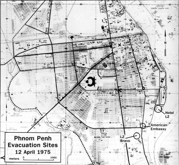
| DescriptionMap of Operation Eagle Pull evacuation sites.jpg | English: Map of possible helicopter landing zones for use in Operation Eagle Pull |
| Date | |
| Source | http://www.history.navy.mil/index.html |
| Author | US Navy |
| Public domainPublic domainfalsefalse |
This file is a work of a sailor or employee of the U.S. Navy, taken or made as part of that person's official duties. As a work of the U.S. federal government, it is in the public domain in the United States. |  | |
| This file has been identified as being free of known restrictions under copyright law, including all related and neighboring rights. | ||
https://creativecommons.org/publicdomain/mark/1.0/PDMCreative Commons Public Domain Mark 1.0falsefalse
Click on a date/time to view the file as it appeared at that time.
| Date/Time | Thumbnail | Dimensions | User | Comment | |
|---|---|---|---|---|---|
| current | 09:11, 7 February 2010 | | 600 × 552 (95 KB) | Mztourist | {{Information |Description={{en|1=Map of possible helicopter landing zones for use in Operation Eagle Pull}} |Source=http://www.history.navy.mil/index.html |Author=US Navy |Date=1975-04 |Permission= |other_versions= }} Category:Operation Eagle Pull [ |
The following other wikis use this file:
This file contains additional information, probably added from the digital camera or scanner used to create or digitize it.
If the file has been modified from its original state, some details may not fully reflect the modified file.
| _error | 0 |
|---|