

Choân kái-sek-tō͘ (910 × 675 siōng-sò͘ , tóng-àn chiàm-liōng: 307 KB, MIME luī-hêng: image/png)
| | Che sī tùi Wikimedia Commons ín--lâi ê chi̍t hūn tóng-àn. I tī hia ê kì-su̍t-ia̍h téng-bīn ê chu-sìn hián-sī ùi ē-té. |
The factual accuracy of 此地圖 or the file name is disputed. Reason: Uploader used the book "The Taiping Heavenly Kingdom: Rebellion and the Blasphemy of Empire" by Thomas H. Reilly as reference but the map presented show different territories during early 1854 and early 1862. The map is a bit confusing and the uploader probably thought the territory of 1854 also included the territory of 1862. Even if it was right, there are lots of wrongly drawn areas. Discussion and further explanation can be found here. |  |
The factual accuracy of 此地圖 or the file name is disputed. Reason: South China Sea dispute/Nine-Dash Line- replace with zh:File:Qing Dynasty 1820.png | |
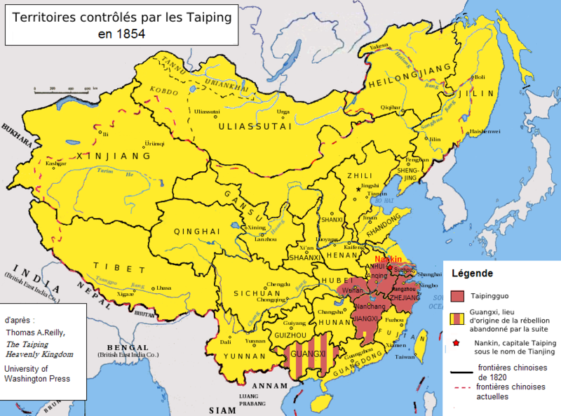
| Soat-bêngTaiping2.PNG | Français : Extension de la révolte des Taiping. (Français) English: Extent of the Taiping Rebellion (French). Tiếng Việt: Vùng kiểm soát của quân Thái Bình Thiên Quốc (tiếng Pháp). 中文:紅色為太平天國的勢力範圍 (法文) |
| Ji̍t-kî | |
| Chhut-chhù | File:Qing Dynasty 1820.png |
| Chok-chiá | Zolo |
| 其他版本 |
|
 | 已授權您依據自由軟體基金會發行的無固定段落、封面文字和封底文字GNU自由文件授權條款1.2版或任意後續版本,對本檔進行複製、傳播和/或修改。該協議的副本列在GNU自由文件授權條款中。http://www.gnu.org/copyleft/fdl.htmlGFDLGNU Free Documentation Licensetruetrue |
Chhi̍h ji̍t-kî/sî-kan, khoàⁿ hit sî-chūn--ê tóng-àn.
| Ji̍t-kî/Sî-kan | 細張圖 | 寸尺 | Iōng-chiá | Chù-kái | |
|---|---|---|---|---|---|
| hiān-chāi | 2008-nî 10-goe̍h 31-ji̍t (pài-gō·) 07:56 | | 910 × 675(307 KB) | Zolo | {{Information |Description={{en|1=Territoire sous contrôle Taiping en 1854}} |Source=Own work by uploader |Author=Zolo |Date=30th Oct 2009 |Permission= |other_versions= }} <!--{{ImageUpload|full}}--> Category:Maps of China |
Í-hā ê ia̍h liân kàu chit ê iáⁿ-siōng:
Ē-kha--ê kî-thaⁿ wiki ēng tio̍h chit--ê tóng-àn:

.png)
