파일:SPSM.05.jpg

원본 파일 (2,756 × 2,000 픽셀, 파일 크기: 3.99 MB, MIME 종류: image/jpeg)
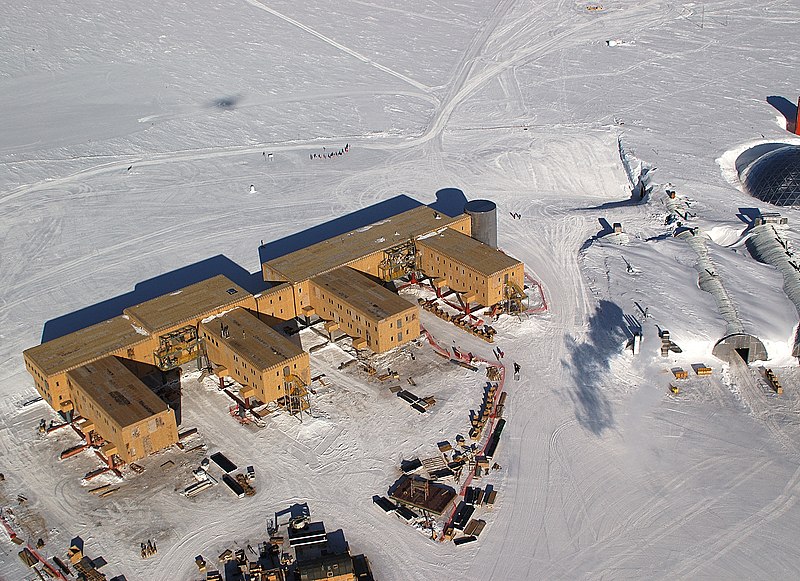
| 설명 | English: Buildings (Amundsen-Scott South Pole Station pictured) under construction. They have to be built on stilts at the South Pole to prevent snow buildup. The ceremonial pole and flags can be seen in the background, slightly to the left of center, below the tracks behind the buildings. The actual geographic pole is a few more metres to the left.Flags and pole are more visible in en:Image:Amundsen-scott-south pole station 2006.jpg and en:Image:Ceremonial South Pole.jpg.
| |||
| 날짜 | ||||
| 출처 | U.S. Antarctic Program, National Science Foundation, image SPSM.05.5.JPG. | |||
| 저자 | Bill Henriksen, National Science Foundation | |||
| 저작권 (이 파일을 인용하기) |
|

기존 올리기 기록
This image was originally uploaded at the English Wikipedia.
(All user names refer to en.wikipedia)
- 2006-03-09 16:46 Rebroad 2756×2000×8 (4188033 bytes)
파일 역사
날짜/시간 링크를 클릭하면 해당 시간의 파일을 볼 수 있습니다.
| 날짜/시간 | 섬네일 | 크기 | 사용자 | 설명 | |
|---|---|---|---|---|---|
| 현재 | 2007년 3월월 28일 (수) 07:03 | | 2,756 × 2,000 (3.99 MB) | Evrik | {{Information |Description=Buildings (en:Amundsen-Scott South Pole Station pictured) have to be built on en:stilts at the en:South Pole to prevent en:snow buildup. The ceremonial pole and flags can be seen in the background, slightly t |
이 파일을 사용하는 문서
다음 문서 1개가 이 파일을 사용하고 있습니다:
이 파일을 사용하고 있는 모든 위키의 문서 목록
다음 위키에서 이 파일을 사용하고 있습니다:
- af.wikipedia.org에서 이 파일을 사용하고 있는 문서 목록
- als.wikipedia.org에서 이 파일을 사용하고 있는 문서 목록
- ar.wikipedia.org에서 이 파일을 사용하고 있는 문서 목록
- az.wikipedia.org에서 이 파일을 사용하고 있는 문서 목록
- ba.wikipedia.org에서 이 파일을 사용하고 있는 문서 목록
- be.wikipedia.org에서 이 파일을 사용하고 있는 문서 목록
- bg.wikipedia.org에서 이 파일을 사용하고 있는 문서 목록
- ca.wikipedia.org에서 이 파일을 사용하고 있는 문서 목록
- ceb.wikipedia.org에서 이 파일을 사용하고 있는 문서 목록
- cs.wikipedia.org에서 이 파일을 사용하고 있는 문서 목록
- cv.wikipedia.org에서 이 파일을 사용하고 있는 문서 목록
- cy.wikipedia.org에서 이 파일을 사용하고 있는 문서 목록
- da.wikipedia.org에서 이 파일을 사용하고 있는 문서 목록
- de.wikipedia.org에서 이 파일을 사용하고 있는 문서 목록
- de.wikivoyage.org에서 이 파일을 사용하고 있는 문서 목록
- en.wikipedia.org에서 이 파일을 사용하고 있는 문서 목록
- en.wikivoyage.org에서 이 파일을 사용하고 있는 문서 목록
- eo.wikipedia.org에서 이 파일을 사용하고 있는 문서 목록
- es.wikipedia.org에서 이 파일을 사용하고 있는 문서 목록
- et.wikipedia.org에서 이 파일을 사용하고 있는 문서 목록
이 파일의 더 많은 사용 내역을 봅니다.