Bestand:GOF Photo.jpg

Grootte van deze voorvertoning: 800 × 600 pixels. Andere resoluties: 320 × 240 pixels | 640 × 480 pixels | 1.024 × 768 pixels | 1.200 × 900 pixels.
Oorspronkelijk bestand (1.200 × 900 pixels, bestandsgrootte: 189 kB, MIME-type: image/jpeg)
| Dit is een bestand van Wikimedia Commons. Onderstaande beschrijving komt van de beschrijving van het bestand daar. |
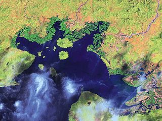
| Beschrijving | English: Satellite Image of the Gulf of Fonseca Español: Imagen de satélite del Golfo de Fonseca |
| Datum | |
| Bron | National Oceanic and Atmospheric Administration |
| Auteur | NOAA |
| Andere versies |

Licentie
Deze afbeelding is in het publiek domein omdat het materiaal bevat dat oorspronkelijk van de National Oceanic and Atmospheric Administration kwam in de Verenigde Staten en genomen of gemaakt is tijdens de officiële werkzaamheden van een werknemer. |
Oorspronkelijk uploadlogboek
De oorspronkelijke beschrijving van deze afbeelding stond hier. Alle volgende gebruikersnamen verwijzen naar en.wikipedia.
- 2008-01-31 19:23 Mwilburn38 1200×900× (193791 bytes) {{Information |Description=Satellite Image of the Gulf of Fonseca |Source=National Oceanic and Atmospheric Administration |Date=2001 |Location=http://www.noaa.gov |Author=NOAA |Permission= |other_versions= }}
Bestandsgeschiedenis
Klik op een datum/tijd om het bestand te zien zoals het destijds was.
| Datum/tijd | Miniatuur | Afmetingen | Gebruiker | Opmerking | |
|---|---|---|---|---|---|
| huidige versie | 5 apr 2010 16:38 | | 1.200 × 900 (189 kB) | Urdangaray | {{Information |Description={{en|Satellite Image of the Gulf of Fonseca}} |Source=Transferred from [http://en.wikipedia.org en.wikipedia]<br/> (Original text : ''National Oceanic and Atmospheric Administration'') |Date=2001<br/> ({{Date|2008|01|31}} (origi |
Bestandsgebruik
Dit bestand wordt op de volgende 2 pagina's gebruikt:
Globaal bestandsgebruik
De volgende andere wiki's gebruiken dit bestand:
- Gebruikt op ar.wikipedia.org
- Gebruikt op ast.wikipedia.org
- Gebruikt op bg.wikipedia.org
- Gebruikt op ca.wikipedia.org
- Gebruikt op ceb.wikipedia.org
- Gebruikt op cs.wikipedia.org
- Gebruikt op de.wikipedia.org
- Gebruikt op en.wikipedia.org
- Gebruikt op eo.wikipedia.org
- Gebruikt op es.wikipedia.org
- Gebruikt op eu.wikipedia.org
- Gebruikt op fa.wikipedia.org
- Gebruikt op fi.wikipedia.org
- Gebruikt op fr.wikipedia.org
- Gebruikt op gl.wikipedia.org
- Gebruikt op hr.wikipedia.org
- Gebruikt op hy.wikipedia.org
- Gebruikt op id.wikipedia.org
- Gebruikt op ilo.wikipedia.org
- Gebruikt op it.wikipedia.org
- Gebruikt op ja.wikipedia.org
- Gebruikt op kk.wikipedia.org
- Gebruikt op ko.wikipedia.org
- Gebruikt op mk.wikipedia.org
- Gebruikt op mr.wikipedia.org
- Gebruikt op mt.wikipedia.org
- Gebruikt op nn.wikipedia.org
- Gebruikt op no.wikipedia.org
- Gebruikt op pa.wikipedia.org
- Gebruikt op pl.wikipedia.org
- Gebruikt op pnb.wikipedia.org
- Gebruikt op pt.wikipedia.org
- Gebruikt op ru.wikipedia.org
Globaal gebruik van dit bestand bekijken.
Metadata
🔥 Top keywords: HoofdpaginaSpeciaal:ZoekenRonald PlasterkRichard van ZwolLoiza LamersChatGPTJoost KleinExtreemrechtsPinksterenRode dieselGeert WildersNieuw-Caledonië (gebiedsdeel)Dilan YeşilgözSpecial:MyPage/zeusmodepreferences.jsLelylijnHenk VermeerRobert FicoElbert DijkgraafBaby ReindeerSpreidingswetBram van PolenCaroline van der PlasEuropese Parlementsverkiezingen 2024 in NederlandVinexKesbekeConstitutioneel hofBen van der BurgN-termEurovisiesongfestival 2024NederlandSpeciaal:RecenteWijzigingenLouisa JanssenIetsismeLangstudeerboeteMáxima ZorreguietaSlowakijeCleopatra VIIPatrick MoenaertBridgerton