

Oreeginal file (1,810 × 1,854 pixels, file size: 2.37 MB, MIME type: image/png)
This file is fae Wikimedia Commons n micht be uised bi ither waurks.The descreeption oan its file descreeption page thaur is shawn ablo.
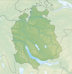
| DescreeptionReliefkarte Zürich blank.png | Deutsch: Reliefkarte des Kantons Zürich Topographischer Hintergrund: NASA Shuttle Radar Topography Mission (public domain). SRTM3 v.2. | ||||||||
| Date | |||||||||
| Soorce | Ain wirk | ||||||||
| Author | Tschubby | ||||||||
| Permission (Reuisin this file) | I, the copyright holder of this work, hereby publish it under the following licenses:
This file is licensed under the Creative Commons Attribution-Share Alike 2.5 Generic, 2.0 Generic and 1.0 Generic license.
Ye mey select the license o yer choice. | ||||||||
| Other versions |  |
Clap oan ae date/time fer tae see the file aes it kithed at that time.
| Date/Time | Thummnail | Dimensions | Uiser | Comment | |
|---|---|---|---|---|---|
| current | 09:36, 13 Juin 2014 | | 1,810 × 1,854 (2.37 MB) | Tschubby | {{Information |Description= |Source= |Date= |Author= |Permission= |other_versions= }} |
| 12:54, 6 December 2013 |  | 1,813 × 1,855 (3.35 MB) | Tschubby | {{Information |Description= {{de| Reliefkarte des Kantons Zürich}} Topographischer Hintergrund: [http://www2.jpl.nasa.gov/srtm NASA Shuttle Radar Topography Mission] (public domain). SRTM3 v.2. |Source={{own}} |Date= 2013-12-06 |Author= [[:de:User:Tsc... |
The follaein ither wikis uise this file:
View mair global usage o this file.
This file contains addeetional information, likelie eikit fae the deegital camera or scanner uised tae cræft or deegitise it.
Gif the file haes bin modeefied fae its oreeginal state, some details micht na fullie reflect the modeefied file.
| Horizontal resolution | 118.11 dpc |
|---|---|
| Verteecal resolution | 118.11 dpc |
