Kalbajar
- For the admeenistrative destrict, see Kalbajar Rayon.
Kalbajar (Armenie: Քարվաճառ, spelt as Karvachar, Azerbaijani: Kəlbəcər, spelt as Kelbajar, Kälbäjär, Kelbadzhar, Kelbadshar, Kelbadjar, an Kelbadžar an aw) is the admeenistrative centre o Kalbajar Rayon o Azerbaijan. The ceety alang wi the associatit rayon is unner the control o the unrecognizit Nagorno-Karabakh Republic efter it wis captured bi Armenie forces durin the Battle o Kalbajar, near the end o the Nagorno-Karabakh War.[1]
Kalbajar/Karvachar Քարվաճառ | |
|---|---|
 Coat airms | |
 Kalbajar/Karvachar | |
| Coordinates: 40°06′24″N 46°02′18″E / 40.10667°N 46.03833°E 46°02′18″E / 40.10667°N 46.03833°E | |
| Kintra | De-facto De-jure |
| NKR Province Azerbaijani Rayon | Kalbajar |
| Population (2005) | |
| • Total | 491 |
| Time zone | UTC+4 (AZT) |
Nagorno-Karabakh War
Armenie an Karabakh forces conquered Kalbajar the Nagorno-Karabakh War, due tae its strategic location atween the umwhile Nagorno-Karabakh Autonomous Oblast an Armenie.[2] Human Rights Watch fyndins concludit that durin the Kelbajar affensive Armenie forces "committit several violations o the rules o war, includin forcit displacement o the civilian population, indiscriminate fire, an the takkin o hostages."[3] This captur wis condemned bi the UN Security Cooncil.[1]
Lakes, rivers, muntains an zones
Thare are 13 lakes in local plains an muntains. Karvachar’s langest river is the Tartar. Its tributaries are the Tutkhun, Lev, Zaylik, Alolar, Garaarkhaj (Sarkar) rivers. Thare are 20 well-kent watter springs an aw. 70-80 per cent o the destrict is made up o muntains an each o them haes a name. Syne motor traffeck in muntains is limitit, local fowk hae dividit the destrict in different zones:1. Upper zone – territories stretchin frae the centre wastwairds 2. Ayrim zone – north-wast 3. Gamishli-Lev zone – north-east 4. Tutgu zone – aurie aroond Zulfugarli- Baslibel 5. Sarsang SES zone – forests in the east 6. The Dalidagh-Sariyer-Keyti zone consists o bare muntains an plains
Gallery
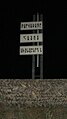 Sign at northren steid o the ceety wi Armenie text: "Karvajar is an Armenie fortress".
 The main street o the ceety.
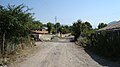 Ither ceety street.
 Childer playin fitbaa in the ceety.

.jpg)


References
Freemit airtins
- Kalbajar at GEOnet Names Server
- World Gazetteer: Azerbaijan[deid airtin] – Warld-Gazetteer.com
- Azerbaijan Development Gateway