Mulegé Municipality
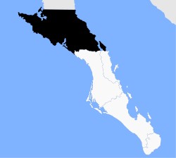
Mulegé is the northmaist municipality o the Mexican state o Baja California Sur. It is the seicont-lairgest (ahint anerlie Ensenada) municipality bi aurie in the kintra, wi an aurie o 32,092.2 km² (12,777 sq mi). In the census o 2010 it haed a population o 59,114 indwallers. Isla Natividad is pairt o the municipality.
Mulegé | |
|---|---|
 Location o Mulegé in Baja California Sur. | |
| Kintra | Mexico |
| State | Baja California Sur |
| Municipal seat | Santa Rosalía |
| Lairgest ceety | Guerrero Negro |
| Population (2010) | |
| • Total | 59,114 |
| Time zone | UTC−7 (MST) |
| • Summer (DST) | UTC−6 (MDT) |
The municipal seat is locatit in Santa Rosalía.
Thare is an initiative tae split the municipality intae twa, wi the division alang the rig dividin the current municipality, sae that the Pacific side, which includes its lairgest ceety, Guerrero Negro, an an aa Villa Alberto Andrés Alvarado Arámburo, wad be separated frae the Gulf o California side, which includes Santa Rosalía an Mulegé.
Subdiveesions
Includin the municipal seat o Santa Rosalía, the municipality is subdividit intae sax delegaciones:
- Santa Rosalía
- Bahía Tortugas
- Guerrero Negro
- Mulegé
- San Ignacio
- Vizcaíno
Commonties
The census o 2010 leets 459 populatit places, o which 90 haed a population o 10 or mair, an 38 o 100 or mair. Those o 500 or mair are leetit belaw:
| Name | 2010 Census Population |
|---|---|
| Guerrero Negro | 13,054 |
| Santa Rosalía | 11,765 |
| Villa Alberto Andrés Alvarado Arámburo | 6,902 |
| Heroica Mulegé | 3,821 |
| Bahía Tortugas | 2,671 |
| San Francisco | 2,152 |
| Las Margaritas | 1,595 |
| Bahía Asunción | 1,484 |
| El Silencio | 1,190 |
| Gustavo Díaz Ordaz | 969 |
| Estero de la Bocana | 967 |
| Punta Abreojos | 788 |
| San Ignacio | 667 |
| Los Mártires | 651 |
| San Bruno | 623 |
| Ejido San Lucas | 606 |
| Tot Municipality | 59,114 |
References
- 2010 census tables: INEGI Archived 2018-12-25 at the Wayback Machine: Instituto Nacional de Estadística, Geografia e Informática (INEGI)
- Los 20 Municipios Más Extensos Archived 2013-10-17 at the Wayback Machine Instituto Nacional Para el Federalismo y el Desarrollo Municipal
