Файл:Stalingrad - Preparations for Operation Uranus.png
Розмір при попередньому перегляді: 800 × 492 пікселів. Інші роздільності: 320 × 197 пікселів | 640 × 394 пікселів | 1024 × 630 пікселів | 1280 × 788 пікселів | 2560 × 1576 пікселів | 4321 × 2660 пікселів.
Повна роздільність (4321 × 2660 пікселів, розмір файлу: 2,83 МБ, MIME-тип: image/png)
| Відомості про цей файл містяться на Вікісховищі — централізованому сховищі вільних файлів мультимедіа для використання у проектах Фонду Вікімедіа. |
 | Ця мапа має бути конвертована у векторний формат SVG. Це дає декілька переваг, докладніше про які Ви можете прочитати на сторінці Commons:Media for cleanup. Якщо Вам вже зараз доступна векторна версія даного зображення, завантажте її, будь ласка. Після завантаження замініть цей шаблон на такий: {{vector version available|Назва_завантаженого_файлу.svg}}. |
Опис файлу
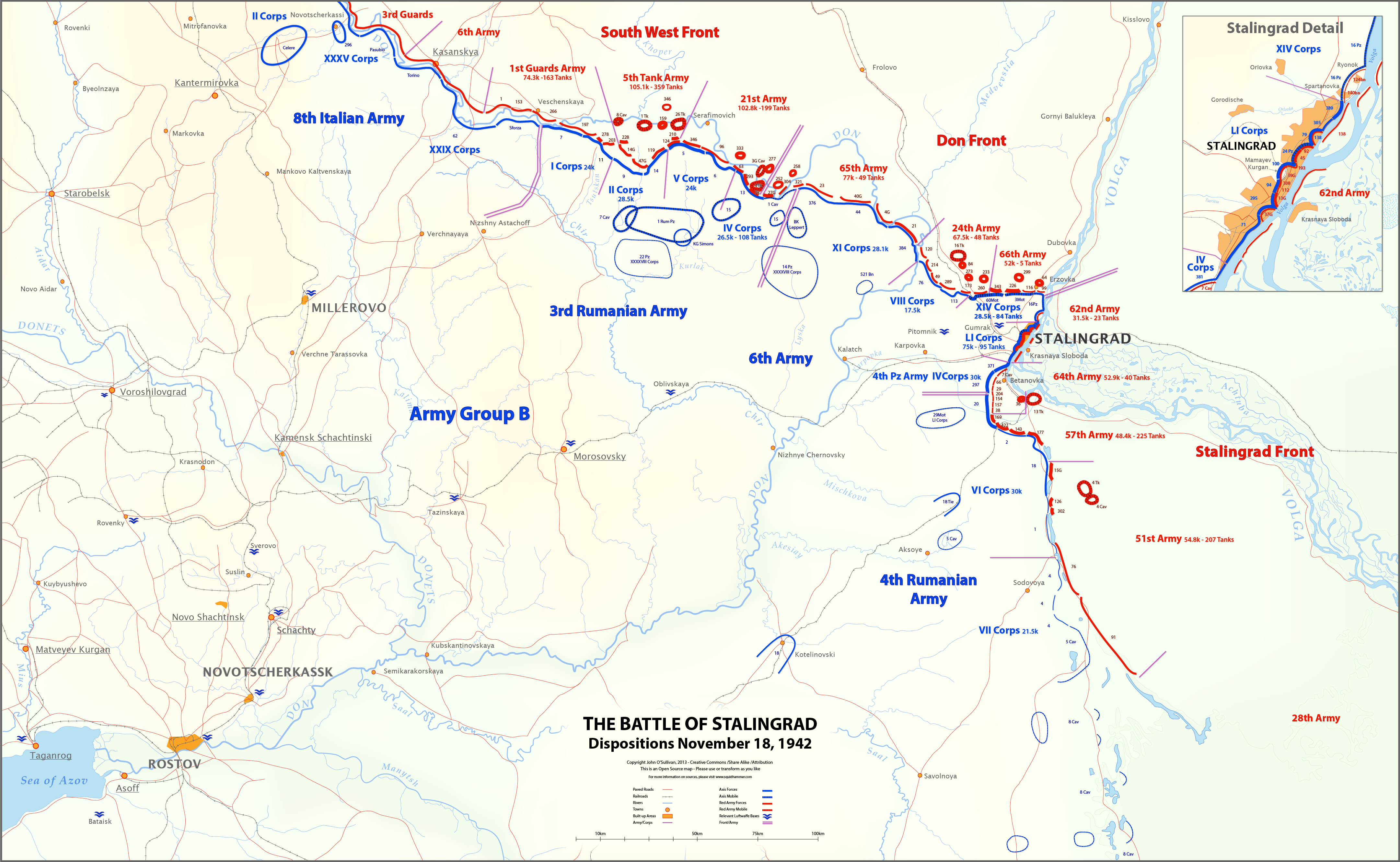
| Опис | English: This map shows unit locations and relative strengths for Axis and Soviet Armies on Nov 18, 1942, during the Battle of Stalingrad.On November 19, the Soviets launched Operation Uranus, an offensive designed to isolate and destroy the German 6th Army at Stalingrad. |
| Час створення | |
| Джерело | Власна робота |
| Автор | Josullivan.59 |
| Інші версії |  |
Sources:
Books and Articles
| Author | Title | Notes |
| Alexei V. Isaev | Stalingrad: The Volga No Land For Us | Soviet forces and tanks |
| Antony Beevor | Stalingrad-The-Fateful-Siege-1942-1943 | Most widely cited Order of Battle |
| Wikipedia | Red Army Order of Battle Stalingrad | Useful |
| Wikipedia | Axis order of battle at the Battle of Stalingrad | Not particularly useful |
| Staldata | Staldata | Axis and Soviet Orders of Battle & force strength |
| Wolf Höpper | Against the Flood - Operation Uranus (I) | German tank numbers |
| Joel S. A. Hayward | Stopped At Stalingrad: The Luftwaffe And Hitler's Defeat In The East 1942-1943 | Bases used for Airlift |
| Akhil Kadidal | Stalingrad Pocket | Really good maps and annotated photographs |
Maps
| Title | Source | Notes |
| OKH Situation Map Nov 18 42 | WW2 Photos Maps | Axis forces locations Fantastic Site! |
| OKH Situation Map Nov 18 42 2 | WW2 Photos Maps | Axis forces locations Fantastic Site! |
| S4231 Summary of combat operations in Stalingrad | Armchair General/RIIAWW2 | Red Army locations Excellent map |
| S4239 Operations in Stalingrad area | RIIAWW2 Armchair General/RIIAWW2 | Red Army locations |
| S4251 Combat operations of the South-Western, Don and Stalingrad Fronts | Armchair General/RIIAWW2 | Red Army locations |
Notes:
- My Order of Battle is here.
- There are more units listed in the Order of Battle than appear on the map. I didn't place any unit on the map unless I could find it in one of the source maps.
- In conflicts between locations on the OKH map and the Soviet maps, I used the Soviet map. The Germans had not picked up the Uranus build-up, so the Soviets had much better intelligence at this time.
- I could find no information on the strength of the 8th Italian Army, or Soviet 6th and 3rd Guards Armies.
- Unit lines are thicker or thinner based on strength and density. These are characterizations, not precise measurements.
- Unit strengths are shown in the layers in the SVG version of the map. These are based on the Order of Battle spreadsheet linked above. The spreadsheet includes notes on the units shown on the map.
- The base map is derived from the OKH maps. I do not know the map projection.
- Please feel free to comment on any inaccuracies! You can help to make the map better. I'm particularly interested in proper place-names.
- Ви можете вільно:
- ділитися – копіювати, поширювати і передавати твір
- модифікувати – переробляти твір
- При дотриманні таких умов:
- зазначення авторства – Ви повинні вказати авторство, надати посилання на ліцензію і вказати, чи якісь зміни було внесено до оригінального твору. Ви можете зробити це в будь-який розсудливий спосіб, але так, щоб він жодним чином не натякав на те, наче ліцензіар підтримує Вас чи Ваш спосіб використання твору.
- поширення на тих же умовах – Якщо ви змінюєте, перетворюєте або створюєте іншу похідну роботу на основі цього твору, ви можете поширювати отриманий у результаті твір тільки на умовах такої ж або сумісної ліцензії.
Ліцензування
Я, власник авторських прав на цей твір, добровільно публікую його на умовах такої ліцензії:
Цей файл ліцензований на умовах Creative Commons Attribution-Share Alike 3.0 Unported
Історія файлу
Клацніть на дату/час, щоб переглянути, як тоді виглядав файл.
| Дата/час | Мініатюра | Розмір об'єкта | Користувач | Коментар | |
|---|---|---|---|---|---|
| поточний | 18:27, 12 березня 2013 | | 4321 × 2660 (2,83 МБ) | Josullivan.59 | Fixed the licensing information on the map. |
| 18:13, 12 березня 2013 |  | 4322 × 2660 (3,89 МБ) | Josullivan.59 | User created page with UploadWizard |
Використання файлу
Така сторінка використовує цей файл:
Глобальне використання файлу
Цей файл використовують такі інші вікі:
- Використання в de.wikipedia.org
- Використання в en.wikipedia.org
- Використання в es.wikipedia.org
- Використання в fi.wikipedia.org
- Використання в fr.wikipedia.org
- Використання в ja.wikipedia.org
- Використання в no.wikipedia.org
- Використання в pt.wikipedia.org
Метадані
🔥 Top keywords: Головна сторінкаФайл:XHamster logo.svgДень вишиванкиPorno for PyrosСпеціальна:ПошукВишиванкаЮрай ЦинтулаНова КаледоніяВовчанськУсик Олександр ОлександровичТайсон Ф'юріУкраїнаТериторіальний центр комплектування та соціальної підтримкиФайл:XVideos logo.svgРоберт ФіцоYouTubeБудинок «Слово»Nemo (співак)МіГ-31БріджертониВійськово-облікова спеціальністьПісенний конкурс Євробачення 2024Всесвітній день вишиванкиТайсон Ф'юрі — Олександр УсикНебінарний гендерБудинок «Слово» (фільм, 2021)Микола ХвильовийFacebook125-та окрема бригада територіальної оборони (Україна)Шевченко Тарас ГригоровичПриродні заповідники УкраїниТварини Червоної книги УкраїниРосійське вторгнення в Україну (з 2022)Марко ВовчокСкуфЛеся УкраїнкаРослини Червоної книги УкраїниРозстріляне відродженняВійськові звання України