Tập tin:Crops Kansas AST 20010624.jpg

Kích thước hình xem trước: 626×600 điểm ảnh. Độ phân giải khác: 250×240 điểm ảnh | 501×480 điểm ảnh | 801×768 điểm ảnh | 1.069×1.024 điểm ảnh | 2.137×2.048 điểm ảnh | 2.589×2.481 điểm ảnh.
Tập tin gốc (2.589×2.481 điểm ảnh, kích thước tập tin: 1,33 MB, kiểu MIME: image/jpeg)
|

Miêu tả
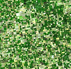
| Miêu tả | English: Satellite image of crops growing in Kansas, United States. Healthy, growing crops are green. Corn would be growing into leafy stalks by late June (when this photo was taken). Sorghum, which resembles corn, grows more slowly and would be much smaller and therefore, possibly paler. Wheat is a brilliant gold as harvest occurs in June. Fields of brown have been recently harvested and plowed under or lie fallow for the year. The circular crop fields are a characteristic of center pivot irrigation. The fields shown here are 800 and 1,600 meters (0.5 and 1 mile) in diameter. The image is centered near Sublette, Kansas at about 37.5 degrees north latitude, 100.75 degrees west longitude, and covers an area of 37.2 x 38.8 km. The 'grid' in which the fields are laid out runs north-south/west-east and the dark angled line is U.S. Route 56.The image is aligned with the satellite orbital track, which is in a 98 degrees tilted orbit. North is about 10 degrees counter-clockwise from up. The image is a false-color presentation made to simulate natural color. The 3 bands that were used are in the green, red, and near infrared parts of the spectrum. ASTER does not have a blue channel, so any blue that can be seen was created from the other bands. Français : Image satellitaire de cultures poussant au Kansas (Etats Unis) à la fin du mois de juin. Les cultures en pleines croissance comme le maïs sont représentées en vert. Le Sorgho, moins avancé en cette saison, est plus pâle. Le blé est déjà doré et sera bientôt récolté. Les parcelles brunes ont déjà été moissonnées ou sont en jachère. La forme circulaire des champs est typique de l'irrigation à pivot central. Le diamètre de ces champs est souvent de 800 ou 1600 mètres, ils sont inscrits dans les "sections" de 1 mile américain de côté héritées du Public Land Survey System (article en Anglais). La ligne oblique qui traverse l'image est la Route Fédérale 56.L'image est alignée sur l'orbite du satellite ASTER de la NASA qui a pris la photo. Cette orbite est inclinée de 98 degrés par rapport à l'axe des pôles. Le nord est vers le haut, mais il fait un angle de 10 degrés dans le sens inverse des aiguilles d'une montre. L'image est en fausse couleurs, simulant les couleurs naturelles. Les trois longueurs d'ondes observées correspondent au vert, au rouge, et au proche infrarouge. Deutsch: Ein Satellitenbild von Anbaufeldern in Kansas, Vereinigte Staaten. Gesunde und wachsende Pflanzen sind grün. Mais bildet Ende Juni (als dieses Foto aufgenommen wurde) belaubte Stängel aus. Hirse sieht Mais ähnlich, wächst langsamer, ist viel kleiner und daher möglicherweise blasser. Weizen ist leuchtend gold, wenn im Juni die Ernte beginnt. Braune Felder wurden vor kurzem abgeerntet und umgegraben oder liegen in diesem Jahr brach. Die kreisrunden Felder sind charakteristisch für eine Bewässerung durch Kreisberegnung. Die gezeigten Felder besitzen einen Durchmesser von 800 und 1,600 Metern (1/2 und 1 Meile). Das Bild ist bei etwa 37,5 Grad nördlicher Breite und 100,75 Grad westlicher Länge zentriert und deckt ein Gebiet von 37,2 x 38,8 km ab. Das 'Gitter', in dem die Felder angelegt sind, verläuft in Nord/Süd- und West/Ost-Richtung. Die schräge dunkle Linie ist die U.S Route 56.Das Bild ist an die Satellitenbahn ausgerichtet, die einen Winkel von 98 Grad aufweist. Norden befindet sich etwa 10 Grad gegen den Uhrzeigersinn gedreht. Das Bild zeigt eine Falschfarbendarstellung, die natürliche Farben simulieren soll. Die drei verwendeten Bänder befinden sich im Grün-, im Rot- und nahe dem Infrarotbereich des Spektrums. Das Radiometer ASTER besitzt keinen Blaukanal, und daher wurde die sichtbare blaue Farbe von den anderen Bändern erzeugt. Čeština: Satelitní snímek zemědělské krajiny v Kansasu v USA. Zdravé, rostoucí plodiny jsou zelené. Snímek byl pořízen koncem června, kdy kukuřice už je zelená, ale čirok, který roste pomaleji a je mnohem menší, je bledší. Pšenice je zářivě zlatá, protože je právě před její sklizní. Hnědá pole jsou už sklizená a zaoraná, případně byla ponechána ladem. Kruhová pole jsou charakteristická pro závlažování s pivotem. Zobrazená pole mají 800 a 1600 m v průměru. Střed obrázku zachycuje oblast okolo 37,5° severní šířky a 100,75° západní délky. Fotografie pokrývá oblast 37,2 × 38,8 km. Mřížka polí je orientována severojižně/západovýchodně. Tmavá šikmá čára je U.S. Route 56.Fotografie je natočená podél oběžné dráhy satelitu, která má sklon 98°. Sever je asi 10° proti směru chodu hodinových ručiček od směru nahoru. Obrázek je ve falešných barvách simulujících přirozené zabarvení. Byl pořízen ve třech kanálech: zeleném červeném a blízkém infračerveném. ASTER nemá modrý kanál, proto cokoli modrého je na této fotografii složeno z ostatních kanálů. العربية: صورةُ الأقمار الصناعيّة لحقول محاصيل دائرية في مقاطعة هاكسيل كانزاس في آخر شهر حزيران/يونيو 2001. المحاصيل الصحية، التي تنمو من ذرة سورغم لونها أخضر (قد يكون السورغم شاحبًا قليلًا،)، بينما القمحُ ذهبيٌّ لامع. | |||||
| Ngày | ||||||
| Nguồn gốc | http://earthobservatory.nasa.gov/Newsroom/NewImages/images.php3?img_id=17006 | |||||
| Tác giả | NASA | |||||
| Giấy phép (Dùng lại tập tin) |
|

| Vị trí máy chụp hình | | Xem hình này và các hình ảnh lân cận trên: OpenStreetMap |
|---|
Lịch sử tập tin
Nhấn vào ngày/giờ để xem nội dung tập tin tại thời điểm đó.
| Ngày/giờ | Hình xem trước | Kích cỡ | Thành viên | Miêu tả | |
|---|---|---|---|---|---|
| hiện tại | 17:01, ngày 8 tháng 5 năm 2006 | | 2.589×2.481 (1,33 MB) | Holly Cheng | {{Information | Description=Satellite image of crops growing in Kansas, USA. Healthy, growing crops are green. Corn would be growing into leafy stalks by late June (when this photo was taken). Sorghum, which resembles corn, grows more slowly and would be |
Trang sử dụng tập tin
Có 2 trang tại Wikipedia tiếng Việt có liên kết đến tập tin (không hiển thị trang ở các dự án khác):
Sử dụng tập tin toàn cục
Những wiki sau đang sử dụng tập tin này:
- Trang sử dụng tại af.wikipedia.org
- Trang sử dụng tại als.wikipedia.org
- Trang sử dụng tại ar.wikipedia.org
- Trang sử dụng tại ast.wikipedia.org
- Trang sử dụng tại ba.wikipedia.org
- Trang sử dụng tại bh.wikipedia.org
- Trang sử dụng tại bn.wikipedia.org
- Trang sử dụng tại bxr.wikipedia.org
- Trang sử dụng tại ca.wikipedia.org
- Trang sử dụng tại ckb.wikipedia.org
- Trang sử dụng tại cs.wikipedia.org
- Trang sử dụng tại da.wikipedia.org
- Trang sử dụng tại de.wikipedia.org
- Trang sử dụng tại el.wikipedia.org
- Trang sử dụng tại en.wikipedia.org
Xem thêm các trang toàn cục sử dụng tập tin này.
🔥 Top keywords: Đài Truyền hình Kỹ thuật số VTCTrang ChínhGiỗ Tổ Hùng VươngTrương Mỹ LanĐặc biệt:Tìm kiếmHùng VươngVương Đình HuệUEFA Champions LeagueKuwaitChiến dịch Điện Biên PhủFacebookĐài Truyền hình Việt NamTrần Cẩm TúĐội tuyển bóng đá quốc gia KuwaitGoogle DịchViệt NamCúp bóng đá U-23 châu ÁCúp bóng đá U-23 châu Á 2024Real Madrid CFBảng xếp hạng bóng đá nam FIFACleopatra VIITô LâmTim CookNguyễn Phú TrọngHồ Chí MinhHai Bà TrưngManchester City F.C.VnExpressChủ tịch nước Cộng hòa xã hội chủ nghĩa Việt NamNguyễn Ngọc ThắngĐền HùngCúp bóng đá trong nhà châu Á 2024Võ Văn ThưởngOne PieceLịch sử Việt NamCuộc đua xe đạp toàn quốc tranh Cúp truyền hình Thành phố Hồ Chí Minh 2024Phạm Minh ChínhTikTokĐinh Tiên Hoàng