Tập tin:Rzeczpospolita 1923.png

Tập tin gốc (2.000×1.534 điểm ảnh, kích thước tập tin: 346 kB, kiểu MIME: image/png)
 | Hiện có một phiên bản với định dạng vector của hình này (SVG). Nên sử dụng nó thay cho hình raster này khi cần nó chi tiết hơn. File:Rzeczpospolita 1923.png → File:Rzeczpospolita 1938.svg Để biết thêm thông tin về đồ họa vector, mời đọc về Chuyển sang SVG của Commons. Cũng có thông tin về sự hỗ trợ hình ảnh SVG của MediaWiki. |  |
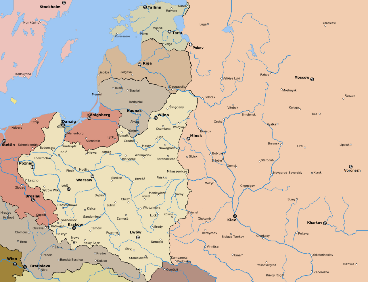
Early version of my map of Poland and Eastern Europe between 1918 and 1945. So far it features the borders and major towns and cities, as well as the frontlines of the Polish-Bolshevik War.
The colours and fonts and other stuff will be added soon.
Based on my maps of the Polish-Lithuanian Commonwealth series, colours stolen from some German map printed in 1938
The following is a list of maps created by Halibutt and uploaded to commons, as well as their present and projected derivatives.
| Parent Image | Image | Description | |||||||||||
|---|---|---|---|---|---|---|---|---|---|---|---|---|---|
| Maps by Halibutt | |||||||||||||
| Image:Rzeczpospolita.png | Image:Rzeczpospolita.png | The Republic in 17th and 18th century | |||||||||||
| Image:Rzeczpospolita 1600.png | The Republic after the Treaty of Dywilino | ||||||||||||
| Image:Rzeczpospolita voivodships.png | Voivodships of The Republic | ||||||||||||
| Image:Rzeczpospolita_Potop.png | The Republic during The Deluge and Chmielnicki Uprising, with major battles of the era marked | ||||||||||||
| Magnates and their lands and domains | |||||||||||||
| 1st • 2nd • 3rd | Partitions of Poland | ||||||||||||
| War of the constitution | |||||||||||||
| Image:Rzeczpospolita.xcf | SOURCE FILE - GIMP format | ||||||||||||
| Image:Poland 1939.png | Image:Poland 1939.png | Poland in 1939 | |||||||||||
| Image:Dywizje wrzesien 1.png | Order of Battle on September 1st, during the Polish Defence War of 1939 | ||||||||||||
| Image:Poland 1939.xcf | SOURCE FILE - GIMP format | ||||||||||||
| Image:Polska kontur bialy.png | Image:Polska kontur bialy.png | Contour map of Poland AD 1999, for use with various locator maps | |||||||||||
| Image:Rzeczpospolita 1923.png | Image:Rzeczpospolita 1923.png | Map of Poland 1918-1939, currently under development | |||||||||||
| Image:PBW March 1919.png | Polish-Bolshevik War - fronts in March of 1919 | ||||||||||||
| Image:PBW December 1919.png | Polish-Bolshevik War - fronts in December of 1919 | ||||||||||||
| Image:PBW June 1920.png | Polish-Bolshevik War - fronts in July of 1920 | ||||||||||||
| Image:PBW August 1920.png | Polish-Bolshevik War - fronts in August of 1920 | ||||||||||||
| Polish Defence War of 1939 | |||||||||||||
| Polish areas annexed by Germany, Lithuania, Slovakia and the Soviet Union | |||||||||||||
| German concentration camps in Poland | |||||||||||||
| Curzon line | |||||||||||||
| Major battles of the Polish-Bolshevik War | |||||||||||||
| names • no names | Polish/Czechoslovak/Lithuanian/German/Ukrainian claims in 1920's | ||||||||||||
| Image:Rzeczpospolita Central Lithuania.png | Central Lithuania | ||||||||||||
| Image:Rzeczpospolita Lithuania claims.png | Central Lithuania as compared with other Lithuanian claims | ||||||||||||
| Image:Rzeczpospolita 1789-1920.png | Post-1922 borders compared with the territory of Poland before the partitions | ||||||||||||
| Warsaw Uprising and the Operation Tempest | |||||||||||||
| Poland partitioned between the Soviets and the Germans | |||||||||||||
| Image:Rzeczpospolita 1939 Polish divisions.png | Polish divisions on September 1, 1939 | ||||||||||||
| Home Army inspectorates | |||||||||||||
| Image:Rzeczpospolita 1922.xcf | SOURCE FILE - GIMP format | ||||||||||||
| Image:Rzeczpospolita 1937.svg | Vector version!!!! | layered version available on request | |||||||||||
There is an alternate version at Image:Rzeczpospolita 1920 captioned.png with country names added.
Since the legal status of the above comment has been questioned, I hereby grant anyone the right to treat it as either a standard copyright notice, invariant section, legal statement, legal advice, friendly suggestion or a mere comment, depending on his or hers own choice. |
|

Lịch sử tập tin
Nhấn vào ngày/giờ để xem nội dung tập tin tại thời điểm đó.
| Ngày/giờ | Hình xem trước | Kích cỡ | Thành viên | Miêu tả | |
|---|---|---|---|---|---|
| hiện tại | 21:24, ngày 25 tháng 3 năm 2017 | | 2.000×1.534 (346 kB) | Bogomolov.PL | corrected Tsaritsyn >>> Voronezh |
| 18:10, ngày 3 tháng 8 năm 2012 |  | 2.000×1.534 (309 kB) | Kaganer | Volgograd -> Tsaritsyn (renamed only in 1925) | |
| 15:07, ngày 24 tháng 2 năm 2010 |  | 2.000×1.534 (234 kB) | Dcoetzee | Remove watermark, pngcrush | |
| 08:35, ngày 5 tháng 12 năm 2009 |  | 2.000×1.534 (361 kB) | DJ Sturm | Correct borders, improved Estonia | |
| 14:37, ngày 16 tháng 8 năm 2009 |  | 2.000×1.534 (342 kB) | Halibutt | Reverted to version as of 06:33, 8 May 2005 (don't do this. Modify the svg version instead, without those horrible colours and copy-paste leftovers) | |
| 14:30, ngày 27 tháng 3 năm 2009 |  | 2.000×1.534 (360 kB) | DJ Sturm | Fixed borders of Estonia, Latvia, Lithuania, Soviet Union and Germany, added some towns. | |
| 06:33, ngày 8 tháng 5 năm 2005 |  | 2.000×1.534 (342 kB) | Halibutt | Reverted to earlier revision | |
| 21:41, ngày 7 tháng 5 năm 2005 |  | 2.000×1.534 (308 kB) | DeirYassin~commonswiki | Corrected borders of Latvia and Russia, Estonia and Russia according to real interwar, rather than current, borders; the Lithuanian claim is shown. | |
| 20:50, ngày 7 tháng 5 năm 2005 |  | 2.000×1.534 (308 kB) | DeirYassin~commonswiki | ||
| 20:47, ngày 7 tháng 5 năm 2005 |  | 2.000×1.534 (308 kB) | DeirYassin~commonswiki |
Trang sử dụng tập tin
Sử dụng tập tin toàn cục
Những wiki sau đang sử dụng tập tin này:
- Trang sử dụng tại az.wikipedia.org
- Trang sử dụng tại ba.wikipedia.org
- Trang sử dụng tại be-tarask.wikipedia.org
- Trang sử dụng tại be.wikipedia.org
- Trang sử dụng tại bg.wikipedia.org
- Trang sử dụng tại ca.wikipedia.org
- Trang sử dụng tại cs.wikipedia.org
- Trang sử dụng tại cv.wikipedia.org
- Trang sử dụng tại da.wikipedia.org
- Trang sử dụng tại de.wikipedia.org
- Trang sử dụng tại el.wikipedia.org
- Trang sử dụng tại en.wikipedia.org
- Trang sử dụng tại et.wikipedia.org
- Trang sử dụng tại fa.wikipedia.org
- Trang sử dụng tại fr.wikipedia.org
- Trang sử dụng tại fy.wikipedia.org
- Trang sử dụng tại he.wikipedia.org
Xem thêm các trang toàn cục sử dụng tập tin này.