Tập tin:FRYugoMap2k.jpg

Không có độ phân giải cao hơn.
FRYugoMap2k.jpg (351×378 điểm ảnh, kích thước tập tin: 116 kB, kiểu MIME: image/jpeg)
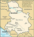
This is a map of The Federal Republic of Yugoslavia (Serbia and Montenegro) [FRY (S&M)] from as the 2000 CIA World Factbook as mirrored by the PCL.[]

 English 2000
 English 2006
 English 2006
 English 2008
 English 2008
 español 2008
 magyar 2008


This image is in the public domain because it contains materials that originally came from the United States Central Intelligence Agency's World Factbook. |  |
Lịch sử tập tin
Nhấn vào ngày/giờ để xem nội dung tập tin tại thời điểm đó.
| Ngày/giờ | Hình xem trước | Kích cỡ | Thành viên | Miêu tả | |
|---|---|---|---|---|---|
| hiện tại | 05:18, ngày 6 tháng 2 năm 2007 | | 351×378 (116 kB) | Hoshie | This is a map of The Federal Republic of Yugoslavia (Serbia and Montenegro) [FRY (S&M)] from as the [http://www.umsl.edu/services/govdocs/wofact2000/geos/sr.html 2000 CIA World Factbook] as mirrored by the [http://ww |
Trang sử dụng tập tin
Có 1 trang tại Wikipedia tiếng Việt có liên kết đến tập tin (không hiển thị trang ở các dự án khác):
Sử dụng tập tin toàn cục
Những wiki sau đang sử dụng tập tin này:
- Trang sử dụng tại en.wikipedia.org
- Trang sử dụng tại es.wikipedia.org
- Trang sử dụng tại fa.wikipedia.org
- Trang sử dụng tại fr.wikipedia.org
- Trang sử dụng tại ja.wikipedia.org
- Trang sử dụng tại kk.wikipedia.org
- Trang sử dụng tại mr.wikipedia.org
- Trang sử dụng tại nl.wikipedia.org
- Trang sử dụng tại zh.wikipedia.org
Đặc tính hình
🔥 Top keywords: Đài Truyền hình Kỹ thuật số VTCTrang ChínhGiỗ Tổ Hùng VươngTrương Mỹ LanĐặc biệt:Tìm kiếmHùng VươngVương Đình HuệUEFA Champions LeagueKuwaitChiến dịch Điện Biên PhủFacebookĐài Truyền hình Việt NamTrần Cẩm TúĐội tuyển bóng đá quốc gia KuwaitGoogle DịchViệt NamCúp bóng đá U-23 châu ÁCúp bóng đá U-23 châu Á 2024Real Madrid CFBảng xếp hạng bóng đá nam FIFACleopatra VIITô LâmTim CookNguyễn Phú TrọngHồ Chí MinhHai Bà TrưngManchester City F.C.VnExpressChủ tịch nước Cộng hòa xã hội chủ nghĩa Việt NamNguyễn Ngọc ThắngĐền HùngCúp bóng đá trong nhà châu Á 2024Võ Văn ThưởngOne PieceLịch sử Việt NamCuộc đua xe đạp toàn quốc tranh Cúp truyền hình Thành phố Hồ Chí Minh 2024Phạm Minh ChínhTikTokĐinh Tiên Hoàng