Tập tin:Physical Map of Europe.jpg
Không có độ phân giải cao hơn.
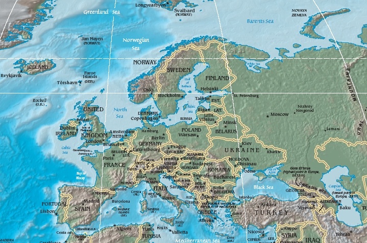
Physical_Map_of_Europe.jpg (719×476 điểm ảnh, kích thước tập tin: 185 kB, kiểu MIME: image/jpeg)
- Extended map (enlarged labels): Image:Europe_terrain_CIA_map_extended.jpg.
Miêu tả
| Miêu tả | Terrain map of Europe, as cropping from the CIA's Physical Map of the World. |
| Ngày | Map dated April 2008 |
| Nguồn gốc | Cropped section from the CIA's Physical Map of the World, formerly available at: but moved to webpage (March 2009): Those webpage URLs require secure-post ("https"), for access, because those pages are encrypted. The larger image this one was cropped from may or may not still be available. |
| Tác giả | work of U.S. CIA |
| Phiên bản khác | Same map in expanded form (more labels):
|
Giấy phép
This image is in the public domain because it contains materials that originally came from the United States Central Intelligence Agency's World Factbook. |  |
Lịch sử tập tin
Nhấn vào ngày/giờ để xem nội dung tập tin tại thời điểm đó.
| Ngày/giờ | Hình xem trước | Kích cỡ | Thành viên | Miêu tả | |
|---|---|---|---|---|---|
| hiện tại | 11:56, ngày 19 tháng 10 năm 2005 | | 719×476 (185 kB) | Grillo | Physical map of Europe. Cropped from http://cia.gov/cia/publications/factbook/reference_maps/pdf/physical_world.pdf and converted to JPG. From en:Image:Physical Map of Europe.jpg {{PD-USGov-CIA-WF}} |
Trang sử dụng tập tin
Có 3 trang tại Wikipedia tiếng Việt có liên kết đến tập tin (không hiển thị trang ở các dự án khác):
Sử dụng tập tin toàn cục
Những wiki sau đang sử dụng tập tin này:
- Trang sử dụng tại as.wikipedia.org
- Trang sử dụng tại bat-smg.wikipedia.org
- Trang sử dụng tại bg.wiktionary.org
- Trang sử dụng tại cy.wikipedia.org
- Trang sử dụng tại da.wikipedia.org
- Sveriges geografi
- Norges geografi
- Danmarks geografi
- Frankrigs geografi
- Irlands geografi
- Liechtensteins geografi
- Tysklands geografi
- Østrigs geografi
- Europas geografi
- Slovakiets geografi
- Monacos geografi
- Tjekkiets geografi
- Sloveniens geografi
- Storbritanniens geografi
- Tyrkiets geografi
- Schweiz' geografi
- Skabelon:Europas geografi
- Hollands geografi
- Ukraines geografi
- Grækenlands geografi
- Trang sử dụng tại de.wikipedia.org
- Trang sử dụng tại el.wikipedia.org
- Trang sử dụng tại en.wikipedia.org
- Trang sử dụng tại es.wikipedia.org
- Trang sử dụng tại es.wikibooks.org
- Trang sử dụng tại fr.wikipedia.org
- Trang sử dụng tại id.wikipedia.org
- Trang sử dụng tại it.wikipedia.org
- Trang sử dụng tại ko.wikiquote.org
- Trang sử dụng tại ky.wikipedia.org
- Trang sử dụng tại lrc.wikipedia.org
- Trang sử dụng tại map-bms.wikipedia.org
- Trang sử dụng tại mk.wikipedia.org
Xem thêm các trang toàn cục sử dụng tập tin này.
Đặc tính hình
🔥 Top keywords: Đài Truyền hình Kỹ thuật số VTCTrang ChínhGiỗ Tổ Hùng VươngTrương Mỹ LanĐặc biệt:Tìm kiếmHùng VươngVương Đình HuệUEFA Champions LeagueKuwaitChiến dịch Điện Biên PhủFacebookĐài Truyền hình Việt NamTrần Cẩm TúĐội tuyển bóng đá quốc gia KuwaitGoogle DịchViệt NamCúp bóng đá U-23 châu ÁCúp bóng đá U-23 châu Á 2024Real Madrid CFBảng xếp hạng bóng đá nam FIFACleopatra VIITô LâmTim CookNguyễn Phú TrọngHồ Chí MinhHai Bà TrưngManchester City F.C.VnExpressChủ tịch nước Cộng hòa xã hội chủ nghĩa Việt NamNguyễn Ngọc ThắngĐền HùngCúp bóng đá trong nhà châu Á 2024Võ Văn ThưởngOne PieceLịch sử Việt NamCuộc đua xe đạp toàn quốc tranh Cúp truyền hình Thành phố Hồ Chí Minh 2024Phạm Minh ChínhTikTokĐinh Tiên Hoàng