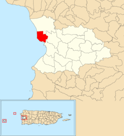
Algarrobos is a barrio in the municipality of Mayagüez, Puerto Rico. Its population in 2010 was 4,383.[3][4][5]
Algarrobos | |
|---|---|
Barrio | |
 Location of Algarrobos within the municipality of Mayagüez shown in red | |
| Coordinates: 18°13′47″N 67°10′02″W / 18.229657°N 67.167322°W[1] | |
| Commonwealth | |
| Municipality | |
| Area | |
| • Total | 2.43 sq mi (6.3 km2) |
| • Land | 1.66 sq mi (4.3 km2) |
| • Water | 0.77 sq mi (2.0 km2) |
| Elevation | 72 ft (22 m) |
| Population (2010) | |
| • Total | 4,383 |
| • Density | 2,640.4/sq mi (1,019.5/km2) |
| Source: 2010 Census | |
| Time zone | UTC−4 (AST) |
Background
Algarrobos is a coastal, rural barrio deriving its name from the Algarrobo tree. The Algarrobo tree is leguminous, with shiny leaves and purple and white flowers. Its fruit is the carob bean, which consists of seeds covered by an edible substance, contained in a capsule-shaped pod.[6]
History
Mayagüez was a perfect smugglers' shelter for being a distance away from the barracks occupied by authorities. Its value was the strategic entrance to the Castillo de los Valdés in Algarrobos. In the eighteenth and nineteenth centuries there was in its jurisdiction a stronghold, the Algarrobo Fort, and Spanish battalions were there, one by the sea and another on the west side of Cerro de El Vigia. In the mid-twentieth century there was an American battalion located by the sea in the vicinity of Peña Cortada.[6]
Algarrobos was in Spain's gazetteers[7] until Puerto Rico was ceded by Spain in the aftermath of the Spanish–American War under the terms of the Treaty of Paris of 1898 and became an unincorporated territory of the United States. In 1899, the United States Department of War conducted a census of Puerto Rico finding that the population of Algarrobo barrio was 1,054.[8]
| Census | Pop. | Note | %± |
|---|---|---|---|
| 1900 | 1,054 | — | |
| 1910 | 1,003 | −4.8% | |
| 1920 | 965 | −3.8% | |
| 1930 | 1,422 | 47.4% | |
| 1940 | 1,796 | 26.3% | |
| 1950 | 1,380 | −23.2% | |
| 1960 | 2,219 | 60.8% | |
| 1970 | 2,769 | 24.8% | |
| 1980 | 5,354 | 93.4% | |
| 1990 | 5,074 | −5.2% | |
| 2000 | 4,792 | −5.6% | |
| 2010 | 4,383 | −8.5% | |
| U.S. Decennial Census 1899 (shown as 1900)[9] 1910-1930[10] 1930-1950[11] 1980-2000[12] 2010[13] | |||
Economy
Between 1962 and 1998 it was the base port and the headquarters of the largest tuna factory in America.[6]

