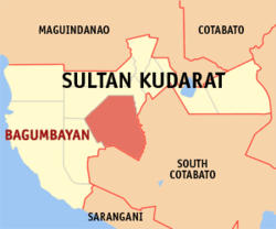
Bagumbayan, officially the Municipality of Bagumbayan (Hiligaynon: Banwa sang Bagumbayan; Maguindanaon: Inged nu Bagumbayan, Jawi: ايڠد نو باڬومباين; Tagalog: Bayan ng Bagumbayan), is a 1st class municipality in the province of Sultan Kudarat, Philippines. According to the 2020 census, it has a population of 68,947 people.[3]
Bagumbayan | |
|---|---|
| Municipality of Bagumbayan | |
 Map of Sultan Kudarat with Bagumbayan highlighted | |
Location within the Philippines | |
| Coordinates: 6°32′02″N 124°33′48″E / 6.533878°N 124.563264°E | |
| Country | Philippines |
| Region | Soccsksargen |
| Province | Sultan Kudarat |
| District | 2nd district |
| Barangays | 19 (see Barangays) |
| Government | |
| • Type | Sangguniang Bayan |
| • Mayor | Jonalette E. De Pedro |
| • Vice Mayor | Ernesto M. Segura Sr. |
| • Representative | Horacio P. Suansing Jr. |
| • Municipal Council | Members |
| • Electorate | 45,153 voters (2022) |
| Area | |
| • Total | 672.06 km2 (259.48 sq mi) |
| Elevation | 178 m (584 ft) |
| Highest elevation | 987 m (3,238 ft) |
| Lowest elevation | 73 m (240 ft) |
| Population (2020 census)[3] | |
| • Total | 68,947 |
| • Density | 100/km2 (270/sq mi) |
| • Households | 16,893 |
| Economy | |
| • Income class | 1st municipal income class |
| • Poverty incidence | 34.50 |
| • Revenue | ₱ 291.3 million (2020) |
| • Assets | ₱ 491.9 million (2020) |
| • Expenditure | ₱ 252 million (2020) |
| • Liabilities | ₱ 155.2 million (2020) |
| Service provider | |
| • Electricity | Sultan Kudarat Electric Cooperative (SUKELCO) |
| Time zone | UTC+8 (PST) |
| ZIP code | 9810 |
| PSGC | |
| IDD : area code | +63 (0)64 |
| Native languages | Hiligaynon Maguindanao Tboli Tagalog |
| Website | www |
History
The municipality of Bagumbayan was transferred from Cotabato Province to Province of Sultan Kudarat on November 22, 1973, by presidential decree 341 by President Ferdinand E. Marcos.[5]
Geography
Barangays
Bagumbayan is politically subdivided into 19 barangays. Each barangay consists of puroks while some have sitios.
- Bai Saripinang
- Biwang
- Busok
- Chua
- Daguma(Mt.Daguma Gunting)
- Daluga
- Kabulanan
- Kanulay
- Kapaya
- Kinayao
- Masiag
- Monteverde
- Poblacion
- Santo Niño
- Sison
- South Sepaka (Shariff Galmak)
- Sumilil
- Titulok
- Tuka
Climate
| Climate data for Bagumbayan, Sultan Kudarat | |||||||||||||
|---|---|---|---|---|---|---|---|---|---|---|---|---|---|
| Month | Jan | Feb | Mar | Apr | May | Jun | Jul | Aug | Sep | Oct | Nov | Dec | Year |
| Mean daily maximum °C (°F) | 31 (88) | 31 (88) | 32 (90) | 32 (90) | 31 (88) | 30 (86) | 29 (84) | 30 (86) | 30 (86) | 30 (86) | 30 (86) | 31 (88) | 31 (87) |
| Mean daily minimum °C (°F) | 23 (73) | 23 (73) | 23 (73) | 24 (75) | 24 (75) | 24 (75) | 24 (75) | 24 (75) | 24 (75) | 24 (75) | 24 (75) | 23 (73) | 24 (74) |
| Average precipitation mm (inches) | 64 (2.5) | 45 (1.8) | 59 (2.3) | 71 (2.8) | 140 (5.5) | 179 (7.0) | 192 (7.6) | 198 (7.8) | 163 (6.4) | 147 (5.8) | 113 (4.4) | 66 (2.6) | 1,437 (56.5) |
| Average rainy days | 12.2 | 10.3 | 12.7 | 15.7 | 26.0 | 27.4 | 28.1 | 28.2 | 26.0 | 26.7 | 22.9 | 16.6 | 252.8 |
| Source: Meteoblue[6] | |||||||||||||
Demographics
| Year | Pop. | ±% p.a. |
|---|---|---|
| 1970 | 26,231 | — |
| 1975 | 19,083 | −6.18% |
| 1980 | 26,855 | +7.07% |
| 1990 | 36,524 | +3.12% |
| 1995 | 45,584 | +4.24% |
| 2000 | 53,444 | +3.47% |
| 2007 | 57,133 | +0.92% |
| 2010 | 63,700 | +4.04% |
| 2015 | 67,061 | +0.98% |
| 2020 | 68,947 | +0.55% |
| Source: Philippine Statistics Authority[7][8][9][10] | ||
Economy
Poverty incidence of Bagumbayan
10 20 30 40 50 2006 41.90 2009 46.92 2012 47.63 2015 40.19 2018 33.10 2021 34.50 Source: Philippine Statistics Authority[11][12][13][14][15][16][17][18] |
Known for its gold and copper deposits, Bagumbayan is Central Mindanao’s new source for export-quality banana and pineapple. Super Green Agricultural Developers Corp. (Sugadco) and SUMIFRU Inc. developed 256 hectares (630 acres) of banana and pineapple plantations in Barangay Kinayao, Bagumbayan town, starting May, 2008. 5 other barangays in the town will later be developed for banana, namely: Bai Saripinang, Daguma, Kapaya, Tuka, Poblacion and Busok.[19]


