Eluru district is a district in coastal Andhra Region in the Indian state of Andhra Pradesh. With Eluru as its administrative headquarters, it was proposed on 26 January 2022 to become one of the resultant twenty six districts in the state once a final notification is issued by the government of Andhra Pradesh. It is formed from Eluru revenue division and Jangareddygudem revenue division from West Godavari district and Nuzvid revenue division from Krishna district.[5][6][7][8]
Eluru district | |
|---|---|
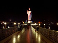
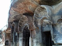
Clockwise from top-left: Buddha Park, Dwaraka Tirumala Temple, Buddhist monuments at Guntupalle, Tangellamudi, Tamileru River near Kolleru | |
 Interactive map outlining district | |
| Country | |
| State | |
| Region | Coastal Andhra |
| Headquarters | Eluru |
| Mandals | 27 |
| Government | |
| • District collector | V Prasanna Venkatesh IAS |
| • Lok Sabha constituencies | Eluru |
| • MP | Kotagiri Sridhar |
| • Assembly constituencies | 07 |
| Area | |
| • Total | 6,579 km2 (2,540 sq mi) |
| Population | |
| • Total | 2,006,737 |
| • Density | 310/km2 (790/sq mi) |
| Demographics | |
| • Sex ratio | 1004 |
| PIN | 534 XXX [3] |
| Vehicle registration | AP-37 (former) AP–39 (from 30 January 2019)[4] |
| Major highways | NH-16, NH-216, NH-216A, NH-365BB, NH-516D, NH-516E |
| Website | eluru |
History
Eluru District history is shared common history with West Godavari district, The Eastern Chalukyas ruled coastal Andhra from 700 to 1200, with Vengi, near Pedavegi village, as their capital. Historical pieces of evidence are found at the villages, Pedavegi and Guntupalli (Jilakarragudem). Eluru then became a part of the Kalinga Empire until 1471. Later it fell into the hands of the Gajapati Empire. In 1515, Krishnadevaraya captured it. After the fall of the Vijayanagara Empire, it was taken by the Sultan of Golconda Fort, Kutub Shah. On 2 April 2022, Eluru District was formed with Eluru as its headquarters and all the district offices and regional offices were set up in Eluru city, Before that it was a Headquarter for West Godavari district.[1]
Geography
The district occupies an area of 6,679 km2 (2,578.776 sq mi). The district is bounded by Khammam district & Alluri Sitharama Raju district on the north, West Godavari district & Konnasemma District on the south. The Godavari River separates East Godavari district on east and Tammileru River and Kolleru Lake separates it from Krishna district and NTR district on the west.[citation needed]
Topography
Rivers and waterbodies
| S.no | Basin | Percentage of Area Covered |
|---|---|---|
| 1 | Godavari River | Yet to be Calculated |
| 2 | Yerrakaluva | Yet to be Calculated |
| 3 | Tammileru | Yet to be Calculated |
| 4 | Ramileru | Yet to be Calculated |
| 5 | Kolleru Lake | Yet to be Calculated |
Climate
The region has a tropical climate similar to the rest of the Coastal Andhra region. The summers (March–June) are hot and dry while the winters are fairly cold. The rainy season (July–December) is often the best time for tourist visits, as fields are brilliantly green with paddy crops, rivers flowing with monsoon water, and a relatively cool climate. The region has long been home to the Indian nobles due to its climate and fertile soil, and several zamindar large mansions are scattered around the Godavari area.[citation needed]
Demographics
At the time of the 2011 census, the mandals which would become Eluru district had a population of 1,937,695, of which 309,424 (15.97%) live in urban areas. Eluru district has a sex ratio of 1002 females per 1000 males and a literacy rate of 71.44%. Scheduled Castes and Scheduled Tribes made up 424,446 (21.90%) and 1,21,311 (6.26%) of the population respectively.[10]: 81–85 [11]: 79–85
At the time of the 2011 census, 93.81% of the population spoke Telugu, 2.68% Koya and 2.60% Urdu as their first language.[12]
Politics
There are one parliamentary and seven assembly constituencies in Eluru district. The parliamentary constituencies are
The assembly constituencies are[13]
| Constituency number | Name | Reserved for | Parliament |
|---|---|---|---|
| 63 | Unguturu | None | Eluru |
| 64 | Denduluru | None | |
| 65 | Eluru | None | |
| 67 | Polavaram | ST | |
| 68 | Chintalapudi | SC | |
| 70 | Nuzvid | None | |
| 73 | Kaikalur | None |
Administrative divisions
The district is divided into 3 revenue divisions: Eluru, Jangareddygudem, and Nuzividu, which are further subdivided into a total of 27 mandals, each headed by a sub-collector.[1]
Mandals
The list of 27 mandals in Eluru district, divided into 3 revenue divisions, is given below.[14]
Cities and towns
| Rank | Division | Municipal pop. | |||||||
|---|---|---|---|---|---|---|---|---|---|
 Eluru  Nuzvidu | 1 | Eluru | Eluru Division | 2,50,834 |  Jangareddygudem | ||||
| 2 | Nuzvidu | Nuzvidu Division | 58,590 | ||||||
| 3 | Jangareddygudem | Jangareddygudem Division | 48,994 | ||||||
| 4 | Chintalapudi | Nuzvidu Division | 25,952 | ||||||
| 5 | Kaikaluru | Eluru Division | 21,292 | ||||||
| 6 | Unguturu | Eluru Division | 14,280 | ||||||
| 7 | Bhimadole | Eluru Division | 13,669 | ||||||
| 8 | Ganapavaram | Eluru Division | 11,749 | ||||||
| 9 | Mudinepalli | Eluru Division | 6463 | ||||||
| 10 | Chatrai | Nuzvidu Division | 4613 | ||||||
| S.No. | Municipal Body | Civic Status of town | No. of wards | Municipality Formation Year | 2011 Census Population |
|---|---|---|---|---|---|
| 1 | Eluru | Municipal Corporation | 50 | 2005 | 2,83,648 |
| 2 | Nuzvid | Municipality Grade – 3 | 32 | 1983 | 1,32,000 |
| 3 | Jangareddygudem | Municipality Grade – 3 | 20 | 2011 | 48,994 |
Culture and tourism

There are many landmarks and tourism destinations in the district. Eluru is the largest city of the district with many destinations related to Buddhists and Archeological importance such as Guntupalli Caves near the city.[15] Eluru city hosts a 74-foot high Buddha statue in the heart of the city.Some of the religious destinations include, Dwaraka Tirumala known with the name as Chinna Tirumala,[16]


Notable people
- Sekhar Kammula, film director
- Kurma Venkata Reddy Naidu, Chief Minister of Madras Presidency
- L. V. Prasad, Indian film producer, actor, director, cinematographer and businessman
- Duvvuri Subbarao, former Reserve Bank Governor
- Silk Smitha, Actress[17]
- Naga Shaurya, Actor[18]
- Baladitya (actor), Actor[19]


