
Size of this preview: 800 × 470 pixels. Other resolutions: 320 × 188 pixels | 640 × 376 pixels | 1,024 × 602 pixels | 1,280 × 753 pixels | 2,304 × 1,355 pixels.
Original file (2,304 × 1,355 pixels, file size: 369 KB, MIME type: image/jpeg)
Summary
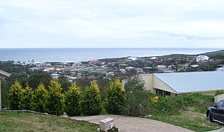
| Description | Boat Harbour, NSW. Although not clear in this image, Stockton Beach can be seen in the background. This image was taken from the highest public point in the suburb at an altitude of 220 ft ASL |
| Date | |
| Source | Own work |
| Author | AussieLegend |
| Camera location | | View this and other nearby images on: OpenStreetMap |
|---|
Licensing
| I, the copyright holder of this work, release this work into the public domain. This applies worldwide. In some countries this may not be legally possible; if so: I grant anyone the right to use this work for any purpose, without any conditions, unless such conditions are required by law. |
File history
Click on a date/time to view the file as it appeared at that time.
| Date/Time | Thumbnail | Dimensions | User | Comment | |
|---|---|---|---|---|---|
| current | 13:33, 1 September 2007 | | 2,304 × 1,355 (369 KB) | AussieLegend | |
| 10:32, 21 August 2007 |  | 2,304 × 1,355 (369 KB) | AussieLegend | {{Information |Description=Boat Harbour, NSW. Although not clear in this image, Stockton Beach can be seen in the background. This image was taken from the highest public point in the suburb at an altitude of 220 ft ASL |Source=self-made |Date=21 August 2 |
File usage
The following pages on the English Wikipedia use this file (pages on other projects are not listed):
Global file usage
The following other wikis use this file:
- Usage on ceb.wikipedia.org
- Usage on fa.wikipedia.org
- Usage on sv.wikipedia.org
- Usage on www.wikidata.org
🔥 Top keywords: Main PageSpecial:SearchIndian Premier LeagueWikipedia:Featured picturesPornhubUEFA Champions League2024 Indian Premier LeagueFallout (American TV series)Jontay PorterXXXTentacionAmar Singh ChamkilaFallout (series)Cloud seedingReal Madrid CFCleopatraRama NavamiRichard GaddDeaths in 2024Civil War (film)Shōgun (2024 miniseries)2024 Indian general electionJennifer PanO. J. SimpsonElla PurnellBaby ReindeerCaitlin ClarkLaverne CoxXXX (film series)Facebook2023–24 UEFA Champions LeagueYouTubeCandidates Tournament 2024InstagramList of European Cup and UEFA Champions League finalsJude BellinghamMichael Porter Jr.Andriy LuninCarlo AncelottiBade Miyan Chote Miyan (2024 film)