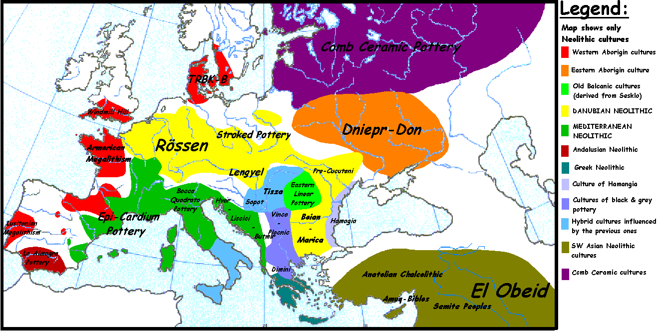
Size of this preview: 800 × 402 pixels. Other resolutions: 320 × 161 pixels | 640 × 321 pixels | 1,320 × 663 pixels.
Original file (1,320 × 663 pixels, file size: 103 KB, MIME type: image/gif)
 | File:European-late-neolithic-english.svg is a vector version of this file. It should be used in place of this GIF file when not inferior. File:European Late Neolithic.gif → File:European-late-neolithic-english.svg For more information, see Help:SVG. |  |
.
Originally uploaded to en-wiki: Quote: "20:54, 5 April 2005 . . Sugaar . . 1320x663 (103135 bytes) (Map of the European Late Neolithic (c. 3500 BCE), showing the main cultures. Made by Sugaar. Free use authorized by the author.)", changed by: "10:05, 28 August 2005 . . Clarifer . . 1320x663 (106193 bytes) (Added the area of the Comb Ceramic cultures. Source: National Board of Antiquities, Finland. www.nba.fi)".
Was uploaded with "PD-self".
_en.png)
.png)
.jpg)
| I, the copyright holder of this work, release this work into the public domain. This applies worldwide. In some countries this may not be legally possible; if so: I grant anyone the right to use this work for any purpose, without any conditions, unless such conditions are required by law. |
File history
Click on a date/time to view the file as it appeared at that time.
| Date/Time | Thumbnail | Dimensions | User | Comment | |
|---|---|---|---|---|---|
| current | 17:43, 20 April 2014 | | 1,320 × 663 (103 KB) | Spiridon Ion Cepleanu | Neolithic shorelines and banks, little details |
| 19:55, 6 February 2006 |  | 1,320 × 663 (104 KB) | Pieter1 | This image was copied from wikipedia:en. The original description was: Map of the European Late Neolithic (c. 3500 BCE), showing the main cultures. {{PD-self}} --Sugaar 22:11, 30 October 2005 (UTC) (I'm not responsible of the modificat | |
| 15:00, 31 December 2005 |  | 1,320 × 663 (104 KB) | Glenn | Originally uploaded to en-wiki: Quote: "20:54, 5 April 2005 . . Sugaar . . 1320x663 (103135 bytes) (Map of the European Late Neolithic (c. 3500 BCE), showing the main cultures. Made by Sugaar. Free use authorized by the author.)", changed by: "10:05, 28 A |
File usage
The following pages on the English Wikipedia use this file (pages on other projects are not listed):
Global file usage
The following other wikis use this file:
- Usage on ast.wikipedia.org
- Usage on az.wikipedia.org
- Usage on ba.wikipedia.org
- Usage on be.wikipedia.org
- Usage on bs.wikipedia.org
- Usage on ca.wikipedia.org
- Usage on cv.wikipedia.org
- Usage on da.wikipedia.org
- Usage on de.wikipedia.org
- Usage on et.wikipedia.org
- Usage on fi.wikipedia.org
- Usage on fr.wikipedia.org
- Usage on fy.wikipedia.org
- Usage on ga.wikipedia.org
- Usage on hu.wikipedia.org
- Usage on it.wikipedia.org
- Usage on ja.wikipedia.org
- Usage on lld.wikipedia.org
- Usage on lt.wikipedia.org
- Usage on pl.wikipedia.org
- Usage on ro.wikipedia.org
- Usage on ru.wikipedia.org
- История Европы
- Каменный век в Европе
- Доисторическая Франция
- Культура воронковидных кубков
- Бутмирская культура
- Культура накольчатой керамики
- Рёссен
- Дунайские культуры
- Доисторическая Белоруссия
- Участник:AlexPin/Археологические культуры Европы
- Доисторический Карпато-Балканский регион
- Участник:Infoman 2016-17 Group 1/sandbox/Draft
- Usage on sk.wikipedia.org
- Usage on sl.wikipedia.org
- Usage on sv.wikipedia.org
View more global usage of this file.
🔥 Top keywords: Main PageSpecial:SearchIndian Premier LeagueWikipedia:Featured picturesPornhubUEFA Champions League2024 Indian Premier LeagueFallout (American TV series)Jontay PorterXXXTentacionAmar Singh ChamkilaFallout (series)Cloud seedingReal Madrid CFCleopatraRama NavamiRichard GaddDeaths in 2024Civil War (film)Shōgun (2024 miniseries)2024 Indian general electionJennifer PanO. J. SimpsonElla PurnellBaby ReindeerCaitlin ClarkLaverne CoxXXX (film series)Facebook2023–24 UEFA Champions LeagueYouTubeCandidates Tournament 2024InstagramList of European Cup and UEFA Champions League finalsJude BellinghamMichael Porter Jr.Andriy LuninCarlo AncelottiBade Miyan Chote Miyan (2024 film)