No higher resolution available.
Physical_Map_of_Europe.jpg (719 × 476 pixels, file size: 185 KB, MIME type: image/jpeg)
- Extended map (enlarged labels): Image:Europe_terrain_CIA_map_extended.jpg.
Summary
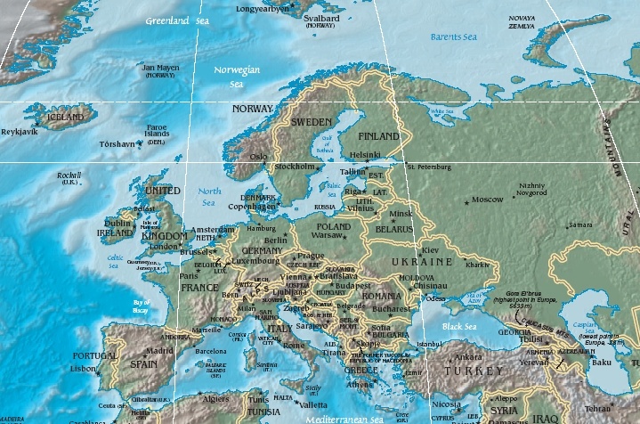
| Description | Terrain map of Europe, as cropping from the CIA's Physical Map of the World. |
| Date | Map dated April 2008 |
| Source | Cropped section from the CIA's Physical Map of the World, formerly available at: but moved to webpage (March 2009): Those webpage URLs require secure-post ("https"), for access, because those pages are encrypted. The larger image this one was cropped from may or may not still be available. |
| Author | work of U.S. CIA |
| Other versions | Same map in expanded form (more labels):
|
Licensing
This image is in the public domain because it contains materials that originally came from the United States Central Intelligence Agency's World Factbook. |  |
File history
Click on a date/time to view the file as it appeared at that time.
| Date/Time | Thumbnail | Dimensions | User | Comment | |
|---|---|---|---|---|---|
| current | 11:56, 19 October 2005 | | 719 × 476 (185 KB) | Grillo | Physical map of Europe. Cropped from http://cia.gov/cia/publications/factbook/reference_maps/pdf/physical_world.pdf and converted to JPG. From en:Image:Physical Map of Europe.jpg {{PD-USGov-CIA-WF}} |
File usage
The following pages on the English Wikipedia use this file (pages on other projects are not listed):
Global file usage
The following other wikis use this file:
- Usage on as.wikipedia.org
- Usage on bat-smg.wikipedia.org
- Usage on bg.wiktionary.org
- Usage on cy.wikipedia.org
- Usage on da.wikipedia.org
- Sveriges geografi
- Norges geografi
- Danmarks geografi
- Frankrigs geografi
- Irlands geografi
- Liechtensteins geografi
- Tysklands geografi
- Østrigs geografi
- Europas geografi
- Slovakiets geografi
- Monacos geografi
- Tjekkiets geografi
- Sloveniens geografi
- Storbritanniens geografi
- Tyrkiets geografi
- Schweiz' geografi
- Skabelon:Europas geografi
- Hollands geografi
- Ukraines geografi
- Grækenlands geografi
- Usage on de.wikipedia.org
- Usage on el.wikipedia.org
- Usage on es.wikipedia.org
- Usage on es.wikibooks.org
- Usage on fr.wikipedia.org
- Usage on id.wikipedia.org
- Usage on it.wikipedia.org
- Usage on ko.wikiquote.org
- Usage on ky.wikipedia.org
- Usage on lrc.wikipedia.org
- Usage on map-bms.wikipedia.org
- Usage on mk.wikipedia.org
- Usage on ml.wikipedia.org
- Usage on nn.wikipedia.org
View more global usage of this file.
Metadata
🔥 Top keywords: Main PageSpecial:SearchIndian Premier LeagueWikipedia:Featured picturesPornhubUEFA Champions League2024 Indian Premier LeagueFallout (American TV series)Jontay PorterXXXTentacionAmar Singh ChamkilaFallout (series)Cloud seedingReal Madrid CFCleopatraRama NavamiRichard GaddDeaths in 2024Civil War (film)Shōgun (2024 miniseries)2024 Indian general electionJennifer PanO. J. SimpsonElla PurnellBaby ReindeerCaitlin ClarkLaverne CoxXXX (film series)Facebook2023–24 UEFA Champions LeagueYouTubeCandidates Tournament 2024InstagramList of European Cup and UEFA Champions League finalsJude BellinghamMichael Porter Jr.Andriy LuninCarlo AncelottiBade Miyan Chote Miyan (2024 film)