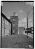
[8] Landmark name Image Date designated[9] Location County Description 1 William Aiken House and Associated Railroad Structures William Aiken House and Associated Railroad Structures November 4, 1963 (#66000698 ) Charleston 32°47′21″N 79°56′15″W / 32.789167°N 79.9375°W / 32.789167; -79.9375 (William Aiken House and Associated Railroad Structures ) Charleston Structures of South Carolina Canal and Railroad Company , the longest operating railroad in the world in 1833, and home of founder William Aiken 2 Atalaya and Brookgreen Gardens Atalaya and Brookgreen Gardens October 5, 1992 (#84002045 ) Murrells Inlet 33°30′50″N 79°05′07″W / 33.513889°N 79.085278°W / 33.513889; -79.085278 (Atalaya and Brookgreen Gardens ) Georgetown Landmark combining Atalaya and portions of Brookgreen Gardens associated with artist Anna Hyatt Huntington 3 Beaufort Historic District Beaufort Historic District November 7, 1973 (#69000159 ) Beaufort 32°26′08″N 80°40′04″W / 32.435556°N 80.667778°W / 32.435556; -80.667778 (Beaufort Historic District ) Beaufort 4 Bethesda Presbyterian Church Bethesda Presbyterian Church February 4, 1985 (#85003258 ) Camden 34°14′48″N 80°36′19″W / 34.246589°N 80.605213°W / 34.246589; -80.605213 (Bethesda Presbyterian Church ) Kershaw Church designed by Robert Mills 5 William Blacklock House William Blacklock House November 7, 1973 (#73001681 ) Charleston 32°46′59″N 79°56′22″W / 32.782927°N 79.939353°W / 32.782927; -79.939353 (William Blacklock House ) Charleston Adamesque house, possibly designed by Gabriel Manigault 6 Borough House Borough House June 7, 1988 (#72001224 ) Stateburg 33°57′14″N 80°32′16″W / 33.953889°N 80.537778°W / 33.953889; -80.537778 (Borough House ) Sumter "The oldest and largest collection of 'high style' pise de terre (rammed earth ) buildings in the United States". Across the road from Church of the Holy Cross 7 Miles Brewton House Miles Brewton House October 9, 1960 (#66000699 ) Charleston 32°46′20″N 79°55′56″W / 32.772131°N 79.932201°W / 32.772131; -79.932201 (Miles Brewton House ) Charleston Fine examples of a "double house" (having four main rooms per floor) in Charleston 8 Robert Brewton House Robert Brewton House October 9, 1960 (#66000700 ) Charleston 32°46′28″N 79°55′45″W / 32.774388°N 79.929041°W / 32.774388; -79.929041 (Robert Brewton House ) Charleston Charleston's oldest dated "single" house (one room wide, with the narrow end toward the street, and entry centered in long side) 9 Brick House Ruins Brick House Ruins April 15, 1970 (#70000580 ) Edisto Island 32°35′59″N 80°19′32″W / 32.599774°N 80.325420°W / 32.599774; -80.325420 (Brick House Ruins ) Charleston Ruins of a plantation house that burned in 1929 10 Burt-Stark Mansion Burt-Stark Mansion October 5, 1992 (#70000559 ) Abbeville 34°10′49″N 82°22′55″W / 34.180317°N 82.382023°W / 34.180317; -82.382023 (Burt-Stark Mansion ) Abbeville Where the American Civil War ended. 11 Camden Battlefield Camden Battlefield January 20, 1961 (#66000707 ) Camden 34°20′47″N 80°36′27″W / 34.346389°N 80.6075°W / 34.346389; -80.6075 (Camden Battlefield ) Kershaw Site of Battle of Camden , British victory in 1780 12 Chapelle Administration Building Chapelle Administration Building December 8, 1976 (#76001710 ) Columbia 34°00′37″N 81°01′15″W / 34.010263°N 81.020966°W / 34.010263; -81.020966 (Chapelle Administration Building ) Richland Allen University building designed by John A. Lankford , "dean of black architecture"13 Charlesfort-Santa Elena Site Charlesfort-Santa Elena Site January 3, 2001 (#74001822 ) Parris Island 32°18′23″N 80°40′32″W / 32.306389°N 80.675556°W / 32.306389; -80.675556 (Charlesfort-Santa Elena Site ) Beaufort Archeological site of French fort built in 1562 and Spanish forts built in 1566 and after.14 Charleston Historic District Charleston Historic District October 9, 1960 (#78002497 ) Charleston 32°47′08″N 79°56′13″W / 32.785556°N 79.936944°W / 32.785556; -79.936944 (Charleston Historic District ) Charleston Historic district including 81 contributing properties and 700 others. 15 Church of the Holy Cross Church of the Holy Cross November 7, 1973 (#73001732 ) Stateburg 33°57′39″N 80°31′55″W / 33.960744°N 80.531944°W / 33.960744; -80.531944 (Church of the Holy Cross ) Sumter Gothic Revival Church constructed of rammed earth in 1852. Across the road from Borough House 16 USS Clamagore USS Clamagore June 29, 1989 (#89001229 ) Mount Pleasant 32°47′16″N 79°54′28″W / 32.787883°N 79.907744°W / 32.787883; -79.907744 (USS Clamagore ) Charleston A submarine that was in training when World War II ended 17 Coker Experimental Farms Coker Experimental Farms July 19, 1964 (#66000706 ) Hartsville 34°21′47″N 80°03′35″W / 34.363056°N 80.059722°W / 34.363056; -80.059722 (Coker Experimental Farms ) Darlington Site of crop-improvement experiments that "played a great role in the agricultural revolution of the South" 18 College of Charleston College of Charleston November 11, 1971 (#71000748 ) Charleston 32°47′03″N 79°56′17″W / 32.784167°N 79.938056°W / 32.784167; -79.938056 (College of Charleston ) Charleston Historic and attractive campus center; Randolph Hall, Towell Library, and Gate Lodge completed by 1856, designed by William Strickland , Edward Brickell White , and George E. Walker 19 Drayton Hall Drayton Hall October 9, 1960 (#66000701 ) Charleston 32°52′15″N 80°04′35″W / 32.8709°N 80.0763°W / 32.8709; -80.0763 (Drayton Hall ) Charleston Plantation house built in 1742 of Palladian architectural style 20 Exchange and Provost Exchange and Provost November 7, 1973 (#69000160 ) Charleston 32°46′37″N 79°55′37″W / 32.776842°N 79.927009°W / 32.776842; -79.927009 (Exchange and Provost ) Charleston Variously a customhouse, mercantile exchange, military prison and barracks, post office, and meeting place of the 1790 State Legislature 21 Farmers' and Exchange Bank Farmers' and Exchange Bank November 7, 1973 (#73001685 ) Charleston 32°46′39″N 79°55′37″W / 32.777435°N 79.926964°W / 32.777435; -79.926964 (Farmers' and Exchange Bank ) Charleston A unique Moorish-style bank building built in 1854 22 Fig Island Upload image March 29, 2007 (#70000585 ) Charleston 32°34′13″N 80°12′55″W / 32.5703°N 80.2153°W / 32.5703; -80.2153 (Fig Island ) Charleston Archaeological site that is "one of the most complex shell-ring sites" in the United States23 Fireproof Building Fireproof Building November 7, 1969 (#69000161 ) Charleston 32°46′37″N 79°55′52″W / 32.776923°N 79.931052°W / 32.776923; -79.931052 (Fireproof Building ) Charleston Designed by Robert Mills to be the most fireproof building in America; now the South Carolina Historical Society building. 24 First Baptist Church First Baptist Church November 7, 1973 (#71000800 ) Columbia 34°00′21″N 81°02′00″W / 34.005864°N 81.033450°W / 34.005864; -81.033450 (First Baptist Church ) Richland Where the American Civil War started, with the secession of South Carolina from the Union. 25 Fort Hill (John C. Calhoun House) Fort Hill (John C. Calhoun House) December 19, 1960 (#66000708 ) Clemson 34°40′34″N 82°50′21″W / 34.675976°N 82.839208°W / 34.675976; -82.839208 (Fort Hill (John C. Calhoun House) ) Pickens Home of John C. Calhoun , now within Clemson University campus. 26 William Gibbes House William Gibbes House April 15, 1970 (#70000575 ) Charleston 32°46′15″N 79°56′04″W / 32.770701°N 79.934493°W / 32.770701; -79.934493 (William Gibbes House ) Charleston Adamesque style home with a beautiful ballroom, and exceptional wrought iron work and marble steps in front27 Graniteville Historic District Graniteville Historic District June 2, 1978 (#78002491 ) Graniteville 33°34′01″N 81°48′30″W / 33.566893°N 81.808377°W / 33.566893; -81.808377 (Graniteville Historic District ) Aiken Textile mill town with Gothic revival church and carpenter gothic homes 28 Hampton Plantation Hampton Plantation April 15, 1970 (#70000582 ) McClellanville 33°11′54″N 79°26′16″W / 33.198333°N 79.437778°W / 33.198333; -79.437778 (Hampton Plantation ) Charleston "South Carolina's finest example of a large two-and-a-half frame Georgian plantation house" 29 Dubose Heyward House Dubose Heyward House November 11, 1971 (#71000749 ) Charleston 32°46′29″N 79°55′45″W / 32.774663°N 79.929029°W / 32.774663; -79.929029 (Dubose Heyward House ) Charleston Home of Dubose Heyward , author of the novel Porgy 30 Heyward-Washington House Heyward-Washington House April 15, 1970 (#70000576 ) Charleston 32°46′31″N 79°55′45″W / 32.775337°N 79.929125°W / 32.775337; -79.929125 (Heyward-Washington House ) Charleston Residence of George Washington during his 1792 visit to Charleston 31 Hibernian Hall Hibernian Hall November 7, 1973 (#73001686 ) Charleston 32°46′39″N 79°55′52″W / 32.777469°N 79.931148°W / 32.777469; -79.931148 (Hibernian Hall ) Charleston 32 Hopsewee Hopsewee November 11, 1971 (#71000782 ) Georgetown 33°12′38″N 79°23′05″W / 33.210556°N 79.384722°W / 33.210556; -79.384722 (Hopsewee ) Georgetown Plantation mansion built in 1749; the birthplace of Thomas Lynch Jr. 33 Huguenot Church Huguenot Church November 7, 1973 (#73001687 ) Charleston 32°46′41″N 79°55′46″W / 32.778090°N 79.929312°W / 32.778090; -79.929312 (Huguenot Church ) Charleston Gothic Revival church built in 1844; designed by architect E. B. White 34 Kahal Kadosh Beth Elohim Kahal Kadosh Beth Elohim June 19, 1980 (#78002499 ) Charleston 32°46′55″N 79°55′59″W / 32.781979°N 79.932948°W / 32.781979; -79.932948 (Kahal Kadosh Beth Elohim ) Charleston Greek revival building from 1840; second oldest synagogue in continuous use in the United States 35 USS Laffey USS Laffey January 14, 1986 (#83002189 ) Mount Pleasant 32°47′16″N 79°54′28″W / 32.787883°N 79.907744°W / 32.787883; -79.907744 (USS Laffey ) Charleston A destroyer 36 Lancaster County Courthouse Lancaster County Courthouse November 7, 1973 (#71000788 ) Lancaster 34°43′17″N 80°46′17″W / 34.721264°N 80.771369°W / 34.721264; -80.771369 (Lancaster County Courthouse ) Lancaster Courthouse in continuous use since 1828; designed by Robert Mills 37 Lancaster County Jail Lancaster County Jail November 7, 1973 (#71000789 ) Lancaster 34°43′06″N 80°46′17″W / 34.718335°N 80.771270°W / 34.718335; -80.771270 (Lancaster County Jail ) Lancaster Former jail building built in 1823, virtually unaltered work of Robert Mills , reflecting innovative changes in jail design he promoted 38 Joseph Manigault House Joseph Manigault House November 7, 1973 (#73001688 ) Charleston 32°47′19″N 79°56′08″W / 32.788703°N 79.935558°W / 32.788703; -79.935558 (Joseph Manigault House ) Charleston Home designed by Gabriel Manigault for his brother 39 Market Hall and Sheds Market Hall and Sheds November 7, 1973 (#73001689 ) Charleston 32°46′51″N 79°55′53″W / 32.780720°N 79.931515°W / 32.780720; -79.931515 (Market Hall and Sheds ) Charleston Greek Revival meat market with two blocks of sheds where vegetables, fish, etc., were sold40 Marshlands Marshlands November 7, 1973 (#73001674 ) Beaufort 32°26′01″N 80°39′57″W / 32.433520°N 80.665831°W / 32.433520; -80.665831 (Marshlands ) Beaufort Home of Dr. James Robert Verdier, who discovered a treatment for yellow fever 41 Middleburg Plantation Middleburg Plantation April 15, 1970 (#70000568 ) Huger 33°04′52″N 79°50′35″W / 33.081111°N 79.843056°W / 33.081111; -79.843056 (Middleburg Plantation ) Berkeley One of the earliest frame plantation houses in the state 42 Middleton Place Middleton Place November 11, 1971 (#71000770 ) Summerville 32°53′59″N 80°08′12″W / 32.899722°N 80.136667°W / 32.899722; -80.136667 (Middleton Place ) Dorchester Plantation mansion and ornamental gardens on the Ashley River 43 Millford Plantation Millford Plantation November 7, 1973 (#71000808 ) Pinewood 33°44′54″N 80°32′15″W / 33.7484°N 80.53745°W / 33.7484; -80.53745 (Millford Plantation ) Sumter A monumental 2-story Greek Revival mansion built in 1839 and meticulously restored in the early 1990s. 44 Mills Building, South Carolina State Hospital Mills Building, South Carolina State Hospital November 7, 1973 (#70000890 ) Columbia 34°00′55″N 81°02′03″W / 34.015160°N 81.034151°W / 34.015160; -81.034151 (Mills Building, South Carolina State Hospital ) Richland Designed by Robert Mills , used from 1827 to 1937; "the oldest building in the country to be used continuously as a mental institution and one of the first mental hospitals built with public funds" 45 Clark Mills Studio Clark Mills Studio December 21, 1965 (#66000703 ) Charleston 32°46′36″N 79°55′46″W / 32.776597°N 79.929503°W / 32.776597; -79.929503 (Clark Mills Studio ) Charleston Studio of self-taught sculptor Clark Mills 46 Robert Mills House Robert Mills House November 7, 1973 (#70000595 ) Columbia 34°00′34″N 81°01′45″W / 34.009444°N 81.029167°W / 34.009444; -81.029167 (Robert Mills House ) Richland Home designed by architect Robert Mills 47 Mulberry Plantation Mulberry Plantation October 9, 1960 (#66000697 ) Moncks Corner 33°08′31″N 80°01′04″W / 33.141944°N 80.017778°W / 33.141944; -80.017778 (Mulberry Plantation ) Berkeley Built in 1714 for a Royal governor; one of the earliest plantation homes in the United States 48 Mulberry Plantation (James and Mary Boykin Chesnut House) Mulberry Plantation (James and Mary Boykin Chesnut House) February 16, 2000 (#80003673 ) Camden 34°12′24″N 80°35′31″W / 34.206528°N 80.591944°W / 34.206528; -80.591944 (Mulberry Plantation (James and Mary Boykin Chesnut House) ) Kershaw Home of Mary Boykin Chesnut and source for her Civil War-time diary describing southern society, "acknowledged as the most important piece of Confederate literature" 49 Ninety-Six and Star Fort Ninety-Six and Star Fort November 7, 1973 (#69000169 ) Ninety Six 34°08′49″N 82°01′28″W / 34.146944°N 82.024444°W / 34.146944; -82.024444 (Ninety-Six and Star Fort ) Greenwood 50 Old Marine Hospital Old Marine Hospital November 7, 1973 (#73001690 ) Charleston 32°46′39″N 79°56′15″W / 32.777621°N 79.937483°W / 32.777621; -79.937483 (Old Marine Hospital ) Charleston Gothic Revival design by Robert Mills built in 1833 to serve sick sailors and other transients51 Parish House of the Circular Congregational Church Parish House of the Circular Congregational Church November 7, 1973 (#73001683 ) Charleston 32°46′45″N 79°55′53″W / 32.779032°N 79.931308°W / 32.779032; -79.931308 (Parish House of the Circular Congregational Church ) Charleston Parish house designed by Robert Mills 52 Penn School Historic District Penn School Historic District December 2, 1974 (#74001824 ) Frogmore 32°23′18″N 80°34′31″W / 32.3883°N 80.5753°W / 32.3883; -80.5753 (Penn School Historic District ) Beaufort School for freed slaves, Gullahs , on St. Helena Island which was occupied by the Union near the outset of the American Civil War 53 Pompion Hill Chapel Pompion Hill Chapel April 15, 1970 (#70000567 ) Huger 33°05′12″N 79°50′12″W / 33.086667°N 79.836667°W / 33.086667; -79.836667 (Pompion Hill Chapel ) Berkeley Episcopal chapel built in 1763, unaltered 54 Powder Magazine Powder Magazine September 27, 1989 (#72001200 ) Charleston 32°46′47″N 79°55′47″W / 32.779656°N 79.929791°W / 32.779656; -79.929791 (Powder Magazine ) Charleston The oldest public building in the city 55 Joseph H. Rainey House Joseph H. Rainey House April 20, 1984 (#84003877 ) Georgetown 33°22′07″N 79°17′02″W / 33.368607°N 79.283817°W / 33.368607; -79.283817 (Joseph H. Rainey House ) Georgetown Home of the first black U.S. Congressman, Joseph H. Rainey , a former slave 56 Robert Barnwell Rhett House Robert Barnwell Rhett House November 7, 1973 (#73001691 ) Charleston 32°47′11″N 79°56′33″W / 32.786250°N 79.942502°W / 32.786250; -79.942502 (Robert Barnwell Rhett House ) Charleston Home of Robert Barnwell Rhett , an extreme secessionist politician, a leading fire-eater at the Nashville Convention of 1850, which failed to endorse his aim of secession 57 Robert William Roper House Robert William Roper House November 7, 1973 (#73001692 ) Charleston 32°46′14″N 79°55′42″W / 32.770529°N 79.928419°W / 32.770529; -79.928419 (Robert William Roper House ) Charleston 58 Nathaniel Russell House Nathaniel Russell House November 7, 1973 (#71000750 ) Charleston 32°46′27″N 79°55′51″W / 32.774177°N 79.930737°W / 32.774177; -79.930737 (Nathaniel Russell House ) Charleston An Adamesque house completed in 1808 59 Edward Rutledge House Edward Rutledge House November 11, 1971 (#71000751 ) Charleston 32°46′34″N 79°56′01″W / 32.776202°N 79.933560°W / 32.776202; -79.933560 (Edward Rutledge House ) Charleston Home of Edward Rutledge , a signer of the Declaration of Independence, and a governor of South Carolina 60 John Rutledge House John Rutledge House November 7, 1973 (#71000752 ) Charleston 32°46′34″N 79°56′01″W / 32.776231°N 79.933563°W / 32.776231; -79.933563 (John Rutledge House ) Charleston Home of Gov. John Rutledge , a signer of the U.S. Constitution. 61 St. James Church, Goose Creek St. James Church, Goose Creek April 15, 1970 (#70000566 ) Goose Creek 32°58′25″N 80°01′47″W / 32.973616°N 80.029594°W / 32.973616; -80.029594 (St. James Church, Goose Creek ) Berkeley Episcopal chapel 62 St. James Church, Santee St. James Church, Santee April 15, 1970 (#70000581 ) Georgetown 33°10′13″N 79°27′56″W / 33.170166°N 79.46569°W / 33.170166; -79.46569 (St. James Church, Santee ) Charleston 63 Saint Michael's Episcopal Church Saint Michael's Episcopal Church October 9, 1960 (#66000704 ) Charleston 32°46′33″N 79°55′51″W / 32.775963°N 79.930931°W / 32.775963; -79.930931 (Saint Michael's Episcopal Church ) Charleston Built in 1750s, Charleston's oldest church building 64 St. Philip's Episcopal Church St. Philip's Episcopal Church November 7, 1973 (#73001695 ) Charleston 32°46′44″N 79°55′46″W / 32.778874°N 79.929469°W / 32.778874; -79.929469 (St. Philip's Episcopal Church ) Charleston Church with E. B. White -designed steeple 65 St. Stephen's Episcopal Church St. Stephen's Episcopal Church April 15, 1970 (#70000570 ) St. Stephen 33°24′19″N 79°55′00″W / 33.4054°N 79.9166°W / 33.4054; -79.9166 (St. Stephen's Episcopal Church ) Berkeley A small Georgian brick country church with a high gambrel roof. 66 Simmons-Edwards House Simmons-Edwards House November 7, 1973 (#71000753 ) Charleston 32°46′22″N 79°56′02″W / 32.7729°N 79.93397°W / 32.7729; -79.93397 (Simmons-Edwards House ) Charleston Known as the "Pineapple Gate House" by locals, referring to finials upon its large brick gates 67 Robert Smalls House Robert Smalls House May 30, 1973 (#74001823 ) Beaufort 32°26′07″N 80°40′05″W / 32.435156°N 80.668186°W / 32.435156; -80.668186 (Robert Smalls House ) Beaufort Post-Civil War home of U.S. congressman Robert Smalls , a former slave who commandeered a Confederate ship out to Union lines 68 Snee Farm Snee Farm November 7, 1973 (#73001702 ) Mount Pleasant 32°50′46″N 79°49′29″W / 32.846111°N 79.824722°W / 32.846111; -79.824722 (Snee Farm ) Charleston Home of early South Carolina Governor Charles Pinckney . 69 Snow's Island Upload image December 2, 1974 (#73001708 ) Across the Peedee River from Dunham Bluff, near Johnsonville [10] 33°50′13″N 79°20′28″W / 33.8369°N 79.3411°W / 33.8369; -79.3411 (Snow's Island ) Florence Revolutionary War era refuge of the "Swamp Fox", Francis Marion 70 South Carolina State House South Carolina State House May 11, 1976 (#70000598 ) Columbia 34°00′02″N 81°01′59″W / 34.000433°N 81.033147°W / 34.000433; -81.033147 (South Carolina State House ) Richland This Greek Revival capitol building was completed in 1907, with major renovations in 1959 and 1998. 71 Stono River Slave Rebellion Site Stono River Slave Rebellion Site May 30, 1974 (#74001840 ) Rantowles 32°47′08″N 80°08′44″W / 32.785501°N 80.145560°W / 32.785501; -80.145560 (Stono River Slave Rebellion Site ) Charleston Beginning point of the earliest slave revolt in the United States. 72 Colonel John Stuart House Colonel John Stuart House November 7, 1973 (#70000578 ) Charleston 32°46′28″N 79°56′02″W / 32.774370°N 79.933807°W / 32.774370; -79.933807 (Colonel John Stuart House ) Charleston Home of Colonel John Stuart . 73 Unitarian Church Unitarian Church November 7, 1973 (#73001696 ) Charleston 32°46′41″N 79°56′04″W / 32.778149°N 79.934554°W / 32.778149; -79.934554 (Unitarian Church ) Charleston Church built in 1772 and reworked in Gothic style during 1852-1854 74 Denmark Vesey House Denmark Vesey House May 11, 1976 (#76001698 ) Charleston 32°46′56″N 79°56′28″W / 32.782209°N 79.941180°W / 32.782209; -79.941180 (Denmark Vesey House ) Charleston Said to be the home of Denmark Vesey , who was accused of plotting slave rebellion in 1822 and executed 75 Woodlands Woodlands November 11, 1971 (#71000742 ) Bamberg 33°17′27″N 80°55′53″W / 33.29085°N 80.931271°W / 33.29085; -80.931271 (Woodlands ) Bamberg The primary residence of author William Gilmore Simms , whose main house was burned in 1865; the remaining wing and several outbuildings constitute a literary landmark. 76 USS Yorktown USS Yorktown January 14, 1986 (#82001519 ) Mount Pleasant 32°47′20″N 79°54′31″W / 32.788792°N 79.908588°W / 32.788792; -79.908588 (USS Yorktown ) Charleston Famous World War II aircraft carrier .jpg)


.jpg)
.jpg)
.jpg)


.jpg)
.jpg)
.jpg)
.jpg)
.jpg)
.jpg)


.jpg)


.jpg)


.jpg)


.jpg)


,_Lancaster,_South_Carolina.jpg)
_Jail.jpg)


.jpg)


.jpg)

.jpg)
.jpg)

.jpg)
.jpg)

.jpg)


.jpg)
.JPG)
.jpg)

.jpg)
.jpg)
.jpg)
.jpg)
.jpg)
.jpg)
.jpg)


.jpg)

.jpg)


.jpg)