The following is an introductory partial list in a series of Recorded Texas Historic Landmarks (RTHLs) arranged by county as designated by the Texas Historical Commission and local county historical commissions in Texas. This initial page includes RTHLs in the following counties: Anderson, Andrews, Angelina, Aransas, Archer, Armstrong, Atascosa, Austin, Bailey, Bandera, Bastrop, Baylor, Bee, Bell, Bexar, Blanco, Borden, Bosque, Bowie, Brazoria, Brazos, Brewster, Briscoe, Brooks, Brown, Burleson, Burnet, Caldwell, Calhoun, and Callahan.
| Anderson-Callahan • Cameron-Duval • Eastland-Gray • Grayson-Hudspeth • Hunt-Martin • Mason-Rusk • Sabine-Travis • Trinity-Zavala |
KEY
Landmarks with multiple historic designations are colored according to their highest designation within the following hierarchy.
| ⁕ Listed individually on the National Register of Historic Places (NRHP) as a National Historic Landmark |
| ⁂ Listed on the NRHP as a contributing property of a National Historic Landmark District |
| † Listed individually on the NRHP |
| ‡ Listed as a contributing property of an NRHP Historic District |
| § Listed individually as or as part of a State Historic Site |
| # Listed individually as or as part of a State Antiquities Landmark |
Anderson County
| Registered Texas Historic Landmark | Image | Marker number | Physical address | Nearest city | Year designated | Description |
|---|---|---|---|---|---|---|
| Anderson County Courthouse† |  | 8732 | 500 N. Church St. | Palestine | 1988 | courthouse square, corner of Lacy and Church |
| Col. G. R. Howard House†‡ |  | 8766 | 1011 N. Perry St. | Palestine | 1966 | 1011 N. Perry St., Palestine |
| First Presbyterian Church† | .jpg) | 8751 | 410 Ave. A | Palestine | 1966 | |
| Frankston Railroad Depot |  | 8756 | 159 W. Railroad St. | Frankston | 1977 | SH 155, Frankston |
| Hodges-Darsey House‡ | .jpg) | 8764 | 517 E. Hodges St. | Palestine | 1973 | 517 E. Hodges St., Palestine |
| I & GN Hospital and Nurses' Quarters‡ |  | 8767 | 919 S. Magnolia St. | Palestine | 1990 | 919 S. Magnolia St., Palestine |
| John Starr House | 8815 | US 287 / SH 19 N of CR 158 | Elkhart | 1968 | State Highway 19 | |
| John and Laura Miller House | 7159 | 3 mi. S on FM 19 | Frankston | 1999 | 3 miles south of Frankston on FM 19 | |
| Link House, The‡ | .jpg) | 8774 | 1003 Link St. | Palestine | 1972 | 1003 Link St., Anderson |
| Mount Vernon African Methodist Episcopal Church† | .jpg) | 8782 | 913 E. Calhoun St. | Palestine | 1986 | 913 E. Calhoun, Palestine |
| Palestine Carnegie Library† |  | 8788 | 502 N. Queen St. | Palestine | 1970 | 502 N. Queen St., Palestine |
| Palestine High School† |  | 8790 | 400 Micheaux Ave. | Palestine | 1986 | 400 Micheaux Ave., Palestine |
| Pennybacker-Campbell-Wommack House‡ | .jpg) | 8796 | 814 S. Sycamore St. | Palestine | 1969 | 814 S. Sycamore at W. Angelina, Palestine |
| Pine Lodge Club House | 8800 | 1.5 mi. S on FM 1817 | Elkhart | 1967 | 1.5 mi. SE of Elkhart on FM 1817 | |
| Sacred Heart Church† | .jpg) | 8806 | 401 W. Oak St. | Palestine | 1964 | 401 W. Oak St. at Queen, Palestine |
| Seven Oaks (Mallard-Alexander House)‡ | 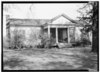 | 7158 | 407 E. Kolstad St. | Palestine | 1966 | |
| The Bowers Mansion‡ | .jpg) | 8739 | 301 S. Magnolia St. | Palestine | 1973 | 301 S. Magnolia St. |
| William and Caroline Broyles House† | .jpg) | 8820 | 1305 S. Sycamore St. | Palestine | 1989 |
Andrews County
| Registered Texas Historic Landmark | Image | Marker number | Physical address | Nearest city | Year designated | Description |
|---|---|---|---|---|---|---|
| "C" Ranch House | 3 | FM 1788 10 mi. N of SH 158 | Andrews | 1966 | From Andrews, 10 mi. from SH 158/FM 1788 intersection; private access | |
| Irwin Ranch House | 2653 | FM 1967 7 mi. W of US 385 | Andrews | 1967 | From Andrews, take U.S. 385 north about 7 miles, then go west on FM 1967 about 7 miles. |
Angelina County
| Registered Texas Historic Landmark | Image | Marker number | Physical address | Nearest city | Year designated | Description |
|---|---|---|---|---|---|---|
| Collins-Shotwell House† |  | 6987 | 503 N. Raguet St. | Lufkin | 1992 | |
| Gibbs House† | 7001 | 156 Grimes-Flournoy Rd. | Huntington vicinity | 1993 | 10 miles south of Huntington on FM 844 | |
| Kurth Home† |  | 8707 | 1860 Old Mill Rd. | Lufkin vicinity | 1964 | on US 69 in Keltys, one mile north of Lufkin |
| Masonic Hall | 18004 | 228 Leach St. | Lufkin | 2014 | ||
| The Gann House |  | 6999 | Off SH 94 near Neches River | Lufkin vicinity | 1970 | near Hwy. 94, 7.5 mi west of Lufkin |
Aransas County
| Registered Texas Historic Landmark | Image | Marker number | Physical address | Nearest city | Year designated | Description |
|---|---|---|---|---|---|---|
| Baldwin-Brundrett House |  | 16918 | 1028 N. Live Oak St. | Rockport | 2011 | 1028 N. Live Oak |
| Bracht House | 16457 | 409 N. Magnolia St. | Rockport | 2010 | ||
| Fulton-Bruhl House | 2084 | 409 Broadway St. | Rockport | 1988 | 409 N. Broadway, Rockport. | |
| Fulton Mansion†§# |  | 2083 | 317 S. Fulton Beach Rd. | Rockport | 1964 | Fulton Mansion State Historic Site. Corner of Henderson and Fulton Beach Road, Fulton |
| Hoopes-Smith House† |  | 2557 | 417 Broadway St. | Rockport | 1989 | 417 N. Broadway, Rockport. |
| Hynes-Balthrope House | 18105 | 801 S. Church St. | Rockport | 2015 | ||
| Joe A. and Bertha Harper House | 17584 | 811 N. Live Oak St. | Rockport | 2013 | ||
| Mathis House† |  | 3256 | 621 S. Church St. | Rockport | 1989 | 621 S. Church Street, Rockport. |
| Moore House | 13692 | 413 S. Church St. | Rockport | 2006 | 413 S. Church Street | |
| Richard Henry Wood House |  | 19965 | 203 N. Magnolia St. | Rockport | 2018 | |
| Rockport School |  | 13653 | 619 N. Live Oak St. | Rockport | 2006 | 619 N Live Oak St |
| Smith-Brundrett House | 18009 | 901 N. Austin St. | Rockport | 2014 | West side of N. Austin Street between Orleans and Cedar Streets at 901 N. Austin, Rockport, Texas, Aransas County | |
| Sorenson-Stair Building | 15535 | 406 S. Austin St. | Rockport | 2008 | 406 S. Austin | |
| Woman's Club of Aransas County |  | 15786 | 1104 E. Concho St. | Rockport | 2009 | |
| Wood-Jackson House | 17218 | 701 N. Magnolia St. | Rockport | 2012 | northeast corner of Magnolia and Nopal |
Archer County
| Registered Texas Historic Landmark | Image | Marker number | Physical address | Nearest city | Year designated | Description |
|---|---|---|---|---|---|---|
| Archer County Courthouse†# |  | 191 | 100 S. Center St. | Archer City | 1963 | Archer County Courthouse, Highway 79, Center Street, Archer City. |
| Archer County Discovery Well | .jpg) | 192 | 100 S. Center St.; marker located at sidewalk leading to W courthouse entrance | Archer City | 1967 | Courthouse lawn, SH 79 and Center Street, Archer City. |
| St. Mary of the Assumption Catholic Church | .jpg) | 18852 | 705 14th St. | Megargel | 2017 | 14th Street at the end of St. Mary's Rd |
Armstrong County
| Registered Texas Historic Landmark | Image | Marker number | Physical address | Nearest city | Year designated | Description |
|---|---|---|---|---|---|---|
| Warner Memorial Community Center | 5720 | 400 Vine St. | Claude | 1962 | 400 Vine Street, Claude. |
Atascosa County
| Registered Texas Historic Landmark | Image | Marker number | Physical address | Nearest city | Year designated | Description |
|---|---|---|---|---|---|---|
| Old Rock Baptist Church | 3795 | Old Rock Road 0.3 mi. S of Roseville Rd. | Somerset | 1971 | Old Rock Road; From Somerset take FM 2790 to Rossville Road. Turn left on Rossville Road, then right onto Old Rock Road. The church and cemetery are located about .25 miles on right. |
Austin County
| Registered Texas Historic Landmark | Image | Marker number | Physical address | Nearest city | Year designated | Description |
|---|---|---|---|---|---|---|
| Austin County Jail† |  | 244 | 36 S. Bell St. | Bellville | 1976 | |
| Bellville Turnverein Pavilion |  | 11703 | 966 E. Main St. | Bellville | 1996 | on East Main Street (FM 529), Bellville |
| E. O. Finn Building | .jpg) | 6349 | 301 E. Main St. | Bellville | 1982 | |
| Hackbarth Building | .jpg) | 17788 | 111 & 113 Main St. | Sealy | 2013 | Sealy, 111-113 Main Street |
| Harigel House, The | .jpg) | 2378 | 104 S. Bell St. | Bellville | 1984 | |
| Haynes-Felcman House | 11701 | 305 Hardeman St. | Sealy | 1999 | at the intersection of Hardeman and Main streets | |
| Hess-Kollatschny Farm House | 2465 | 14992 Cherry Blossom Ln. | Cat Spring | 1982 | Roff Ranch, 2 miles from Cat Spring Agricultural Hall; MARKER REPORTED MISSING 5/2011 | |
| Hill House |  | 11704 | 256 PR 38 | San Felipe | 1962 | On Park Road 38 just off FM 1458, San Felipe. Medallion may be missing. |
| Industry Methodist Church | 14222 | 2131 Pilgrim Rest Ln. | Industry | 1967 | ||
| John Bell Lewis Home | .jpg) | 3079 | 232 S. Masonic St. | Bellville | 1979 | |
| John Reichle General Merchandise (Welcome Store) | 2805 | 12528 FM 109 | Industry | 1992 | from Industry, take FM 109 north about 4 miles | |
| Joseph L. Leshikar House | 1730 | 3373 Skalak Rd. | New Ulm | 1965 | Nelsonville-New Bremen Rd., 4.5 miles south of Nelsonville off SH 159 (private) | |
| L. A. and Adelheid Machemehl House | .jpg) | 3179 | 621 E. O'Bryant St. | Bellville | 1992 | |
| Lambert House | 12402 | 153 Third St. | San Felipe | 1962 | Off FM 1438; MEDALLION REPORTED MISSING 5/2011 | |
| Lindemann-Ott House | 16481 | 2207 Main St. | Industry | 2010 | ||
| Magruder-Cannon-Bryan Home | 3185 | Leschper Rd. | Bellville | 1982 | S. Holland Street, Bellville | |
| Old Roesler Place, The† | 4336 | 12169 SH 159 W | Nelsonville | 1977 | From Nelsonville, take SH 159 west about 2 miles; private. | |
| Paul and Mahala Hackbarth House | .jpg) | 2326 | 325 Sixth St. | Sealy | 1991 | |
| Pitts Place | 11705 | 637 Antonio Martinez St. | San Felipe | 1962 | corner of Park Road 38 and Antonio Martinez St., San Felipe | |
| Preibisch Building | .jpg) | 12526 | 207 Main St. | Sealy | 2001 | corner of Main and Fowlkes streets |
| San Felipe Church | 11706 | 3922 FM 1458 | San Felipe | 1962 | FM 1458 at Park Road 38, San Felipe | |
| San Felipe Town Hall | .jpg) | 4535 | 927 Sixth St. | San Felipe | 1970 | Sixth Street, 0.25 miles east of FM 1458, San Felipe. MARKER REPORTED MISSING 5/2011 |
| Shelburne-Reinecker House | .jpg) | 4666 | 402 S. Masonic St. | Bellville | 1994 | |
| The Wesley Brethren Church† |  | 8405 | 9643 Wesley Church Ln. | Wesley | 1966 | From Brenham, take FM 332 about 10 mi. SW to Wesley Church Rd., follow rd. 1/2 mi. E to church. Wesley is in Washington County but the church is in Austin County. |
| Waddell-Dudensing-Bering Home | 5698 | 5323 Post Oak Point Rd. | New Ulm | 1974 | ||
| Witte-Schmid House† |  | 18687 | 2650 Witte-Schmid Rd. | Shelby | 2017 | near Shelby, TX FM 1457 off of State Highway 159 |
Bailey County
| Registered Texas Historic Landmark | Image | Marker number | Physical address | Nearest city | Year designated | Description |
|---|---|---|---|---|---|---|
| Cookhouse - Muleshoe Ranch |  | 3531 | 2000 W. Ash Ave. | Muleshoe | 1965 | Relocated to Muleshoe Heritage Complex 1986 |
Bandera County
| Registered Texas Historic Landmark | Image | Marker number | Physical address | Nearest city | Year designated | Description |
|---|---|---|---|---|---|---|
| Bandera County Courthouse |  | 291 | 504 Main St. | Bandera | 1972 | 504 Main Street (Highway 16) |
| Bandera County Jail†# |  | 3755 | End of 12th St. SE of Cypress St. | Bandera | 1965 | One block southeast of SH 16, Bandera. |
| Bandera Methodist Church | 292 | 406 11th St. | Bandera | 1967 | Corner of Eleventh and Hackberry Sts., Bandera. | |
| Bandera's First Bank | 294 | 315 11th St. | Bandera | 1965 | Corner of Cedar Street and Eleventh, Bandera. | |
| Benjamin Franklin and Mary Hay Langford, Jr. Home† |  | 12931 | 415 14th St. | Bandera | 2002 | 407 Fourteenth St |
| First Bandera County Courthouse†# |  | 1599 | End of 12th St. SE of Cypress St. | Bandera | 1979 | County agricultural offices, one block southeast of Highway 16, next to old jail, Bandera. |
| Hix Ranch House | 2500 | Windmill Dr. N of FM 3240 | Bandera vicinity | 1965 | From Bandera, take FM 3240 about 8 miles northwest to Ranch entrance, south side of road, just before junction with FM 2828. | |
| Jureczki House† |  | 2890 | 607 Cypress St. | Bandera | 1964 | Northwest corner of Seventh and Cypress, Bandera. |
| Old Buck Ranch | 3694 | Wharton's Dock Rd. at San Julian Creek | Bandera vicinity | 1966 | From Bandera, take FM 689 SE about 1 mile to Wharton's Dock Rd. & follow east about 2 miles to San Julian Creek. (Pass Flying L. Ranch) | |
| Old English-Crist House | 3725 | 3 mi. S of Pipe Creek on FM 1283 | Pipe Creek vicinity | 1968 | From Pipe Creek, take FM 1283 South about 3 mile (house is just before Bottle Creek Rd.) | |
| Old Huffmeyer Store | 3750 | 301 Main St. | Bandera | 1967 | Corner of Main Street and Cypress, Bandera. | |
| Old Stanard Home | 3820 | E edge of town on SH 16 | Medina | 1965 | Hwy. 16, E city limits, Medina | |
| Pilot's Lounge at Bandera Airpark | 18353 | 141 Airport Rd. | Bandera | 2016 | ||
| Polly's Chapel | 2015-2.jpg) | 4067 | 359 Polly's Chapel Rd. | Bandera vicinity | 1965 | From Bandera, take SH 16 about 8 miles northeast to Privilege Creek Bridge. Go north on County Road about 3 miles to Polly's Chapel. |
| Schmidtke-Callahan House | .jpg) | 4601 | 285 SH 16 | Bandera | 1981 | Corner of Cypress (SH 16) and Main, Bandera. |
| Spettel Riverside House | 5008 | Off Spettel Rd. in Bandera County Park | Lakehills | 1981 | Off Park Road 37, Lakehills. Take Ten Thousand Trails Road to recreational area, house is just inside gates - here road changes to Spettel Road. | |
| St. Stanislaus Catholic Church | 5081 | 300 Seventh St. | Bandera | 1962 | ||
| St. Stanislaus Convent and First Catholic School | .jpg) | 5082 | 302 Seventh St. | Bandera | 1975 | Corner of Seventh Street and Cedar Street, Bandera. |
Bastrop County
| Registered Texas Historic Landmark | Image | Marker number | Physical address | Nearest city | Year designated | Description |
|---|---|---|---|---|---|---|
| Aldridge-Fitzwilliam Home | 9146 | 1 mi. S on SH 304 from SH 21 / SH 71 | Bastrop | 1968 | 2 mi. W off highway 204 | |
| Allen-Fowler House† |  | 15623 | 1404 Wilson St. | Bastrop | 2008 | |
| B. D. Orgain House | 2016-2.jpg) | 9215 | 1508 Church St. | Bastrop | 1981 | 1508 Church St., Bastrop |
| Bastrop Christian Church‡ |  | 9150 | 1104 Church St. | Bastrop | 1965 | Corner of Church and Spring Streets |
| Bastrop County Courthouse†# |  | 9153 | 804 Pecan St. | Bastrop | 1964 | Courthouse Square, Pine/Walnut/Pecan/Water streets, Bastrop |
| Bastrop County Jail†# |  | 9154 | 801 Pine St. | Bastrop | 1977 | Corner of Pine and Waters Streets, Bastrop |
| Bastrop Opera House‡ |  | 9158 | 711 Spring St. | Bastrop | 1984 | 711 Spring St., Bastrop |
| Burger Home‡ |  | 9162 | 703 Farm St. | Bastrop | 1979 | 703 Farm St., Bastrop |
| Calvary Episcopal Church‡ |  | 9167 | 605 Spring St. | Bastrop | 1962 | Spring Street, Bastrop |
| Chancellor House‡ |  | 9170 | 201 Ramona St. | Smithville | 1994 | 201 Ramona, Smithville |
| Crocheron-McDowall House† |  | 9174 | 1502 Wilson St. | Bastrop | 1996 | 1502 Wilson, Bastrop |
| D. O. Hill House‡ | 9197 | 502 Olive St. | Smithville | 1962 | 502 Olive St., Smithville | |
| Dr. I. B. Nofsinger House‡ | .jpg) | 9214 | 310 N. Main St. | Elgin | 1982 | 310 N. Main St., Elgin |
| Dr. Sayers' Office‡ | 7162 | 1003 Main St. | Bastrop | 1968 | 1003 Main St., Bastrop | |
| Elgin Methodist Church |  | 9182 | 216 W. Third St. | Elgin | 1988 | 216 W. 3rd St., Elgin |
| First Christian Church (Disciples of Christ) of Smithville‡ |  | 9186 | 400 Burleson St. | Smithville | 1979 | 4th and Burleson, Smithville |
| First Methodist Church of Smithville‡ |  | 9187 | 400 Olive St. | Smithville | 1988 | corner of Olive and 4th St. |
| Governor Sayers House† |  | 9226 | 1703 Wilson St. | Bastrop | 1971 | 1703 Wilson St. |
| H. P. Luckett House† |  | 16996 | 1402 Church St. | Bastrop | 2011 | 1402 Church St., Bastrop |
| Haralson House† |  | 9193 | 1006 Chestnut St. | Bastrop | 1963 | 1006 Chestnut St., Bastrop |
| Hartford Jenkins Home† |  | 9200 | 1302 Pecan St. | Bastrop | 1971 | 1302 Pecan St., Bastrop |
| Henry N. Bell House† |  | 9160 | 1408 Church St. | Bastrop | 1962 | 1408 Church St., Bastrop |
| Hubbard - Trigg House† |  | 9198 | 1508 Pecan St. | Bastrop | 1964 | 1508 Pecan St., Bastrop |
| Jung - Pearcy House† |  | 9203 | 909 Pecan St. | Bastrop | 1964 | 909 Pecan St., Bastrop |
| Kesselus Building‡ | .jpg) | 9204 | 912 Main St. | Bastrop | 1985 | 912 Main St., Bastrop |
| Kleinert Building‡ | .jpg) | 13158 | 910 Main St. | Bastrop | 2003 | Bastrop, 910 Main Street |
| Kleinert - Hoppe House† |  | 9205 | 806 Jefferson St. | Bastrop | 1990 | 806 Jefferson St., Bastrop |
| Leshikar House† |  | 18896 | 301 Mills Street | Smithville | 2018 | 301 Mills St, Smithville |
| Margaret Chambers Home† |  | 9169 | 502 Elm St. | Bastrop | 1962 | 502 Elm St., Bastrop |
| Meeks - Maynard Cabin | 9210 | 8 mi. S on Upper Elgin River Rd. | Elgin | 1965 | 8 mi. south of Elgin on CR 127, upper Elgin River Rd. | |
| Miller - Gillum House | 2016-2.jpg) | 9211 | 100 N. Ave. B | Elgin | 1987 | |
| Mina - Bastrop Pioneers Home† |  | 9212 | 1005 Hill St. | Bastrop | 1964 | 1005 Hill, Bastrop |
| Mt. Olive Baptist Church | 14151 | 250 Mt. Olive Rd. | Bastrop | 2008 | ||
| Murray Burleson Home‡ |  | 9164 | 207 NE Eighth St. | Smithville | 1962 | 207 E. 8th St., Smithville |
| Old Bastrop Academy Bell |  | 9149 | 1201 Main St. | Bastrop | 1966 | 1201 N. Main St., Bastrop |
| Old Cornelson-Fehr House† |  | 9173 | 702 Main St. | Bastrop | 1967 | 702 S. Main St., Bastrop |
| Old Jenkins Home† |  | 9201 | 1710 Main St. | Bastrop | 1964 | 1710 N. Main St., Bastrop |
| P. O. Elzner House† |  | 9183 | 802 Main St. | Bastrop | 1976 | 802 S. Main St., Bastrop |
| Pfeiffer Home† |  | 9218 | 1802 Main St. | Bastrop | 1978 | 1802 Main St., Bastrop |
| R. L. Perkins Home† |  | 9217 | 1307 Church St. | Bastrop | 1965 | 1307 Church St., Bastrop |
| Rabb House‡ |  | 12765 | 401 Colorado St. | Smithville | 2002 | 401 Colorado Street |
| Richard J. and Annie Brieger House† |  | 9161 | 1508 Hill St. | Bastrop | 1994 | 1508 Hill St., Bastrop |
| Rock Front Saloon, 1870 | 2015-2.jpg) | 9222 | 557 Old Hwy. 20 | McDade | 1963 | in McDade, intersection of Loop 323 and US 290 on Main St. - in McDade Historical Museum |
| Scottie Chambliss Jenkins House† |  | 9229 | 801 Pecan St. | Bastrop | 1963 | 801 Pecan St., Bastrop |
| The A. A. Erhard Home† |  | 9184 | 1205 Pecan St. | Bastrop | 1963 | 1205 Pecan St. Marker reported missing May 2009. |
| Trigg Home (Henry E. McGehee House) | 9234 | 5 mi. S on SH 304 | Bastrop | 1964 | 5 mi. S of Bastrop on FM 304 | |
| Wallace - Holme House | 9237 | 907 Pine St. | Bastrop | 1991 | 907 Pine St., Bastrop | |
| White - Turner House† |  | 9238 | 1307 Main St. | Bastrop | 1983 | 1307 Main St., Bastrop |
| Wilbarger House† |  | 7161 | 1403 Main St. | Bastrop | 1967 | 1403 N. Main St., Bastrop |
| Wiley Hill House† |  | 9195 | Hills Prairie Rd. E of SH 304 | Bastrop | 1962 | 5 mi. S of Bastrop on SH 304 county road, cutoff to Hills Prairie |
| Yerge-Hill Family Home‡ | 9241 | 401 Main St. | Smithville | 1965 | 400 Main St., Smithville |
Baylor County
| Registered Texas Historic Landmark | Image | Marker number | Physical address | Nearest city | Year designated | Description |
|---|---|---|---|---|---|---|
| Early Community Building |  | 1 | 200 N. East St. | Seymour | 1969 | S. East and E. Morris streets, Seymour |
| First Christian Church of Seymour |  | 1717 | 401 N. East St. | Seymour | 1970 | 401 N. East St., Seymour |
Bee County
| Registered Texas Historic Landmark | Image | Marker number | Physical address | Nearest city | Year designated | Description |
|---|---|---|---|---|---|---|
| A. C. Jones Home | 7126 | 611 E. Jones St. | Beeville | 1967 | 611 E. Jones St., Beeville | |
| Bee County Courthouse†# |  | 12317 | 105 W. Corpus Christi St. | Beeville | 2000 | |
| Beeville Post Office† |  | 15808 | 111 N. St. Mary's St. | Beeville | 2009 | |
| Camp-Ezell House | 683 | 1313 W. Flournoy St. | Beeville | 1971 | 1313 W. Flournoy, Beeville | |
| Cook Home | 1050 | E edge of town on private road | Beeville | 1966 | W. Cook 1001 St., Beeville | |
| First Christian Church | 1698 | 220 N. Commerce St. | Pettus | 1965 | Corner of Commerce and Walton streets, First Christian Church of Pettus. | |
| George Home | 2155 | 801 N. Adams St. | Beeville | 1966 | 801 N. Adams, Beeville | |
| Jim Little Homestead | 2754 | 0.25 mi. S of FM 799 4 mi. W of town | Beeville | 1966 | W. Cadiz Rd., on private property | |
| McClanahan House | 3840 | 206 E. Corpus Christi St. | Beeville | 1964 | 206 E. Corpus Christi St., Beeville | |
| Medio Creek | 3315 | Marker located 0.2 mi. E of U.S. 59 bridge over Medio Creek | Beeville | 1967 | From Beeville, take US 59 about 4 mi NE to junction of US 59 & Medio Creek, then continue east O.2 mi. | |
| Medio Creek Bridge† |  | 3316 | CR 241 over Medio Creek | Normanna | 1987 | From Normanna, take county road 241 about 1 mile west |
| Park Hotel | 3936 | US 181 N end of town | Tuleta | 1994 | US 181 North, Tuleta (private property) | |
| Praeger Building† |  | 4104 | 110 W. Corpus Christi St. | Beeville | 1981 | 110 W. Corpus Christi St., Beeville (Marker fales Washington St.) |
| Rialto Theater† |  | 13965 | 112-114 N. Washington St. | Beeville | 2007 | |
| Rountree Rock House | 4364 | 6 mi. S on FM 1349 from U.S. 59 | Beeville | 1971 | From Beeville, take US 59 west about 4 mi. Then go south on FM 1349 about 6 mi. | |
| Saint Philip's Episcopal Church | 4487 | 311 E. Corpus Christi St. | Beeville | 1967 | Corner of N. Adams and Corpus Christi Sts., Beeville | |
| Thompson Building (First Brick Building on Square) | 1692 | 108 W. Corpus Christi St. | Beeville | 1971 | 108 W. Corpus Christi, Beeville | |
| William E. Madderra Home | 5824 | 401 N. Adams St. | Beeville | 1983 | 401 N. Adams St. |
Bell County
| Registered Texas Historic Landmark | Image | Marker number | Physical address | Nearest city | Year designated | Description |
|---|---|---|---|---|---|---|
| Anderson Place, Old† | .jpg) | 159 | 35 S. Main St. | Salado | 1965 | |
| Armstrong-Adams House† |  | 205 | 2 N. Main St. | Salado | 1985 | Main and Thomas Arnold Streets, Salado. |
| Avenue D School† |  | 251 | 101 N. College St. | Killeen | 1981 | |
| Bell County Courthouse†‡# |  | 12460 | 101 E. Central Ave. | Belton | 2000 | Central Ave. at Main St. |
| Belton Farmers Co-op Gin† |  | 17122 | 219 S. East St. | Belton | 2012 | One block south east of the Belton Courthouse, backing up to the Nolan Creek |
| Berry-Vickrey House† |  | 380 | 680 N. Main St. | Salado | 1962 | Horsefeathers (2007) |
| Bethel Primitive Baptist Church | 391 | 400 S. Gray St. | Killeen | 1990 | ||
| C. L. Walker Home |  | 6491 | 1206 N. Third St. | Temple | 1978 | |
| Capt. Robert Bonner Halley Home† |  | 2343 | 681 N. Main St. | Salado | 1962 | |
| Carnegie Library Building‡† |  | 733 | 201 N. Main St. | Belton | 1981 | |
| Christ Episcopal Church of Temple‡ |  | 842 | 300 N. Main St. | Temple | 1976 | NW corner of Calhoun & Main |
| Clark House† | 905 | 520 S. Main St. | Belton | 1982 | ||
| Dr. John S. and Mary McCelvey House |  | 11728 | 804 N. 11th St. | Temple | 1999 | |
| Early Bell County Jail |  | 1336 | 210 N. Pearl St. | Belton | 1967 | |
| Ele B. Baggett Home† |  | 1445 | 1019 N. Main St. | Belton | 1983 | |
| Fellrath Building‡ |  | 1586 | 126 N. East St. | Belton | 1984 | corner of East and 1st |
| Ferguson Home† |  | 1591 | 518 N. Seventh St. | Temple | 1967 | MARKER REPORTED MISSING 5/2011 |
| First United Methodist Church of Belton |  | 1882 | 205 N. East St. | Belton | 1978 | N. East St. at 3rd Ave, Belton |
| First United Methodist Church of Temple‡ |  | 1896 | 102 N. Second St. | Temple | 1979 | |
| Fowler House† |  | 2044 | 1301 N. Stagecoach Rd. | Salado | 1968 | US 81, 1 mile north of Salado. |
| George Washington Baines House† |  | 279† | 316 Royal St. | Salado | 1981 | Royal Street, Salado. |
| Grace United Methodist Church |  | 2237 | 601 S. Main St. | Temple | 1983 | |
| Home of Captain A. J. Harris† |  | 2527 | 1001 W. Tenth Ave. | Belton | 1966 | Corner of 10th and Harris Sts., Belton |
| James A. Fletcher House | 1918 | 504 W. Nugent Ave. | Temple | 1981 | ||
| John and Ettie Mayfield House |  | 3268 | 400 W. Travis St. | Holland | 1994 | |
| Luther Memorial† |  | 13713 | Vann Cir., University of Mary Hardin-Baylor | Belton | 2004 | University of Mary Hardin-Baylor campus, Vann Circle Drive |
| M. H. Denman Cabin | .jpg) | 3161 | 601 N. Main St. | Salado | 1968 | Behind Salado Civic Center at corner of Main and Van Bibber Sts., Salado |
| Major A.J. Rose House† |  | 4349 | 101 Rose Way | Salado | 1979 | Corner of William Rose Way at Royal Street, Salado. |
| Maxdale Bridge |  | 3263 | Maxdale Rd. over of Lampasas River S of FM 2670 | Killeen | 1990 | 10 mi. S on SH 195, 3.7 mi. W on FM 2670, 0.3 mi. S on Maxdale Road, south side of bridge. Marker was stolen 2005; recovered and in possession of BCHC |
| Messer-Limmer Farmhouse | 12391 | 1717 Eberhardt Rd. | Temple | 1989 | Texas Early Day Tractor and Engine Association grounds, Eberhardt Rd.; relocated to Temple from Bartlett area ca. 2006; former location=3.8 miles east of Bartlett on FM 487, then 1.6 miles south on Aubrey Messer Rd., then 0.6 miles north on drive to house | |
| MKT of Texas Railway Passenger Depot |  | 23306 | 620 Central Ave. | Temple | 2021 | |
| Muehlhause House |  | 3524 | 620 S. Main St. | Belton | 1994 | Corner of S Main and Ave F |
| Norton-Orgain House† |  | 3614 | 7 N. Main St. | Salado | 1991 | Thomas Arnold and Main Streets, Salado. |
| Omar L. Fletcher Home | 1919 | 1314 N. Ninth St. | Temple | 1979 | ||
| Robertson Home† | .jpg) | 4305 | 646 S. Robertson Rd. | Salado | 1967 | on west side of IH-35, just south of Salado Creek, Salado |
| Salado Methodist Church† |  | 4494 | 650 Royal St. | Salado | 1969 | relocated from corner of Stage Coach & Church Streets in 2005 |
| Sanderford Log Cabin | 4562 | Paddy Hamilton Rd. near FM 93 | Belton | 1967 | Private property near FM 93 and Paddy Hamilton Road | |
| Stagecoach Inn† |  | 5091 | 401 S. Stagecoach Rd. | Salado | 1962 | Main Street (old US 81) at College Hill, Salado. |
| Steakley Home | 5102 | 2207 Marlandwood Rd. | Temple | 1964 | 2207 Marland Wood Road, Temple. | |
| Stinnett's Mill | 5123 | 10195 Stinnett Mill Rd. | Salado vicinity | 1962 | About 4.5 miles NE of Salado on Stinnett's Mill Rd via Rose Rd. | |
| Summers' Mill | 5147 | FM 1123 at Salado Creek | Belton vicinity | 1965 | 5 miles east of Belton on FM 1123 @ Salado Creek; MARKER REPORTED MISSING 5/2011 | |
| Temple Public Library‡ |  | 5223 | 101 N. Main St. | Temple | 1978 | former Temple Post Office building |
| The Curtis Mansion† |  | 1137 | 1004 N. Main St. | Belton | 1977 | NW corner of N. Main & E. Tenth |
| Twelve Oaks† | .jpg) | 5577 | 628 Center Cir. | Salado | 1962 | Center Circle, Salado |
| Wedemeyer House† | .jpg) | 6108 | 404 E. Ninth Ave. | Belton | 1975 | MARKER REPORTED MISSING 5/2011 |
Bexar County
| Registered Texas Historic Landmark | Image | Marker number | Physical address | Nearest city | Year designated | Description |
|---|---|---|---|---|---|---|
| Acequia Madre de Valero (Main Irrigation Ditch of Valero Mission)‡ | .png) | 78 | HemisFair Park, 434 S. Alamo St. | San Antonio | 1968 | Log in Hemis Fair Plaza, S. Alamo St., San Antonio |
| Aldrete Houses‡ | 2016-3.jpg) | 13326 | 526 E. Nueva St. | San Antonio | 1966 | |
| Alexander and Alma Oppenheimer Halff House† |  | 112 | 601 Howard St. | San Antonio | 1997 | 601 Howard Street, San Antonio at West Laurel |
| Alfred Giles Home‡ | 18172 | 308 King William St. | San Antonio | 2015 | ||
| Altgelt-Isbell House‡ |  | 134 | 226 King William St. | San Antonio | 1962 | [house also has Historic American Buildings Survey marker] |
| Anna Barbara and Johann Engelbert Heidgen House† |  | 12947 | 121 Starr St. | San Antonio | 2003 | 121 Starr |
| Anton Wulff House‡ | 2017-3.jpg) | 5914 | 107 King William St. | San Antonio | 1976 | 107 King William St., San Antonio |
| Aqueduct⁕†‡ |  | 177 | Between Espada Rd. and San Antonio River | San Antonio | 1962 | Mission Aqueduct, Espada Rd., San Antonio |
| Arsenal Magazine† |  | 212 | 646 S. Main Ave. | San Antonio | 1977 | |
| Benjamin Grossenbacher House |  | 13360 | 321 N. Alamo St. | San Antonio | 1962 | |
| Biesenbach House‡ | 18355 | 528 King William St. | San Antonio | 2016 | ||
| Boldtville Schoolhouse |  | 447 | 6634 New Sulpher Springs Rd. | San Antonio | 1984 | Loc. at Boltville community, at interection of Sulphur Springs and Foster roads, San Antonio |
| Book Building‡ | 450 | 140 E. Houston St. | San Antonio | 1978 | 140 East Houston, San Antonio; MARKER REPORTED MISSING 5/2011 (may be inside building) | |
| Bullis House |  | 568 | 621 Pierce Ave. | San Antonio | 1983 | |
| Caile House‡ |  | 622 | 526 E. Nueva St. | San Antonio | 1995 | |
| Caile House‡ | .jpg) | 15506 | 526 E. Nueva St. | San Antonio | 1966 | |
| Carl Wilhelm August Groos House‡ |  | 2287 | 335 King William St. | San Antonio | 1977 | 335 King William St., San Antonio |
| Casa Villita‡ |  | 13340 | 511 Villita St. | San Antonio | 1962 | |
| Chabot House‡ | 796 | 403 Madison St. | San Antonio | 1978 | ||
| Christ Episcopal Church‡ | 841 | 301 W. Russell Pl. | San Antonio | 1986 | Russell Pl. at Belknap | |
| Christopher Columbus Italian Society Hall | 848 | 201 Piazza Italia | San Antonio | 1992 | ||
| Cos House‡ |  | 1072 | 503 Villita St. | San Antonio | 1965 | 503 Villita St., San Antonio; MEDALLION REPORTED MISSING 5/2011 |
| David J. and May Bock Woodward House† |  | 13398 | 1717 San Pedro Ave. | San Antonio | 1994 | |
| Dominguez-Micheli Houses | 13344 | 228 Arciniega St. | San Antonio | 1967 | ||
| Dr. Claudius E. R. King House | 2952 | 819 Augusta St. | San Antonio | 1973 | 819 Augusta St., San Antonio | |
| Eagar House# | 1324 | 434 S. Alamo St. | San Antonio | 1962 | 434 S. Alamo, San Antonio | |
| Elias and Lucy Edmonds House‡ |  | 15407 | 419 King William St. | San Antonio | 2008 | |
| Emil Elmendorf House† |  | 1467 | 509 Burleson St. | San Antonio | 1982 | 509 Burleson St., San Antonio; MARKER REPORTED TO BE INSIDE HOUSE 5/2011 |
| Engleman-Muench House†‡ |  | 1483 | 415 E. Sixth St. | San Antonio | 1984 | 415 Sixth St., San Antonio |
| Ernst Homestead | 2016-5(ernst-homestead).jpg) | 1498 | 411 S. Presa St. | San Antonio | 1983 | 411 S. Presa, San Antonio; MARKER REPORTED MISSING 5/2011 |
| Fest-Steves Block†‡ |  | 13349 | 111-121 Military Plaza | San Antonio | 1977 | MARKER REPORTED MISSING 5/2011 |
| Fiesta House‡ |  | 13350 | 231 S. Alamo St. | San Antonio | 1962 | |
| Fort Sam Houston, 4th U.S. Army Headquarters Quadrangle⁂†‡ |  | 2014 | E. Grayson St. at N. New Braunfels Ave. | San Antonio | 1964 | Grayson Street Gate, quadrangle on New Braunfels Rd.; MARKER REPORTED MISSING 5/2011 |
| George Isbell Home‡ |  | 13366 | 226 King William St. | San Antonio | 1962 | |
| German-English School‡ |  | 2178 | 421 S. Alamo St. | San Antonio | 1962 | 421 S.Alamo St., San Antonio |
| Gilbeau Slave Quarters | 13354 | 526 S. Main Ave. | San Antonio | 1965 | ||
| Gould-Onderdonk House‡ | 13355 | 128 W. French Pl. | San Antonio | 1973 | ||
| Gugger Homestead | 14737 | 14464 Old Bandera Rd. | Helotes | 2008 | ||
| Gustav Blersch House‡ | 16997 | 213 Washington St. | San Antonio | 2011 | ||
| Halff House# | .jpg) | 2333 | HemisFair Park, 434 S. Alamo St. | San Antonio | 1966 | Hemisfair Park, S. Alamo St., San Antonio Carcross from La Vallia) |
| Hangar Nine⁕† | .jpg) | 13363 | 8030 Challenger Dr. | San Antonio | 1967 | N of intersection of Challenger Dr. and Inner Circle Rd., Brooks Air Force Base; MARKER REPORTED MISSING 6/2011 |
| J.M. and Birdie Nix House‡ | 2015-2.jpg) | 13658 | 434 King William St. | San Antonio | 2006 | 434 King William |
| Jack Hays House‡ | 13365 | 212 S. Presa St. | San Antonio | 1962 | South Presa at Nueva | |
| Jay Adams House‡ | (jay-adams-house).jpg) | 17233 | 505 Belknap Pl. | San Antonio | 2012 | Northwest corner of Belknap Place and Russell Place |
| Krause House/Mann's Crossing Post Office† |  | 11747 | 8551 Old Pearsall Rd. | San Antonio | 1999 | |
| L. B. Clegg House† |  | 916 | 123 W. Park Ave. | San Antonio | 1978 | |
| La Quinta de las Piedras (Miguel Menchaca House) | 12539 | 19801 Scenic Loop Rd. | Helotes | 1965 | ||
| La Villita† | .jpg) | 3006 | W of S. Alamo St. from E. Chavez Blvd. to Riverwalk | San Antonio | 1962 | Villita Rd., San Antonio |
| Little Church of La Villita‡ |  | 3096 | 508 La Villita St. | San Antonio | 1962 | 508 La Villita. Medallion reported missing Dec. 2005 |
| Locke Hill Auditorium |  | 17996 | 11937 I-10 W | San Antonio | 2014 | East side of IH-10 W. between Huebner Road and DeZavala Road |
| Madison Square Presbyterian Church | 13368 | 319 Camden St. | San Antonio | 1977 | ||
| Majestic Theatre⁕†‡ | .jpg) | 5972 | 212 E. Houston St. | San Antonio | 1991 | 212 E. Houston St., San Antonio |
| Marnoch Homestead | 16488 | 15350 Scenic Loop Rd. | Helotes | 2010 | 15350 Scenic Loop Road | |
| Maverick-Carter House†‡ |  | 16377 | 119 Taylor St. | San Antonio | 2010 | |
| Menger Hotel‡ |  | 3334 | 204 Alamo Plaza | San Antonio | 1965 | Menger Hotel, 204 Alamo Plaza, San Antonio |
| Menger Soap Works† |  | 3336 | 500 N. Santa Rosa St. | San Antonio | 1983 | 500 N. Santa Rosa-backs to Martin St., San Antonio |
| Mission Concepcion⁕†‡# |  | 13372 | 807 Mission Rd. | San Antonio | 1964 | MARKER REPORTED MISSING 5/2011 |
| Mission San Francisco de la Espada Dam, Ditch and Aqueduct⁕†‡ |  | 3412 | Between Espada Rd. and San Antonio River | San Antonio | 1969 | Espada Road |
| Mission San Jose†‡# |  | 3415 | 6701 San Jose Dr. | San Antonio | 1962 | Mission San Jose, Mission Dr. San Antonio; MARKER REPORTED MISSING 6/2011 |
| Mission San Juan Capistrano†‡# | .jpg) | 14071 | 9101 Graf Rd. | San Antonio | 1962 | MARKER REPORTED MISSING 6/2011 |
| Moos Homestead |  | 3466 | 14610 I-10 W | San Antonio | 1964 | northwest corner of IH-10 and Utex Blvd. (Gunn Honda property). Marker reported missing Jan. 2012. |
| Navarro Houses⁕†§# | .jpg) | 3555 | 228 S. Laredo St. | San Antonio | 1962 | 228 S. Laredo St., San Antonio |
| Norton-Polk-Mathis House‡ | 2016-4.jpg) | 3615 | 401 King William St. | San Antonio | 1971 | 401 King William St., San Antonio |
| O. Henry House‡ |  | 2453 | 601 Dolorosa St. | San Antonio | 1964 | corner of Laredo and Dolorosa Sts. |
| Old Edward Steves (Stevens) House‡ |  | 5117 | 509 King William St. | San Antonio | 1970 | 509 King William St., San Antonio |
| Old S. J. Brooks Home‡ | 526 | 155 Croften Ave. | San Antonio | 1969 | (King William District) | |
| Old San Antonio National Bank Building†‡ |  | 3804 | 239 E. Commerce St. | San Antonio | 1979 | 239 East Commerce St. San Antonio |
| Old St. Mary's College‡ | 3819 | 112 College St. | San Antonio | 1969 | located En Route to Riverwalk. 112 College St., San Antonio | |
| Oscar and Rachel Berman House‡ | 13621 | 338 Madison St. | San Antonio | 2006 | ||
| Otto Koehler House |  | 2972 | 310 W. Ashby Pl. | San Antonio | 1975 | 310 W. Ashby Place, San Antonio |
| Pereida House# | 3987 | 510 S. Alamo St. | San Antonio | 1962 | 502 S. Alamo St., San Antonio; MEDALLION REPORTED MISSING 5/2011 | |
| Perrin Home | 13380 | 4101 Swans Landing | San Antonio | 1968 | MARKER REPORTED MISSING 5/2011 | |
| Petty House | 18597 | 10 Tenth St. | San Antonio | 2017 | End of Tenth Street at San Antonio River | |
| R.L. White Ranch† | 17310 | 18744 Bandera Rd. | Helotes | 2012 | on highway approximately in front of Rancho Blanco sign inside fence | |
| Rechel-Stumpf House | 2017-2(@312).jpg) | 4215 | 311 Howard St. | San Antonio | 1962 | 311 Howard St., San Antonio |
| Robert B. Evans Home | 1510 | 7830 E. Evans Rd. | Selma | 1969 | Evans Rd., 4 mi of Fm 1604 (or Anderson Loop), San Antonio | |
| Roy and Madge Hearne House‡ | 18444 | 300 W. French Pl. | San Antonio | 2016 | Southeast corner of West French Place and Belknap Place | |
| Ruiz House‡ |  | 4384 | 3801 Broadway St. | San Antonio | 1966 | Brackenridge Park at the Witte Museum, Broadway, San Antonio |
| Saint Mark's Episcopal Church†‡ |  | 4463 | 315 E. Pecan St. | San Antonio | 1962 | |
| San Antonio Casino Club Building†‡ |  | 752 | 102 W. Crockett St. | San Antonio | 1979 | |
| San Fernando Cathedral†‡ |  | 4538 | 126 E. Main Plaza | San Antonio | 1966 | Main Ave., at main plaza; MARKER REPORTED MISSING 5/2011 |
| San Francisco Di Paola Catholic Church | 4539 | 205 Piazza Italia | San Antonio | 1991 | ||
| Sartor House‡ | 2015-4.jpg) | 4595 | 217 King William St. | San Antonio | 1983 | |
| Schultze Hardware Store | 13388 | 300 S. Alamo St. | San Antonio | 1967 | ||
| Schulze-Schilo House | 4609 | 221 Adams St. | San Antonio | 1986 | ||
| Scottish Rite Cathedral†‡ |  | 4612 | 308 E. Ave. E | San Antonio | 1987 | |
| Site of Old St. Mary's‡ | 3818 | 202 N. St. Mary's St. | San Antonio | 1969 | corner of St.Mary's and College, San Antonio | |
| Site of Original Building, First Baptist Church | 13352 | 407 E. Travis St. | San Antonio | 1967 | SE corner of Travis and Jefferson | |
| Spanish Governor's Palace⁕†‡# |  | 5001 | 105 Military Plaza | San Antonio | 1962 | Military Plaza, San Antonio |
| St. Anthony Catholic School‡ | 14596 | 205 W. Huisache Ave. | San Antonio | 2008 | ||
| St. John's Lutheran Church, "the Rooster Church" | 5045 | 502 E. Nueva St. | San Antonio | 1962 | 502 E. Nueva St., San Antonio; MARKER REPORTED MISSING 5/2011 | |
| St. Joseph's Church‡ | .jpg) | 5049 | 623 E. Commerce St. | San Antonio | 1962 | 623 E. Commerce St., San Antonio |
| St. Mark's Episcopal Church†‡ | 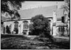 | 5056 | 315 E. Pecan St. | San Antonio | 1992 | |
| St. Paul's Epsicopal Church | 5073 | 1018 E. Grayson St. | San Antonio | 1962 | 1018 E. Grayson, San Antonio | |
| Staacke Brothers Building†‡ |  | 5085 | 309 E. Commerce St. | San Antonio | 1984 | 309 E. Commerce, San Antonio |
| Stevens Building†‡ |  | 5116 | 315 E. Commerce St. | San Antonio | 1984 | 315 E. Commerce, San Antonio |
| Steves Homestead‡ |  | 15493 | 509 King William St. | San Antonio | 1970 | |
| The Alamo⁕†‡# |  | 13324 | 300 Alamo Plaza | San Antonio | 1962 | Alamo Plaza; MARKER REPORTED MISSING 5/2011 |
| The Argyle |  | 197 | 934 Patterson Ave. | Alamo Heights | 1972 | 934 Patterson Ave., Alamo Heights, San Antonio (at doorway) |
| The Bexar County Courthouse†‡# | .jpg) | 399 | 100 Dolorosa St. | San Antonio | 1976 | Main Plaza, San Antonio |
| The Oge House‡ |  | 3680 | 209 Washington St. | San Antonio | 1971 | 209 Washington St., San Antonio |
| Thiele Cottage†‡ |  | 5461 | 411 E. Sixth St. | San Antonio | 1984 | 411 Sixth St., San Antonio |
| Thomas Jefferson High School† |  | 5470 | 723 Donaldson Ave. | San Antonio | 1983 | 723 Donaldson Ave., San Antonio (Marker inside) |
| Toltec Apartments†‡ |  | 17893 | 131 Taylor St. | San Antonio | 2014 | 131 Taylor Street (also known as 110 Auditorium Circle) |
| Twohig House‡ |  | 5585 | 3801 Broadway St. | San Antonio | 1962 | Witte Museum Brackenridge Park, Broadway St., San Antonio |
| Ursuline Convent and Academy†‡ |  | 3828 | 300 Augusta St. | San Antonio | 1962 | Southwest School of Art and Craft, 300 Augusta, San Antonio |
| Vollrath Building |  | 13397 | 712 S. Alamo St. | San Antonio | 1964 | |
| W. B. Teagarden House | 14565 | 408 Dwyer Ave. | San Antonio | 2008 | 408 Dwyer Ave. | |
| William and Mary Ann Richter House‡# | 2016-3(richter-house).jpg) | 13156 | 419 S. Presa St. | San Antonio | 2002 | San Antonio, 419 S Presa; MARKER REPORTED MISSING 5/2011 |
| Wolfson House‡ | 5887 | 415 Broadway St. | San Antonio | 1969 | 415 Broadway, San Antonio | |
| Yturri Homestead and Mill† |  | 5932 | 128 Mission Rd. | San Antonio | 1966 | |
| Zambrano House | 5938 | 104 Anastacia Pl. | San Antonio | 1966 | 104 Anastacia Place, San Antonio (near Breckinridge Park) | |
| Zion Lutheran Church |  | 11752 | 9944 Leslie Rd. | San Antonio | 1997 |
Blanco County
| Registered Texas Historic Landmark | Image | Marker number | Physical address | Nearest city | Year designated | Description |
|---|---|---|---|---|---|---|
| Adrian Edwards Conn Home†‡ |  | 6385 | 503 3rd Street | Blanco | 1966 | corner of Main and 3rd |
| Blanco County Courthouse |  | 427 | 101 E. Pecan Dr. | Johnson City | 1983 | located on courthouse square (7th and G street) in Johnson City |
| Blanco Methodist Church | .jpg) | 431 | 61 Pecan St. | Blanco | 1967 | corner of 1st and Pecan Street in Blanco |
| Goeth Ranch House | 2195 | 0.125 mi. N of RM 962 on CR 304 | Round Mountain | 1972 | from Round Mountain (or US 281) to east on RR 962 then north on CR 304; 1/8 mile down CR 304 | |
| Hye Post Office |  | 2607 | 10261 W. US 290 | Hye | 1966 | US 290 west in Hye, marker is on post office, the only building currently open and operating in the town of Hye. |
| Joseph and Eliza Bird Residence |  | 13484 | 265 Bird Ln. | Round Mountain | 2005 | 265 Bird Lane, off FM 962 |
| L. B. J. Boyhood Home‡ |  | 2828 | 200 E. Elm St. | Johnson City | 1965 | 9th and G Sts. in Johnson City |
| Old Blanco County Courthouse‡# | .jpg) | 428 | 300 Main St. | Blanco | 1972 | Corner of 3rd and Main Street (on public square) in Blanco |
| Saint Mary's Help of Christians Catholic Church |  | 4471 | 1 mi. E of US 281 on CR 473 | Blanco vicinity | 1965 | from Blanco, take US 281 south 6 miles, then go east on CR 473 about one mile; one north side of road |
Borden County
| Registered Texas Historic Landmark | Image | Marker number | Physical address | Nearest city | Year designated | Description |
|---|---|---|---|---|---|---|
| Borden County Jail |  | 457 | Courthouse Square along 100 blk S. Elm St. | Gail | 1967 | Courthouse Square |
Bosque County
| Registered Texas Historic Landmark | Image | Marker number | Physical address | Nearest city | Year designated | Description |
|---|---|---|---|---|---|---|
| Bosque County Courthouse†# | .jpg) | 464 | 110 S. Main St. | Meridian | 1965 | at courthouse square, SH 22, Meridian |
| Clifton College Administration Building |  | 919 | 215 S. College Hill Dr. | Clifton | 1982 | west 9th Street and South Avenue Q |
| Clifton Whipple Truss Bridge | .jpg) | 920 | CR 3265 over North Bosque River | Clifton | 1996 | CR 3265 and FM 1991, northeast part of Clifton |
| First Methodist Church of Valley Mills | .jpg) | 1774 | 501 Ave. C | Valley Mills | 1991 | SH 6 at 5th Street |
| First United Methodist Church of Morgan | .jpg) | 1892 | 907 Charles St. | Morgan | 1983 | Louise and Charles Streets, Morgan |
| Graves-Payne House | .jpg) | 13078 | CR 1140 SE of SH 174 | Morgan | 2004 | 5.3 mi. NE on SH 174, then right on CR 1140 |
| John and Mary Colwick House† | 2825 | Jack Branch Rd. N of CR 4235 | Clifton | 1989 | from Clifton take FM 219 8 miles west; take CR 4230 south 1 mile; take CR 4235 1.1 miles west to house (first on the right) | |
| Odle Log Cabin | 3672 | Odle Ln. near McClennan County line | Valley Mills | 1978 | 5 miles west of Valley Mills via FM 217 to CR 3155 west to Odle Ln. (200 yards north of intersection of Odle Ln and CR 401) | |
| Omenson House† |  | 3859 | At Norway Mill 3 mi. S of FM 219 on FM 182 | Clifton | 1962 | from Clifton take FM 219 west about 7 miles; take FM 182 south about 3 miles; house is located on southeast side of the highway as road turns to the west, through gate reading "Norway Mill" |
| Our Savior's Lutheran Church |  | 3889 | 152 CR 4145 | Clifton | 1965 | from Clifton take FM 219 west about 6.8 miles; take FM 182 2.8 miles north to church |
| Searsville Baptist Church | .jpg) | 4625 | 686 FM 217 | Valley Mills | 1962 | from Valley Mills take FM 217 west about 2 miles to church |
| St. James Episcopal Church | .jpg) | 13712 | 514 N. Bosque St. | Meridian | 2004 | 514 N. Bosque |
| St. Olaf Lutheran Church‡ |  | 18219 | 2680 CR 4145 | Cranfills Gap | 2015 | |
| The Bertelsen House‡ | 5292 | 1 mi. W on CR 4145 from Old St. Olaf Church | Cranfills Gap | 1979 | 2.5 miles northeast of Cranfills Gap via SH 22 north to Old Meridian Creek Road (1 mile before Rock Church) (Private residence) | |
| Valley Mills Santa Fe Railway Depot |  | 5630 | 401 Fifth St. | Valley Mills | 1973 | Valley Mills Park, 5th to 6th Streets on Avenue D, 2 blocks west of SH 6, Valley Mills |
Bowie County
| Registered Texas Historic Landmark | Image | Marker number | Physical address | Nearest city | Year designated | Description |
|---|---|---|---|---|---|---|
| "Ace of Clubs" House† | _(cropped).jpg) | 9493 | 420 Pine St. | Texarkana | 1964 | |
| Black Cherry Tree | 12405 | US 62 on Red River Army Depot | New Boston vicinity | 1969 | 6 miles east of New Boston on US 62 (on U.S. Government reservation) | |
| Central Christian Church |  | 9471 | 903 Walnut St. | Texarkana | 1987 | |
| Cervini House | 9472 | 524 Spruce St. | Texarkana | 1988 | ||
| Dalby Springs Methodist Church | 9474 | CR 4507 at Dalby Rd. | DeKalb | 1965 | 11 miles south of DeKalb on US 259, 1 mi. E on FM 561 | |
| Dr. A. H. A. and Ruby Jones House | 12938 | 1121 S. Lake Dr. | Texarkana | 2002 | 1121 South Lake Dr | |
| Earl-Rochelle House† |  | 11760 | 1920 Magnolia St. | Texarkana | 1997 | |
| Ellis House |  | 11761 | 716 Olive St. | Texarkana | 1997 | |
| Home of Eli H. Moores | 13374 | 1609 New Boston Rd. | Texarkana | 1964 | ||
| Howell W. Runnels Home | 9506 | 1402 W. Ninth St. | Texarkana | 1964 | ||
| Hubbard Home | .jpg) | 9487 | 108 Magnolia St. | New Boston | 1967 | |
| John F. Floyd House | 9481 | 1203 Wood St. | Texarkana | 1989 | ||
| Jones-Tyson House | .jpg) | 9489 | 211 Magnolia St. | New Boston | 1965 | |
| Moores-Burke-Ragland Home | 9494 | 802 Main St. | Texarkana | 1978 | ||
| Offenhauser Building† |  | 9497 | 219 N. State Line Ave. | Texarkana | 1965 | Texarkana Historical Museum; State Line Ave. and Third St. |
| Old Rialto Building† |  | 9503 | 317 N. State Line Ave. | Texarkana | 1966 | |
| Phillip A. Dalby Homestead | 12406 | CR 4315 near county line | DeKalb vicinity | 1966 | 11 miles south of DeKalb on US 259, then 3.3 mi. west on County Line Rd. | |
| Rochelle Place | 9504 | 595 Myrtle Springs Rd. | Texarkana vicinity | 1966 | 9 miles northwest of Texarkana on Myrtle Springs Rd./Birdwell David Dr. | |
| Saenger Theatre†# |  | 9507 | 219 Main St. | Texarkana | 1982 | |
| St. James Episcopal Church | .jpg) | 9509 | 417 Olive St. | Texarkana | 1964 | |
| The Jamison Building | 9488 | 513 W. Third St. | Texarkana | 1983 | 523.5 W. Third St. | |
| United States Post Office and Courthouse† | .jpg) | 9512 | 500 N. State Line Ave. | Texarkana | 1970 | |
| Whitaker House† |  | 9514 | 517 Whitaker St. | Texarkana | 1973 |
Brazoria County
| Registered Texas Historic Landmark | Image | Marker number | Physical address | Nearest city | Year designated | Description |
|---|---|---|---|---|---|---|
| Aldridge-Smith Home | 9518 | 533 Main St. | East Columbia | 1983 | ||
| Allen Place | 9519 | 622 Burnett St. | Quintana | 1964 | Burnett St. near Quintana Beach Park | |
| Bethel Presbyterian Church |  | 9529 | 119 Main St. | East Columbia | 1966 | Duval and Main St. |
| Birchfield - McCown House | 9530 | 404 S. Beauregard St. | Alvin | 1972 | SE corner of Lang and Beauregard St. | |
| Brazoria Bridge† | .jpg) | 9531 | Immediately W of SH 332 bridge over Brazos River | Brazoria vicinity | 1991 | SH 332 and FM 521 interchange, 1 mi. east of Brazoria in roadside park |
| Cummings-Smith House | 9550 | 503 W. Lang St. | Alvin | 1977 | ||
| Freeport National Bank (Freeport Sulphur Company Building) | 9563 | 226 W. Park Ave. | Freeport | 1997 | corner of Board and Park St. | |
| James & Selina Phillips House | 14761 | 104 Main St. | West Columbia | 2008 | ||
| Levi Jordan Plantation§ |  | 9570 | 7234 FM 521 | Brazoria | 1967 | 4 mi. SW of Brazoria on FM 521 just past intersection of FM 521 and FM 524 (Four Corners) |
| Liverpool Cemetery | 9571 | S end of St. Anne St. | Liverpool | 1966 | end of St. Anne St., off CR 171 | |
| M. L. Weems House‡ | 9613 | 716 Main St. | East Columbia | 1962 | Main St., East Columbia | |
| Masonic Oak | 9573 | Pleasant St. across from Masonic Oak Park | Brazoria | 1966 | Pleasant St., across from Masonic Oak Park | |
| Munson Cemetery |  | 9577 | Jimmy Phillips Blvd. W of Munson Ranch Rd. | Bailey's Prairie | 1966 | SH 35 |
| Old Brazoria County Courthouse†# |  | 9533 | 100 Cedar St. | Angleton | 1983 | currently Brazoria Co. Historical Museum, corner of Cedar and SH 288, Angleton |
| Peach Point House | 9580 | SH 36 | Jones Creek | 1964 | on SH 36, Jones Creek | |
| Phair Cemetery | 9586 | Phair Cemetery Rd. | Freeport vicinity | 1966 | in the Phair Community, north of Oyster Creek off FM 523 | |
| Schuster Home | 17999 | 1130 W. Second St. | Freeport | 2014 | ||
| Sweeny Cemetery | 9598 | N. Main St. at edge of town | Sweeny | 1966 | north side of Sweeny, next to flag pole, FM 524 | |
| Sweeny Home | 9599 | 405 E. Locust St. | Angleton | 1986 | ||
| Sweeny-Waddy Log Cabin |  | 9601 | 523 Main St. | East Columbia | 1983 | South Main Street, behind Ammon Underwood House |
| The 1937 Pearland High School | 11765 | 2319 N. Grand Blvd. | Pearland | 1999 | ||
| The Ammon Underwood House† | .jpg) | 9612 | 505 Main St. | East Columbia | 1970 | Main St., East Columbia |
| The Nash-Wright House |  | 9615 | Duval St. at Market St. | East Columbia | 1973 | Duval St., 1 block from SH 35, East Columbia |
| Tyler-Bryan-Weems House‡ | 12937 | 628 Main St. | East Columbia | 2002 | 628 CR 703 | |
| Varner-Hogg Home (The "Varner")†§# | .jpg) | 9603 | 1702 N. 13th St. | West Columbia | 1964 | Varner-Hogg Plantation State Historical Park, north of West Columbia on Park Road |
Brazos County
| Registered Texas Historic Landmark | Image | Marker number | Physical address | Nearest city | Year designated | Description |
|---|---|---|---|---|---|---|
| Astin-Porter Home‡ |  | 8663 | 600 E. 29th St. | Bryan | 1980 | |
| Carnegie Public Library†# |  | 13339 | 111 S. Main St. | Bryan | 1969 | |
| Cavitt House†‡ |  | 8673 | 713 E. 30th St. | Bryan | 1994 | |
| E. J. Jenkins House† |  | 8686 | 607 E. 27th St. | Bryan | 1982 | |
| Edge House† |  | 8676 | 609 S. Ennis St. | Bryan | 1991 | |
| Eugene Edge Home‡ |  | 8677 | 508 E. 30th St. | Bryan | 1985 | |
| LaSalle Hotel† |  | 12883 | 120 S. Main St. | Bryan | 2001 | 120 S. Main St. |
| McMichael-Wilson House‡ |  | 8687 | 712 E. 30th St. | Bryan | 1985 | |
| Queen Theatre |  | 17340 | 110 S. Main St. | Bryan | 2012 | |
| Waldrop House‡ |  | 8700 | 615 E. 29th St. | Bryan | 1983 | |
| Wilkerson House‡ |  | 8702 | 614 E. 29th St. | Bryan | 1983 | |
| Wipprecht Home‡ |  | 16361 | 500 E. 29th St. | Bryan | 2010 |
Brewster County
| Registered Texas Historic Landmark | Image | Marker number | Physical address | Nearest city | Year designated | Description |
|---|---|---|---|---|---|---|
| Albion E. Shepard House | 17696 | 100 NW. Second St. | Marathon | 2013 | NW corner of North Avenue D and North 2nd Street | |
| Brewster County Courthouse†# |  | 1092 | 201 N. Sixth St. | Alpine | 1965 | 5th St., Alpine |
| Chambers Hotel | 801 | 106 SE. First St. | Marathon | 1965 | Main St., Marathon | |
| City Building |  | 872 | 205 E. Sul Ross Ave. | Alpine | 1965 | 205 Ave. E, Alpine |
| First Methodist Church |  | 6405 | 208 E. Sul Ross Ave. | Alpine | 1965 | 208 Ave D., Alpine |
| First School House | 1862 | 106 NE. Third St. | Marathon | 1965 | Off Main Street 1 block west at 4th., Marathon. | |
| Gage-Van Sickle House |  | 2093 | 109 N. Third St. | Alpine | 1965 | 109 W. 3rd St., Alpine |
| Garcia-Valadez House | 2103 | 108 W. Ave F | Alpine | 1968 | 108 W. Ave F, Alpine | |
| Hancock Building |  | 13362 | 118 N. Fifth St. | Alpine | 1965 | |
| Holland Hotel Building |  | 2509 | 207 W. Holland Ave. | Alpine | 1980 | 207 W. Holland, Alpine |
| J.C. Carr-Bob Slight House | 2669 | 406 N. Fifth St. | Alpine | 1968 | 406 5th St., Alpine | |
| Nolte-Rooney House† |  | 3603 | 307 E. Sul Ross Ave. | Alpine | 1968 | 307 Ave. D, Alpine |
| Old Roman Catholic Church | 13386 | 102 W. Gallego Ave. | Alpine | 1965 | ||
| Our Lady of Peace Parish Hall | 3884 | 102 W. Gallego Ave. | Alpine | 1965 | 102 W. Ave G, Alpine | |
| Pioneer School House | 13381 | 106 NE. Third St. | Marathon | 1965 | Off Main St. | |
| Ritchey Hotel, 1886 | 4276 | 102 E. Murphy Ave. | Alpine | 1965 | Corner of Murphy & S. 4th Sts., Alpine; (fronts tracks) | |
| The Gage Hotel |  | 2092 | 102 NW. First St. | Marathon | 1981 | US 90 & Ave. C |
| W. W. Townsend Home | 5679 | 807 W. Ave. D | Alpine | 1986 | 807 W. Ave. D, Alpine |
Briscoe County
| Registered Texas Historic Landmark | Image | Marker number | Physical address | Nearest city | Year designated | Description |
|---|---|---|---|---|---|---|
| Briscoe County Jail | 513 | 400 Broadway St. | Silverton | 1967 | At northeast corner of Courthouse Square, SH 207, Silverton | |
| Pleasant Lafayette Crawford House | 4051 | 200 Pulitzer St. | Silverton | 1983 | 200 Pulitzer, Silverton |
Brooks County
| Registered Texas Historic Landmark | Image | Marker number | Physical address | Nearest city | Year designated | Description |
|---|---|---|---|---|---|---|
| Brooks County Courthouse† |  | 523 | 100 E. Miller St. | Falfurrias | 1977 | US 281, Falfurrias |
Brown County
| Registered Texas Historic Landmark | Image | Marker number | Physical address | Nearest city | Year designated | Description |
|---|---|---|---|---|---|---|
| Adams-Shaw House |  | 83 | 1600 Shaw Dr. | Brownwood | 1975 | |
| Brownwood Harvey House† |  | 11768 | 600 Washington St. | Brownwood | 1999 | adjacent to the Santa Fe Passenger Depot |
| Brownwood Santa Fe Passenger Depot† |  | 12464 | 600 E. Depot St. | Brownwood | 1996 | on Washington Ave., between E. Depot and E. Adams streets |
| Coggin Academy-McClelland Library | .jpg) | 3279 | 1320 Austin Ave. | Brownwood | 1963 | on campus of Howard Payne University |
| J. A. Walker House† |  | 2668 | 701 Center Ave. | Brownwood | 1982 | |
| John Wesley Malone Home | .jpg) | 2821 | 606 Coggin Ave. | Brownwood | 1976 | |
| R. B. Rogers House† |  | 4150 | 707 Center Ave. | Brownwood | 1982 | |
| St. John's Church† |  | 5042 | 700 Main St. | Brownwood | 1962 | Main and Depot Streets, Brownwood. |
| Zephyr Gospel Tabernacle | .jpg) | 5949 | FM 218 at CR 281 | Zephyr | 1976 | SH 218, 1 block east of US 183, Zephyr |
Burleson County
| Registered Texas Historic Landmark | Image | Marker number | Physical address | Nearest city | Year designated | Description |
|---|---|---|---|---|---|---|
| Duewall House | 12724 | 4212 E. SH 21 | Caldwell | 2001 | 4 miles east of Caldwell on SH 21 | |
| Lyons Methodist Church | 8642 | 13608 Pecan Dr. | Lyons | 1968 | Southern Oaks Drive and Pecan Drive (1 block W of SH 36), Lyons | |
| Porter House | 12376 | 5760 CR 324 | Caldwell | 2000 | 4.5 miles west of Caldwell on SH 21, then 5.5 miles north on CR 324 | |
| Reeves-Womack House† | .jpg) | 8650 | 405 W. Fox St. | Caldwell | 1983 | 405 W. Fox St. at Harvey St., Caldwell |
| San Salvador Mission Church |  | 8652 | 9203 CR 286 | Caldwell | 1974 | from Caldwell, take SH 21 E about 11 miles to FM 50, go S about 2 miles to CR 286, go W about 0.5 mile to church |
| Somerville Stadium |  | 18443 | 725 Eighth St. | Somerville | 2016 | Southwest block of 8th Street and Ave. L (middle of block surrounded by 8th Street, Ave. L, 7th Street, Ave. O) |
| Thomas Kraitchar Jr. House† |  | 8639 | 200 E. Buck St. | Caldwell | 1983 | 200 E. Buck St. at Porter St., Caldwell |
| Yegua Center at Somerville ISD |  | 18442 | 616 Eighth St. | Somerville | 2016 | Northeast corner of 8th Street and Ave. L |
Burnet County
| Registered Texas Historic Landmark | Image | Marker number | Physical address | Nearest city | Year designated | Description |
|---|---|---|---|---|---|---|
| 1910 Post Office Building | _02.jpg) | 9740 | 115 Main St. | Marble Falls | 1989 | 115 Main St. |
| Airy Mount Barn | 9695 | 1819 E. Polk St. | Burnet | 1986 | from Burnet take SH 29 E approx. 1 mi. | |
| Brandt Badger House | .jpg) | 9701 | 404 S. Ave. M | Marble Falls | 1974 | 404 S. Avenue M |
| Briggs State Bank† | .jpg) | 13181 | 176 S. Loop 308 | Briggs | 2002 | Briggs, S. Loop 208 |
| Burnet County Jail | 2017-3.jpg) | 9708 | 109 S. Pierce St. | Burnet | 1966 | corner of Washington and Pierce St (NE corner of Courthouse Square) |
| Christian-Matern House | .jpg) | 9706 | 603 Seventh St. | Marble Falls | 1996 | 603 Seventh St. |
| Crownover Chapel | .jpg) | 9709 | 0.2 mi. S on CR 122 from FM 1855 | Marble Falls | 1972 | take US Hwy. 281N approx. 2 mi. to FM 1855; then west on FM 1855 2 miles to Fairland Cemetery (chapel opposite cemetery) |
| Early Oatmeal School | .jpg) | 9738 | 0.5 mi. S of CR 326 on CR 327 | Bertram | 1968 | from Bertram take FM 1174 S approx. .5 mi. to CR 326; west on CR 326 approx. 1.5 mi. to CR 327; south on CR 327 .5 mi. |
| Fort Croghan Stone Building | 9712 | 703 Buchanan Dr. | Burnet | 1966 | on Fort Groghan Museum grounds | |
| George Whitaker Home | .jpg) | 9756 | 802 S. Main St. | Burnet | 1966 | 802 S. Main |
| Governor O. M. Roberts' House | .jpg) | 9743 | 819 Seventh St. | Marble Falls | 1978 | 819 Seventh St. |
| Henry Thomas Lodge, A.F. & A.M. | 9752 | S end of CR 344 | Marble Falls | 1967 | from Marble Falls take FM 1431 E approx. 8 miles to CR 344, then south on CR 344 approx. 2 miles | |
| Hoag-Faubion-Fuchs House |  | 9718 | 902 Ave. F | Marble Falls | 1994 | 902 Avenue F |
| Joppa Iron Truss Bridge | .jpg) | 18764 | E of CR 200 bridge over North Fork San Gabriel River | Bertram | 2017 | In Bertram at traffic light on SH 29, turn east for 0.3 m. on FM 243. Turn left on SH 1174 for 5.5 m. Turn right onto CR 200 for 3.4 miles to Joppa. Located east of new bridge on CR 200. |
| Logan Vandeveer |  | 9755 | 703 Buchanan Dr. | Burnet | 1974 | 703 W. SH 29 (in Fort Croghan Historical Museum complex) |
| Longhorn Cavern Administration Building‡ |  | 9725 | 6211 PR 4 S. | Burnet | 1989 | from Burnet go south on US 281 approx. 5 miles to Park Rd. 4;then west on D4 approx. 7 miles (at park headquarters) |
| Masonic Hall | .jpg) | 13370 | 308 S. Main St. | Burnet | 1966 | 308 S Main St. |
| Old Cook Home | .jpg) | 9707 | 200 N. Main St. | Burnet | 1968 | 200 N. Main |
| Old Thomas Ranch House | 9753 | 1 mi. W of FM 3509 1.5 mi. SW of SH 29 | Burnet | 1968 | from Burnet take SH 29 W approx. 1.5 miles to CR 116; then SW on CR 116 1.5 miles, then west on private ranch road 1 mi. | |
| Oldest Commercial Building in Burnet |  | 9739 | 309 S. Main St. | Burnet | 1966 | 309 S. Main |
| Otto Ebeling House | .jpg) | 9710 | 601 Ave. F | Marble Falls | 1983 | 601 Avenue F |
| Rocky Rest | .jpg) | 9744 | 404 S. Water St. | Burnet | 1966 | 404 S. Water St. |
| Russell Fork Iron Truss Bridge | .jpg) | 18750 | E of CR 272 bridge over Russell Fork San Gabriel River | Bertram | 2017 | In Bertram at traffic light on State Highway 29; east on FM Road 243 for 2.1 miles. Turn left onto CR 272 for 3.9 miles. The bridge is on the east side of the new bridge built in 2005. |
| Stewart Pioneer Home | 9749 | 1 mi. W of Mahomet 500 ft. N of FM 243 | Bertram | 1980 | off FM 243 | |
| Struve House | 9751 | Double Horn Ranch 4 mi. S on CR 401 from SH 71 | Marble Falls | 1973 | private property | |
| The Bryson Place | 9703 | 1100 CR 322 | Bertram | 1982 | on private property | |
| The Galloway House | 9715 | 108 E. League St. | Burnet | 1981 | League and Pierce streets | |
| The Roper Hotel† |  | 9745 | 707 Third St. | Marble Falls | 1981 | 707 Third St. |
| The Russell-McFarland Homestead | 9746 | 309 N. Boundary St. | Burnet | 1978 | 309 N. Boundary St. |
Caldwell County
| Registered Texas Historic Landmark | Image | Marker number | Physical address | Nearest city | Year designated | Description |
|---|---|---|---|---|---|---|
| Caldwell County Courthouse‡# |  | 9760 | 110 S. Main St. | Lockhart | 1976 | Courthouse Square |
| Caldwell County Jail‡ | .jpg) | 9761 | 315 E. Market St. | Lockhart | 1977 | Brazos and Market St. |
| Cardwell Home |  | 9762 | 505 S. Main St. | Lockhart | 1980 | |
| Dr. Eugene Clark Library‡ |  | 9763 | 217 S. Main St. | Lockhart | 1963 | corner of S. Main St. and E. Prairie Lea St. |
| Ebenezer Lutheran Church | 13742 | 291 Church St. | Maxwell | 1986 | 291 Church Street | |
| Emmanuel Episcopal Church†‡ |  | 9768 | 118 N. Church St. | Lockhart | 1962 | corner of N. Church St. and W. Walnut St. |
| First Christian Church (Disciples of Christ) of Lockhart‡ |  | 9770 | 202 W. San Antonio St. | Lockhart | 1985 | corner of W. San Antonio and Church St. |
| Francis-Ainsworth House | 9772 | 214 S. Pecan Ave. | Luling | 1996 | ||
| Karbach-Flowers Home |  | 9779 | 219 Hackberry St. | Lockhart | 1980 | |
| Lockhart Vocational High School (Carver HS)† |  | 14288 | 1104 E. Market St. | Lockhart | 2008 | 1104 E. Market Street |
| Mebane House |  | 9782 | 508 State Park Rd. | Lockhart | 1986 | |
| The Coopwood House |  | 9764 | 412 W. San Antonio St. | Lockhart | 1979 | |
| The Fritz Zedler Home | 9785 | 1115 S. Laurel Ave. | Luling | 1974 | near the corner of S. Laurel St. and SH 80 | |
| William Johnson Cabin | .jpg) | 9778 | 300 blk. N. Magnolia Ave. in Blanche Sq. | Luling | 1973 | corner of US 183 and Austin St. (Blanche Square) |
Calhoun County
| Registered Texas Historic Landmark | Image | Marker number | Physical address | Nearest city | Year designated | Description |
|---|---|---|---|---|---|---|
| Calhoun County Jail# | 627 | 301 S. Ann St. | Port Lavaca | 1983 | 301 S. Ann St., Port Lavaca | |
| Grace Episcopal Church | 1247 | 213 E. Austin St. | Port Lavaca | 1965 | 213 E. Austin Street, Port Lavaca |
Callahan County
| Registered Texas Historic Landmark | Image | Marker number | Physical address | Nearest city | Year designated | Description |
|---|---|---|---|---|---|---|
| Burkett Pecan Tree | 573 | Near end of I-20 N frontage road W of Cooper Creek Rd. (Exit 322) | Putnam | 1966 | 2 mi. E of Putnam on US 80 | |
| Callahan County Courthouse |  | 13799 | 100 W. Fourth St. | Baird | 2003 | 100 W. 4th St. |
| Clyde First Methodist Church | 923 | 217 Oak St. | Clyde | 1986 | ||
| First Callahan Jail |  | 1694 | 100 blk. W. Fifth St. | Baird | 1965 | Courthouse square |
| Merchant Home | 3343 | CR 471 | Baird vicinity | 1962 | from Baird, take US 283 south about 8 miles, then take county road 2.5 miles east for about .75 mile and turn north; follow road north to private property | |
| Prew House | 5406 | 118 Cherry St. | Clyde | 1970 | intersection of Bluebonnet and N. 1st Street, Clyde | |
| Texas & Pacific Railway Depot† |  | 5241 | 100 Market St. | Baird | 1985 | South Market Street & First St., Baird |
See also

| Anderson-Callahan • Cameron-Duval • Eastland-Gray • Grayson-Hudspeth • Hunt-Martin • Mason-Rusk • Sabine-Travis • Trinity-Zavala |
References
External links
![]()
![]() Media related to Recorded Texas Historic Landmarks at Wikimedia Commons
Media related to Recorded Texas Historic Landmarks at Wikimedia Commons
🔥 Top keywords: Main PageSpecial:SearchWikipedia:Featured picturesYasukeHarrison ButkerRobert FicoBridgertonCleopatraDeaths in 2024Joyce VincentXXXTentacionHank AdamsIt Ends with UsYouTubeNew Caledonia2024 Indian general electionHeeramandiDarren DutchyshenSlovakiaKingdom of the Planet of the ApesAttempted assassination of Robert FicoLawrence WongBaby ReindeerXXX: Return of Xander CageThelma HoustonFuriosa: A Mad Max SagaMegalopolis (film)Richard GaddKepler's SupernovaWicked (musical)Sunil ChhetriXXX (2002 film)Ashley MadisonAnya Taylor-JoyPlanet of the ApesNava MauYoung SheldonPortal:Current eventsX-Men '97