Mahatma Gandhi Marine National Park is a national park in India, near Wandoor on the Andaman Islands. It belongs to the South Andaman administrative district, part of the Indian union territory of the Andaman and Nicobar Islands.[4]
| Mahatma Gandhi Marine National Park (M.G.M.N.P) | |
|---|---|
 This is the Mahatma Gandhi Marine National Park near Port Blair, Andaman Islands. Its popularly known as "Jolly buoy" islands. | |
| Location | Andaman Islands, India |
| Nearest city | Wandur |
| Area | 281.5 km2 (108.7 sq mi) |
| Established | 1983 |
Nickname: North Mahatma Gandhi Islands | |
|---|---|
 Labyrinth Islands Location of Labyrinth Islands | |
| Geography | |
| Location | Bay of Bengal |
| Coordinates | 11°32′N 92°36′E / 11.53°N 92.60°E |
| Archipelago | Andaman Islands |
| Adjacent to | Indian Ocean |
| Total islands | 17 |
| Major islands |
|
| Area | 29.043 km2 (11.214 sq mi)land area |
| Highest elevation | 78 m (256 ft)[1] |
| Highest point | Tarmugli Island |
| Administration | |
| District | South Andaman |
| Island group | Andaman Islands |
| Island sub-group | Rutland Archipelago |
| Tehsil | Port Blair Tehsil |
| Largest settlement | Jolly Buoy Beach |
| Demographics | |
| Population | 0 (2011) |
| Additional information | |
| Time zone | |
| PIN | 744103[2] |
| Telephone code | 031927 [3] |
| Official website | www |
| Census Code | 35.639.0004 |
| Official Languages | Hindi, English |
History
The park was created on 24 May 1983 under the Wildlife Protection Act of 1972 protect marine life such as the corals and nesting sea turtles prevalent in the area. It was placed under the protection of the Chief Wildlife Warden of the forest department of the Andaman and Nicobar Islands and it is open creeks running through the park area were a special attraction.[5]
Gallery
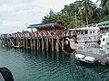 Island dock
 Jolly bouy beach
 Sea of glass in the island
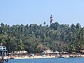 Beachside view
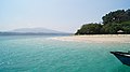 White sand beach in the island


.jpeg)


Geography
There are 2 major island groups in the park: the Labyrinth Islands and the Twin Islands.The islands are situated 16 km (10 mi) south from Port Blair.The marine park covers 281.5 km2 made up of 17 islands and the open sea creeks running through the area. There is a chance for ecotourism on the islands of Jolly Buoy and Red Skin.[6][7][8]The islands belong to the Rutland Archipelago and are located between Rutland Island and South Andaman Island.
Ecosystems of the Island
Most of the coral reefs in the park are fringing reefs. The type and composition of vegetation vary from island to island. Most notably there you can see a difference between the tourist islands which suffer more anthropocentric change and others which do not. There are also some islands more isolated or protected from the effects of weather in the Bay of Bengal. Tarmugli, the largest island, is covered with thick mangrove vegetation, sand covered beaches, uprooted trees and sheet rocks.[9] Twin Islands are an important breeding ground for turtles within the park.
List of Islands
Mahatma Gandhi Marine National Park has some 20 islands and rocks.
Administration
Politically, all islands are part of Port Blair Taluk.[10]
Demographics
The islands are on uninhabited land, but there is a population of 6237 living in 6 adjacent villages (mainly Manglutan and Wandoor)
Image gallery
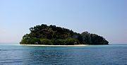 Jolly Buoy Island, one of the 20 islands in the national park.
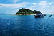 Mahatma Gandhi Marine National Park near Port Blair, Andaman Islands
 Mahatma Gandhi Marine National Park during sunset .


References


 Andaman and Nicobar Islands travel guide from Wikivoyage
- Information about Mahatma Gandhi Marine National Park
- 11 Status of Coral Reefs of Mahatma Gandhi Marine National Park, Wandoor, Andamans by K Dorairaj and R. Soundararajan