| [2] | Name on the Register[3] | Image | Date listed[4] | Location | City or town | Description |
|---|
| 1 | Armory of the Kentish Guards |  Armory of the Kentish Guards Armory of the Kentish Guards | April 28, 1970
(#70000012) | Armory and Peirce Sts.
41°39′40″N 71°27′04″W / 41.661013°N 71.451055°W / 41.661013; -71.451055 (Armory of the Kentish Guards) | East Greenwich | |
|---|
| 2 | Richard Briggs Farm |  Richard Briggs Farm Richard Briggs Farm | June 6, 2003
(#03000517) | 830 South Rd.
41°36′25″N 71°30′38″W / 41.606944°N 71.510556°W / 41.606944; -71.510556 (Richard Briggs Farm) | East Greenwich | |
|---|
| 3 | East Greenwich Historic District | 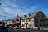 East Greenwich Historic District East Greenwich Historic District | June 13, 1974
(#74000036) | Roughly bounded by Kenyon Ave., Division, Peirce, and London Sts., Greenwich Cove and Dark Entry Brook
41°39′43″N 71°27′17″W / 41.661944°N 71.454722°W / 41.661944; -71.454722 (East Greenwich Historic District) | East Greenwich and Warwick | |
|---|
| 4 | Fry's Hamlet Historic District |  Fry's Hamlet Historic District Fry's Hamlet Historic District | December 20, 1985
(#85003161) | 2068, 2153, 2196, and 2233 S. County Trail
41°38′21″N 71°29′58″W / 41.639167°N 71.499444°W / 41.639167; -71.499444 (Fry's Hamlet Historic District) | East Greenwich | |
|---|
| 5 | Kent County Courthouse | 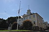 Kent County Courthouse Kent County Courthouse | April 28, 1970
(#70000013) | 127 Main St.
41°39′39″N 71°27′02″W / 41.660833°N 71.450556°W / 41.660833; -71.450556 (Kent County Courthouse) | East Greenwich | Now East Greenwich Town Hall |
|---|
| 6 | Massie Wireless Station | 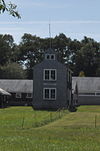 Massie Wireless Station Massie Wireless Station | October 22, 2001
(#01001157) | 1300 Frenchtown Rd. (New England Wireless and Steam Museum)
41°37′33″N 71°30′45″W / 41.625833°N 71.5125°W / 41.625833; -71.5125 (Massie Wireless Station) | East Greenwich | |
|---|
| 7 | Spencer–Shippee–Lillbridge House |  Spencer–Shippee–Lillbridge House Spencer–Shippee–Lillbridge House | April 20, 2011
(#11000207) | 12 Middle Rd.
41°39′16″N 71°27′51″W / 41.654444°N 71.464167°W / 41.654444; -71.464167 (Spencer–Shippee–Lillbridge House) | East Greenwich | |
|---|
| 8 | Tillinghast Mill Site |  Tillinghast Mill Site Tillinghast Mill Site | March 10, 1988
(#88000164) | Frenchtown Park
41°37′41″N 71°30′23″W / 41.62805°N 71.506326°W / 41.62805; -71.506326 (Tillinghast Mill Site) | East Greenwich | |
|---|
| 9 | Tillinghast Road Historic District |  Tillinghast Road Historic District Tillinghast Road Historic District | March 9, 1988
(#88000167) | Tillinghast Rd.
41°37′03″N 71°30′39″W / 41.6175°N 71.510833°W / 41.6175; -71.510833 (Tillinghast Road Historic District) | East Greenwich | |
|---|
| 10 | Gen. James Mitchell Varnum House |  Gen. James Mitchell Varnum House Gen. James Mitchell Varnum House | August 12, 1971
(#71000016) | 57 Peirce St.
41°39′49″N 71°27′06″W / 41.663611°N 71.451667°W / 41.663611; -71.451667 (Gen. James Mitchell Varnum House) | East Greenwich | |
|---|
| 11 | Clement Weaver-Daniel Howland House |  Clement Weaver-Daniel Howland House Clement Weaver-Daniel Howland House | November 7, 1995
(#95001266) | 125 Howland Rd.
41°39′32″N 71°28′40″W / 41.658889°N 71.477778°W / 41.658889; -71.477778 (Clement Weaver-Daniel Howland House) | East Greenwich | |
|---|
| 12 | Col. Micah Whitmarsh House | 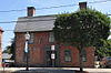 Col. Micah Whitmarsh House Col. Micah Whitmarsh House | February 18, 1971
(#71000017) | 294 Main St.
41°39′34″N 71°27′01″W / 41.659444°N 71.450278°W / 41.659444; -71.450278 (Col. Micah Whitmarsh House) | East Greenwich | |
|---|
| 13 | Windmill Cottage |  Windmill Cottage Windmill Cottage | May 22, 1973
(#73000051) | 144 Division St.
41°39′49″N 71°27′23″W / 41.663611°N 71.456389°W / 41.663611; -71.456389 (Windmill Cottage) | East Greenwich | |
|---|


