| [2] | Name on the Register[3] | Image | Date listed[4] | Location | City or town | Description |
|---|
| 1 | Albree-Hall-Lawrence House | 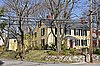 Albree-Hall-Lawrence House Albree-Hall-Lawrence House | April 30, 1976
(#76000256) | 353 Lawrence Rd.
42°25′29″N 71°07′12″W / 42.424722°N 71.12°W / 42.424722; -71.12 (Albree-Hall-Lawrence House) | | |
|---|
| 2 | John B. Angier House | 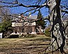 John B. Angier House John B. Angier House | April 23, 1975
(#75000267) | 129 High St.
42°25′12″N 71°06′54″W / 42.42°N 71.115°W / 42.42; -71.115 (John B. Angier House) | | |
|---|
| 3 | Bigelow Block |  Bigelow Block Bigelow Block | February 24, 1975
(#75000268) | NE Corner of Forest and Salem Sts.
42°25′06″N 71°06′36″W / 42.418333°N 71.11°W / 42.418333; -71.11 (Bigelow Block) | | |
|---|
| 4 | Charles Brooks House |  Charles Brooks House Charles Brooks House | June 18, 1975
(#75000269) | 309 High St.
42°25′18″N 71°07′28″W / 42.421667°N 71.124444°W / 42.421667; -71.124444 (Charles Brooks House) | | |
|---|
| 5 | Jonathan Brooks House | 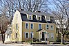 Jonathan Brooks House Jonathan Brooks House | June 26, 1975
(#75000270) | 2 Woburn St.
42°25′18″N 71°07′26″W / 42.421667°N 71.123889°W / 42.421667; -71.123889 (Jonathan Brooks House) | | |
|---|
| 6 | Shepherd Brooks Estate |  Shepherd Brooks Estate Shepherd Brooks Estate | April 21, 1975
(#75000271) | 275 Grove St.
42°26′00″N 71°08′22″W / 42.433333°N 71.139444°W / 42.433333; -71.139444 (Shepherd Brooks Estate) | | |
|---|
| 7 | Paul Curtis House |  Paul Curtis House Paul Curtis House | May 6, 1975
(#75000272) | 114 South St.
42°25′02″N 71°07′01″W / 42.417222°N 71.116944°W / 42.417222; -71.116944 (Paul Curtis House) | | |
|---|
| 8 | Fells Connector Parkways, Metropolitan System of Greater Boston |  Fells Connector Parkways, Metropolitan System of Greater Boston Fells Connector Parkways, Metropolitan System of Greater Boston | May 9, 2003
(#03000379) | Fellsway East:E. Border Rd. To Fellsway W
Fellsway West: Fulton St. to Fellsway E
Fellsway:Fellsway E to Wellington Br
42°26′40″N 71°04′45″W / 42.444444°N 71.079167°W / 42.444444; -71.079167 (Fells Connector Parkways, Metropolitan System of Greater Boston) | | Extends into Malden. |
|---|
| 9 | George P. Fernald House |  George P. Fernald House George P. Fernald House | April 30, 1976
(#76000258) | 12 Rock Hill St.
42°25′14″N 71°07′23″W / 42.420556°N 71.123056°W / 42.420556; -71.123056 (George P. Fernald House) | | |
|---|
| 10 | Jonathan Fletcher House | 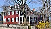 Jonathan Fletcher House Jonathan Fletcher House | June 23, 1975
(#75000274) | 283 High St.
42°25′18″N 71°07′23″W / 42.421667°N 71.123056°W / 42.421667; -71.123056 (Jonathan Fletcher House) | | |
|---|
| 11 | Grace Episcopal Church |  Grace Episcopal Church Grace Episcopal Church | November 3, 1972
(#72000139) | 160 High St.
42°25′12″N 71°07′00″W / 42.42°N 71.116667°W / 42.42; -71.116667 (Grace Episcopal Church) | | |
|---|
| 12 | Isaac Hall House |  Isaac Hall House Isaac Hall House | April 16, 1975
(#75000275) | 43 High St.
42°25′07″N 71°06′41″W / 42.418611°N 71.111389°W / 42.418611; -71.111389 (Isaac Hall House) | | |
|---|
| 13 | Hillside Avenue Historic District |  Hillside Avenue Historic District Hillside Avenue Historic District | April 21, 1975
(#75000276) | Property on both sides of Hillside and Grand View Aves.
42°25′13″N 71°06′46″W / 42.420278°N 71.112778°W / 42.420278; -71.112778 (Hillside Avenue Historic District) | | |
|---|
| 14 | Lawrence Light Guard Armory | 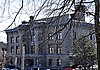 Lawrence Light Guard Armory Lawrence Light Guard Armory | March 10, 1975
(#75000277) | 90 High St.
42°25′07″N 71°06′47″W / 42.418611°N 71.113056°W / 42.418611; -71.113056 (Lawrence Light Guard Armory) | | |
|---|
| 15 | Joseph K. Manning House | 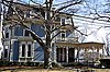 Joseph K. Manning House Joseph K. Manning House | April 7, 1989
(#88000712) | 35–37 Forest St.
42°25′11″N 71°06′37″W / 42.419722°N 71.110278°W / 42.419722; -71.110278 (Joseph K. Manning House) | | |
|---|
| 16 | John H. McGill House |  John H. McGill House John H. McGill House | April 9, 1980
(#80000640) | 56 Vernon St.
42°25′28″N 71°07′41″W / 42.424444°N 71.128056°W / 42.424444; -71.128056 (John H. McGill House) | | |
|---|
| 17 | Medford Pipe Bridge |  Medford Pipe Bridge Medford Pipe Bridge | January 18, 1990
(#89002253) | Over the Mystic River, between S. Court St. and Mystic Valley Parkway.
42°25′06″N 71°06′44″W / 42.418333°N 71.112222°W / 42.418333; -71.112222 (Medford Pipe Bridge) | | |
|---|
| 18 | Middlesex Canal Historic and Archeological District | 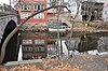 Middlesex Canal Historic and Archeological District Middlesex Canal Historic and Archeological District | November 19, 2009
(#09000936) | Numerous locations along the historic route of the Middlesex Canal
42°25′03″N 71°07′50″W / 42.4175°N 71.1306°W / 42.4175; -71.1306 (Middlesex Canal Historic and Archeological District) | | Extends into other Middlesex County communities and Boston in Suffolk County. |
|---|
| 19 | Middlesex Fells Reservation Parkways | 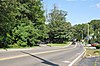 Middlesex Fells Reservation Parkways Middlesex Fells Reservation Parkways | February 4, 2003
(#02001749) | E Border Rd., Fellsway E, Fellsway W, Hillcrest Pky., South St., Pond St., S Border Rd., Ravine Rd., and Woodland Rd.
42°26′43″N 71°06′10″W / 42.445278°N 71.102778°W / 42.445278; -71.102778 (Middlesex Fells Reservation Parkways) | | Included roadways are in Medford, Stoneham,
and Winchester. |
|---|
| 20 | Middlesex Fells Reservoirs Historic District | 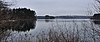 Middlesex Fells Reservoirs Historic District Middlesex Fells Reservoirs Historic District | January 18, 1990
(#89002249) | Roughly bounded by Pond St., Woodland Rd., I-93, and MA 28
42°27′18″N 71°05′43″W / 42.455°N 71.095278°W / 42.455; -71.095278 (Middlesex Fells Reservoirs Historic District) | | Extends into Stoneham. |
|---|
| 21 | Mystic Dam |  Mystic Dam Mystic Dam | January 18, 1990
(#89002282) | Between Lower and Upper Mystic Lakes
42°25′50″N 71°08′56″W / 42.430556°N 71.148889°W / 42.430556; -71.148889 (Mystic Dam) | | Extends between Medford and Arlington; incorrectly listed as being in Winchester |
|---|
| 22 | Mystic Gatehouse | 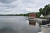 Mystic Gatehouse Mystic Gatehouse | January 18, 1990
(#89002284) | East of Edgewater Pl. on the southeastern end of Upper Mystic Lake
42°25′52″N 71°08′52″W / 42.431111°N 71.147778°W / 42.431111; -71.147778 (Mystic Gatehouse) | | Incorrectly listed as being in Winchester. |
|---|
| 23 | Mystic Valley Parkway, Metropolitan Park System of Greater Boston MPS |  Mystic Valley Parkway, Metropolitan Park System of Greater Boston MPS Mystic Valley Parkway, Metropolitan Park System of Greater Boston MPS | January 18, 2006
(#05001529) | Mystic Valley Parkway
42°25′47″N 71°07′49″W / 42.429722°N 71.130278°W / 42.429722; -71.130278 (Mystic Valley Parkway, Metropolitan Park System of Greater Boston MPS) | | Runs through Arlington,
Medford, Somerville,
and Winchester. |
|---|
| 24 | Edward Oakes House |  Edward Oakes House Edward Oakes House | April 9, 1980
(#80000639) | 5 Sylvia Rd.
42°24′43″N 71°06′39″W / 42.411944°N 71.110833°W / 42.411944; -71.110833 (Edward Oakes House) | | |
|---|
| 25 | Old Medford High School |  Old Medford High School Old Medford High School | October 6, 1983
(#83004068) | 22-24 Forest St.
42°25′15″N 71°06′32″W / 42.420833°N 71.108889°W / 42.420833; -71.108889 (Old Medford High School) | | Now houses condominiums and a community theater. |
|---|
| 26 | Old Ship Street Historic District | 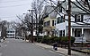 Old Ship Street Historic District Old Ship Street Historic District | April 14, 1975
(#75000279) | Both sides of Pleasant St. from Riverside Ave. to Park St.
42°24′59″N 71°06′06″W / 42.416389°N 71.101667°W / 42.416389; -71.101667 (Old Ship Street Historic District) | | |
|---|
| 27 | Park Street Railroad Station |  Park Street Railroad Station Park Street Railroad Station | April 21, 1975
(#75000280) | 20 Magoun Ave.
42°24′59″N 71°05′55″W / 42.416389°N 71.098611°W / 42.416389; -71.098611 (Park Street Railroad Station) | | Now houses a community service organization. |
|---|
| 28 | Richard Pinkham House |  Richard Pinkham House Richard Pinkham House | January 16, 2008
(#07001399) | 24 Brooks Park
42°24′43″N 71°06′35″W / 42.411944°N 71.109722°W / 42.411944; -71.109722 (Richard Pinkham House) | | |
|---|
| 29 | Revere Beach Parkway-Metropolitan Park System of Greater Boston |  Revere Beach Parkway-Metropolitan Park System of Greater Boston Revere Beach Parkway-Metropolitan Park System of Greater Boston | December 6, 2007
(#07001241) | Revere Beach Pkwy
42°24′16″N 71°01′49″W / 42.404386°N 71.030361°W / 42.404386; -71.030361 (Revere Beach Parkway-Metropolitan Park System of Greater Boston) | | Extends into Everett and Chelsea |
|---|
| 30 | Isaac Royall House | 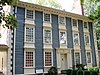 Isaac Royall House Isaac Royall House | October 15, 1966
(#66000786) | 15 George St.
42°24′43″N 71°06′44″W / 42.411944°N 71.112222°W / 42.411944; -71.112222 (Isaac Royall House) | | |
|---|
| 31 | Salem Street Burying Ground |  Salem Street Burying Ground Salem Street Burying Ground | August 27, 1981
(#81000115) | Medford Sq.
42°25′05″N 71°06′27″W / 42.418172°N 71.107614°W / 42.418172; -71.107614 (Salem Street Burying Ground) | | |
|---|
| 32 | Peter Tufts House |  Peter Tufts House Peter Tufts House | November 24, 1968
(#68000044) | 350 Riverside Ave.
42°24′40″N 71°05′39″W / 42.411111°N 71.094167°W / 42.411111; -71.094167 (Peter Tufts House) | | |
|---|
| 33 | Unitarian Universalist Church and Parsonage |  Unitarian Universalist Church and Parsonage Unitarian Universalist Church and Parsonage | April 21, 1975
(#75000281) | 141 and 147 High St.
42°25′13″N 71°06′55″W / 42.420278°N 71.115278°W / 42.420278; -71.115278 (Unitarian Universalist Church and Parsonage) | | |
|---|
| 34 | US Post Office-Medford Main |  US Post Office-Medford Main US Post Office-Medford Main | June 18, 1986
(#86001346) | 20 Forest St.
42°25′08″N 71°06′36″W / 42.418889°N 71.11°W / 42.418889; -71.11 (US Post Office-Medford Main) | | |
|---|
| 35 | John Wade House |  John Wade House John Wade House | June 18, 1975
(#75000282) | 253 High St.
42°25′15″N 71°07′18″W / 42.420833°N 71.121667°W / 42.420833; -71.121667 (John Wade House) | | |
|---|
| 36 | Jonathan Wade House |  Jonathan Wade House Jonathan Wade House | April 21, 1975
(#75000283) | 13 Bradlee Rd.
42°25′08″N 71°06′39″W / 42.418889°N 71.110833°W / 42.418889; -71.110833 (Jonathan Wade House) | | |
|---|


_-_north_facade.JPG)


_facade.JPG)


