
This is a list of ca. 137 volcanoes in Chile. According with archivonacionaldevolcanes.cl[1] there are ca. 500 volcanoes, with 123 active - volcanoes that have erupted at least once in the Holocene. The volcanodb.com lists 109[2] and the Global Volcanism Program lists 105 volcanoes in Chile.[3]
The Pacific islands of Chile are of volcanic origin. They have been formed from magma coming from three distinct hotspots, Easter, Juan Fernández and San Felix hotspots. The westernmost part of the ridges formed by these hotspots contain the most recently active volcanoes. Some volcanoes or groups of volcanoes are under surveillance of OVDAS because of their critical activity or nearness to big cities.
Scope
There is no single standard definition for a volcano. It can be defined from individual vents, volcanic edificies or volcanic fields. Interior of ancient volcanoes may have been eroded, creating a new subsurface magma chamber as a separate volcano. Many contemporary active volcanoes rise as young parasitic cones from flank vents or at a central crater. Some volcanic cones are grouped into one volcano name, for instance, the Tengger caldera complex, although individual vents are named by local people. The status of a volcano, either active or dormant, cannot be defined precisely. An indication of a volcano is determined by either its historical records, radiocarbon dating, or geothermal activities.
The primary source of the list below is taken from the "Volcanoes of the World" book, compiled by two volcanologists Tom Simkin and Lee Siebert,[a] in which active volcanoes in the past 10,000 years (Holocene) are listed.[4]
Groups
Subduction volcanoes in the north
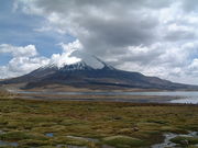 Parinacota and Chungará Lake.
 View of Licancaburs summit.
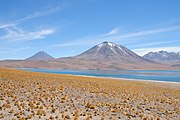 Miscanti and Laguna Miscanti.


Subduction volcanoes in Central and Southern Chile
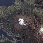 Satellite image of Villarrica, one of Chile's most active volcanoes.
 Aerial view of Sollipulli's ice-clad caldera.
 Aerial view of Cerro Azul.


Subduction and back-arc volcanoes in the Far South
In Chile volcanoes south of 45° are related to the subduction of the Antarctic Plate under the South American plate.
| Name | Shape | Elevation (m) | Last eruption (VEI) | Coordinates |
|---|---|---|---|---|
| Lautaro | stratovolcano | 3,345 | 1979 | 49°01′S 73°33′W / 49.02°S 73.55°W |
| Viedma | Subglacial volcano | 1,500 | 1988 | 49°22′S 73°17′W / 49.36°S 73.28°W |
| Aguilera | stratovolcano | 2,546 | 1650 BC | 50°10′S 73°50′W / 50.17°S 73.83°W |
| Reclus | stratovolcano | 1,000 | 1908 AD ± 1 | 50°59′S 73°42′W / 50.98°S 73.70°W |
| Pali-Aike | volcanic field | 5550 BC ± 1000 | 52°00′S 70°00′W / 52.00°S 70.00°W | |
| Burney | stratovolcano | 1,495 | 1910 | 52°20′S 73°24′W / 52.33°S 73.40°W |
| Fueguino | lava domes | 150 | 1820 | 54°57′S 70°15′W / 54.95°S 70.25°W |
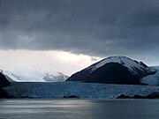 Amalia Glacier with Reclus behind.

Pacific hot spot volcanoes
The Pacific islands of Chile are of volcanic origin. They have been formed from magma coming from three distinct hotspots, Easter, Juan Fernández and San Felix hotspots. The westernmost part of the ridges formed by these hotpots contain the most recently active volcanoes.
| Name | Shape | Elevation (m) | Last eruption (VEI) | Coordinates |
|---|---|---|---|---|
| San Felix[23] | Shield volcano | 183 | Holocene | 26°16′S 80°07′W / 26.27°S 80.12°W |
| Pukao | submarine volcano | 26°57′S 110°16′W / 26.95°S 110.27°W | ||
| Poike, Easter Island | shield volcano | 370 | >1Ma | 27°09′S 109°23′W / 27.15°S 109.38°W |
| Rano Kau, Easter Island | crater lake | 250 | >1Ma | 27°09′S 109°23′W / 27.15°S 109.38°W |
| Terevaka, Easter Island | shield volcano | 507 | >1Ma | 27°09′S 109°23′W / 27.15°S 109.38°W |
| Moai | submarine volcano | 27°06′S 109°51′W / 27.1°S 109.85°W | ||
| Unnamed[24] | submarine volcano | -642 | 33°37′S 76°50′W / 33.62°S 76.83°W | |
| Robinson Crusoe[25] | Shield volcano | 922 | 1835 | 33°39′S 78°51′W / 33.65°S 78.85°W |
| Alexander Selkirk Island | volcanic island | 1,329 | <1Ma | 33°45′S 80°45′W / 33.75°S 80.75°W |
 Rano Kau crater in Easter Island.
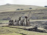 Poike volcano, in the foreground, Ahu Tongariki.
 View of the eroded volcanic island of Robinson Crusoe.


.jpg)
See also
Footnotes
References
- Siebert L, Simkin T (2002–present). Volcanoes of the World: an Illustrated Catalog of Holocene Volcanoes and their Eruptions. Smithsonian Institution, Global Volcanism Program Digital Information Series, GVP-3 (http://www.volcano.si.edu).


External links
- Search Database, Global Volcanism Program
- Search Datebase, VolcanoDB.com