List of metropolitan areas in the Philippines
The Philippines has three metropolitan areas officially recognized by the National Economic and Development Authority (NEDA) due to their prominence, population, size, and economy: Manila, Cebu, and Davao.[1][2] The most populous is Metro Manila, which comprises the City of Manila, 15 neighboring cities, and a municipality. The largest by land area is Metro Davao in Mindanao.
Previously, NEDA recognized ten other metropolitan areas: Metro Angeles, Metro Bacolod, Metro Baguio, Metro Batangas, Metro Cagayan de Oro, Metro Dagupan, Metro Iloilo–Guimaras, Metro Naga, and Metro Olongapo. However, these ten were not included as official metropolises in the 2017–2022 Philippine Development Plan created by NEDA.[3] By 2025, the population of Metro Cagayan de Oro is expected to reach a level that would allow it to be reclassified as a metropolitan area.[4]
The official definition of each metropolitan area, as listed below, does not necessarily follow the actual extent of continuous urbanization. For example, the built-up area of Metro Manila has long spilled out of its borders into the adjacent provinces of Bulacan, Cavite, Laguna, and Rizal.[5]
List
History
In 2020, 54% of the Philippine population lived in urban areas[11] encompassing many cities. Growth in some cities has led to urban spillover in adjacent municipalities.
Metro Manila was created in 1975 with the establishment of the Metro Manila Commission. This commission, reorganized in 1986 as the Metro Manila Authority, was renamed in 1995 as the Metropolitan Manila Development Authority (MMDA). While MMDA has no power over the local government units (LGUs) it covers, it has worked with the LGUs to solve issues that affect all of them such as traffic management.
The practice of creating an intercity board or agency to determine the limits of a metropolitan area has become common.[citation needed] A number of proposals have been created to create similar metropolitan arrangements in other areas of the country. In 1997, Cebu created the Metropolitan Cebu Development Council (MCDC), which was renamed the Metropolitan Cebu Development and Coordinating Board (MCDCB) in 2011. In 2022, Baguio[12] and Davao created their own metropolitan boards. Other proposed metropolitan boards include ones for Bulacan and Bataan.
Gallery
 Metro Manila
 Metro Cebu
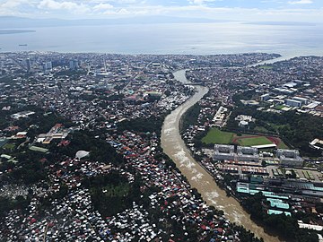 Metro Davao
(2017-11-19).jpg)
.jpg)
_edit.jpg)