

Oorspronkelijk bestand (3.000 × 3.000 pixels, bestandsgrootte: 3,46 MB, MIME-type: image/jpeg)
| Dit is een bestand van Wikimedia Commons. Onderstaande beschrijving komt van de beschrijving van het bestand daar. |
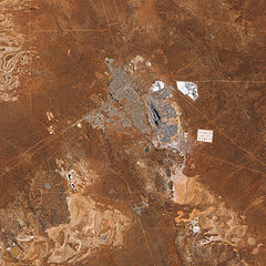
| BeschrijvingSuper Pit Mine, Kalgoorlie, Western Australia.jpg | English: The pit that gives the mine its name appears in the centre of the image, and some of the steep pit’s walls appear in shadow while others are illuminated by the Sun. Related mining operations form a rough semicircle on the eastern side of the pit; a cluster of buildings east-north-east of the pit is Fimiston Mill, where ore is processed. Waste dumps and grey-white tailings ponds sprawl over the arid landscape. Tailings are the rocks and chemicals left over after the gold is extracted. Because the chemicals used to separate gold from rock are often caustic, tailings usually pose hazards to human and/or environmental health and must be treated carefully. The metropolitan area of Kalgoorlie, marked by street grids and manicured green spaces, extends almost to the mine’s central pit. An airport, marked by a long runway, appears along the city’s southern margin. Founded during a late-nineteenth-century gold rush, Kalgoorlie, like the neighboring mine, occurs near an area nicknamed the “Golden Mile,” which is considered especially rich in gold deposits. As the beige and reddish colors in the image indicate, vegetation in the area is sparse. |
| Datum | |
| Bron | NASA Earth Observatory |
| Auteur | Jesse Allen |
Image captured by the Advanced Land Imager (ALI) on NASA’s Earth Observing-1 (EO-1) satellite. Data provided courtesy of the NASA EO-1 team.
| Public domainPublic domainfalsefalse |
| Dit bestand bevindt zich in het publiek domein, omdat het gemaakt is door de NASA. In de reproductierichtlijnen van de NASA staat dat "NASA-materiaal niet beschermd wordt door auteursrecht, tenzij anders vermeld". | ||
 | Waarschuwingen:
|
| Aantekeningen InfoField | Deze afbeelding is aangetekend: Bekijk de aantekeningen op Commons |
Super Pit
Kalgoorlie
Kalgoorlie Boulder Airport
Klik op een datum/tijd om het bestand te zien zoals het destijds was.
| Datum/tijd | Miniatuur | Afmetingen | Gebruiker | Opmerking | |
|---|---|---|---|---|---|
| huidige versie | 22 feb 2010 14:11 | | 3.000 × 3.000 (3,46 MB) | Originalwana | {{Information |Description={{en|1=The pit that gives the mine its name appears in the centre of the image, and some of the steep pit’s walls appear in shadow while others are illuminated by the Sun. Related mining operations form a rough semicir |
Dit bestand wordt op de volgende pagina gebruikt:
De volgende andere wiki's gebruiken dit bestand:
Dit bestand bevat metadata met EXIF-informatie, die door een fotocamera, scanner of fotobewerkingsprogramma toegevoegd kan zijn.
| Gebruikte software | Adobe Photoshop CS3 Macintosh |
|---|---|
| Breedte | 5.251 px |
| Hoogte | 10.441 px |
| Compressiemethode | LZW |
| Pixelcompositie | RGB |
| Oriëntatie | Normaal |
| Aantal componenten | 3 |
| Horizontale resolutie | 1 dpi |
| Verticale resolutie | 1 dpi |
| Gegevensstructuur | planar gegevensformaat |
| Tijdstip laatste bestandswijziging | 18 feb 2010 12:20 |
| Kleurruimte | Ongekalibreerd |