

原始文件 (SVG文件,尺寸为1,520 × 1,059像素,文件大小:210 KB)
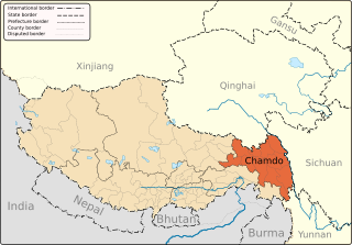
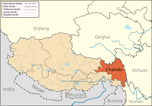
| 描述Qamdo map.svg | English: A map of the administrative boundaries of The Tibetan Autonomous Region with Qamdo (aka Chamdo) Prefecture highlighted. |
| 日期 | |
| 来源 | 自己的作品 |
| 作者 | Keithonearth |
| 其他版本 |
|
| SVG开发 InfoField |
 | 已授权您依据自由软件基金会发行的无固定段落及封面封底文字(Invariant Sections, Front-Cover Texts, and Back-Cover Texts)的GNU自由文件许可协议1.2版或任意后续版本的条款,复制、传播和/或修改本文件。该协议的副本请见“GNU Free Documentation License”。http://www.gnu.org/copyleft/fdl.htmlGFDLGNU Free Documentation Licensetruetrue |
点击某个日期/时间查看对应时刻的文件。
| 日期/时间 | 缩略图 | 大小 | 用户 | 备注 | |
|---|---|---|---|---|---|
| 当前 | 2013年5月7日 (二) 20:32 | | 1,520 × 1,059(210 KB) | Keithonearth | fixing Ngari/Shigatse prefecture boundary as pointed out by user:Fhah4, as per comment here: http://en.wikipedia.org/w/index.php?title=Wikipedia:Graphics_Lab/Map_workshop&diff=541288793&oldid=541266575 |
| 2008年12月31日 (三) 05:07 |  | 1,520 × 1,059(211 KB) | Keithonearth | Changing colour scheme to make more sense, progression from non-highlighted to most highlighted. Category:Tibet | |
| 2008年12月30日 (二) 02:21 |  | 1,520 × 1,059(211 KB) | Keithonearth | {{Information |Description={{en|1=A map of the administrative boundaries of The Tibetan Autonomous Region with Qamdo (aka Chamdo) Prefecture highlighted.}} |Source=Own work by uploader |Author=Keithonearth |Date= |Permission=see belo |
以下其他wiki使用此文件:
查看此文件的更多全域用途。
此文件中包含有扩展的信息。这些信息可能是由数码相机或扫描仪在创建或数字化过程中所添加。
如果此文件的源文件已经被修改,一些信息在修改后的文件中将不能完全反映出来。
| 宽度 | 1520.4525 |
|---|---|
| 高度 | 1059.4189 |


