ಚಿತ್ರ:EasternBloc BorderChange38-48.svg

Size of this PNG preview of this SVG file: ೩೫೨ × ೫೯೮ ಪಿಕ್ಸೆಲ್ಗಳು. ಇತರ ರೆಸಲ್ಯೂಶನ್ಗಳು: ೧೪೧ × ೨೪೦ ಪಿಕ್ಸೆಲ್ಗಳು | ೨೮೨ × ೪೮೦ ಪಿಕ್ಸೆಲ್ಗಳು | ೪೫೨ × ೭೬೮ ಪಿಕ್ಸೆಲ್ಗಳು | ೬೦೨ × ೧,೦೨೪ ಪಿಕ್ಸೆಲ್ಗಳು | ೧,೨೦೪ × ೨,೦೪೮ ಪಿಕ್ಸೆಲ್ಗಳು | ೪೦೦ × ೬೮೦ ಪಿಕ್ಸೆಲ್ಗಳು.
ಮೂಲ ಕಡತ (SVG ಫೈಲು, ಸುಮಾರಾಗಿ ೪೦೦ × ೬೮೦ ಚಿತ್ರಬಿಂದುಗಳು, ಫೈಲಿನ ಗಾತ್ರ: ೧.೩೯ MB)
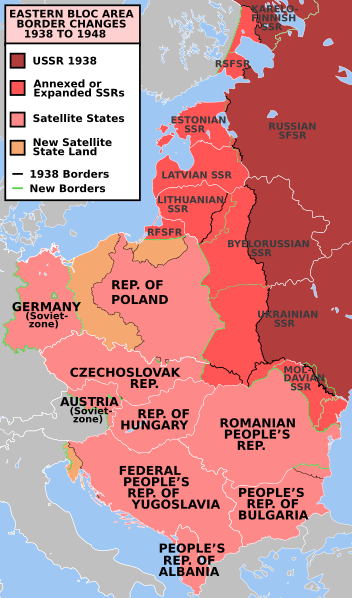
| ವಿವರ | e* Description: Former Eastern Bloc area border changes between 1938 and 1948.
The border and other changes include:
| ||||||||
| ಆಕರ | en.wiki | ||||||||
| ಕರ್ತೃ | Mosedschurte | ||||||||
| ಅನುಮತಿ (ಈ ಕಡತವನ್ನು ಮರುಬಳಕೆ ಮಾಡಲಾಗುತ್ತಿದೆ) |
| ||||||||
| ಇತರೆ ಆವೃತ್ತಿಗಳು | العربيَّة, Türkçe |

ಕಡತದ ಇತಿಹಾಸ
ದಿನ/ಕಾಲ ಒತ್ತಿದರೆ ಆ ಸಮಯದಲ್ಲಿ ಈ ಕಡತದ ವಸ್ತುಸ್ಥಿತಿ ತೋರುತ್ತದೆ.
| ದಿನ/ಕಾಲ | ಕಿರುನೋಟ | ಆಯಾಮಗಳು | ಬಳಕೆದಾರ | ಟಿಪ್ಪಣಿ | |
|---|---|---|---|---|---|
| ಪ್ರಸಕ್ತ | ೦೩:೫೨, ೧೮ ಜುಲೈ ೨೦೨೩ | | ೪೦೦ × ೬೮೦ (೧.೩೯ MB) | Spesh531 | Corrected 1948-Moldavian SSR lines (white -> green). Thinned out 1948 Estonia & Latvia green lines to match the SSR-SSR border thickness |
| ೦೬:೧೨, ೪ ಮಾರ್ಚ್ ೨೦೨೧ |  | ೪೦೦ × ೬೮೦ (೧.೩೮ MB) | Spesh531 | Fixing Czechoslovakia before covered the Austro-Hungarian-Slovak border | |
| ೦೬:೦೯, ೪ ಮಾರ್ಚ್ ೨೦೨೧ |  | ೪೦೦ × ೬೮೦ (೧.೩೮ MB) | Spesh531 | I missed Odessa! Which should be the neutral red like Moldova | |
| ೧೯:೧೫, ೩ ಮಾರ್ಚ್ ೨೦೨೧ |  | ೪೦೦ × ೬೮೦ (೧.೩೭ MB) | Spesh531 | Hiding internal borders of Yugoslavia and Czechoslovakia | |
| ೧೯:೧೦, ೩ ಮಾರ್ಚ್ ೨೦೨೧ |  | ೪೦೦ × ೬೮೦ (೧.೩೩ MB) | Spesh531 | Overhaul of borders. Fixed Julian March. Added Austria occupied zone, Polish-Czech border changes, Austrian/Hungarian/Slovakian tripoint, and better detail in Karelia. | |
| ೦೫:೦೩, ೧೦ ಮಾರ್ಚ್ ೨೦೧೯ |  | ೩೯೬ × ೬೪೩ (೫೮೧ KB) | AndreyKva | Optimized. | |
| ೧೮:೩೭, ೯ ಜನವರಿ ೨೦೧೧ |  | ೩೯೬ × ೬೪೩ (೭೬೫ KB) | Alokasta~commonswiki | Small changes + I changed east border of Poland: On the old version of this map there was the border after Polish-Soviet territorial exchange in 1951. More info: http://en.wikipedia.org/wiki/1951_Polish–Soviet_territorial_exchange | |
| ೧೮:೧೧, ೯ ಜನವರಿ ೨೦೧೧ |  | ೩೯೬ × ೬೪೩ (೭೬೩ KB) | Alokasta~commonswiki | I corrected the polish-german border - in 1938 the Hel Peninsula was the territory of Poland. I changed also the border between Poalnd and Free City of Danzig. I added a white line along the Polish coast. | |
| ೦೭:೫೧, ೧೬ ಸೆಪ್ಟೆಂಬರ್ ೨೦೦೯ |  | ೩೯೬ × ೬೪೩ (೭೪೫ KB) | Stiepan Pietrov | {{Information |Description=e* Description: Former Eastern Bloc area border changes between 1938 and 1948. * Source: Map borders primarily based on [http://commons.wikimedia.org/wiki/File:EC12-1986_European_Community_map.svg] and [http://commons.wikime |
ಕಡತ ಬಳಕೆ
ಈ ಕೆಳಗಿನ ಪುಟವು ಈ ಚಿತ್ರಕ್ಕೆ ಸಂಪರ್ಕ ಹೊಂದಿದೆ:
ಜಾಗತಿಕ ಕಡತ ಉಪಯೋಗ
ಈ ಕಡತವನ್ನು ಕೆಳಗಿನ ಬೇರೆ ವಿಕಿಗಳೂ ಉಪಯೋಗಿಸುತ್ತಿವೆ:
- af.wikipedia.org ಮೇಲೆ ಬಳಕೆ
- ar.wikipedia.org ಮೇಲೆ ಬಳಕೆ
- azb.wikipedia.org ಮೇಲೆ ಬಳಕೆ
- az.wikipedia.org ಮೇಲೆ ಬಳಕೆ
- bg.wikipedia.org ಮೇಲೆ ಬಳಕೆ
- bn.wikipedia.org ಮೇಲೆ ಬಳಕೆ
- ca.wikipedia.org ಮೇಲೆ ಬಳಕೆ
- cs.wikipedia.org ಮೇಲೆ ಬಳಕೆ
- da.wikipedia.org ಮೇಲೆ ಬಳಕೆ
- de.wikipedia.org ಮೇಲೆ ಬಳಕೆ
- el.wikipedia.org ಮೇಲೆ ಬಳಕೆ
- el.wiktionary.org ಮೇಲೆ ಬಳಕೆ
- en.wikipedia.org ಮೇಲೆ ಬಳಕೆ
- Molotov–Ribbentrop Pact
- World War II
- Eastern Bloc
- History of the United States (1945–1964)
- Cold War
- Origins of the Cold War
- History of the Soviet Union (1927–1953)
- Reinhard Gehlen
- List of national border changes (1914–present)
- Aftermath of World War II
- Military occupations by the Soviet Union
- Key events of the 20th century
- Soviet famine of 1946–1947
- Gehlen Organization
- Political warfare
- User:JacksonKo/ideology
- User:Paul Siebert/sandbox
- User:Shafin10555/sandbox
- User:Hmmmmm maybe/sandbox
- Cold War (1947–1948)
- Draft:World War II (Draft)
- User:Falcaorib/Europe
- en.wikiquote.org ಮೇಲೆ ಬಳಕೆ
- eo.wikiquote.org ಮೇಲೆ ಬಳಕೆ
- es.wikipedia.org ಮೇಲೆ ಬಳಕೆ
- et.wikipedia.org ಮೇಲೆ ಬಳಕೆ
- eu.wikipedia.org ಮೇಲೆ ಬಳಕೆ
- fa.wikipedia.org ಮೇಲೆ ಬಳಕೆ
- fi.wikipedia.org ಮೇಲೆ ಬಳಕೆ
- fr.wikipedia.org ಮೇಲೆ ಬಳಕೆ
- gl.wikipedia.org ಮೇಲೆ ಬಳಕೆ
- hif.wikipedia.org ಮೇಲೆ ಬಳಕೆ
- hy.wikipedia.org ಮೇಲೆ ಬಳಕೆ
ಈ ಫೈಲ್ನ ಹೆಚ್ಚು ಜಾಗತಿಕ ಬಳಕೆಯನ್ನು ವೀಕ್ಷಿಸಿ.
ಮೇಲ್ದರ್ಜೆ ಮಾಹಿತಿ
🔥 Top keywords: ಮುಖ್ಯ ಪುಟಕುವೆಂಪುವಿಶೇಷ:Searchಸಹಾಯ:ಲಿಪ್ಯಂತರಕನ್ನಡಗಾದೆಪಿ.ಲಂಕೇಶ್ಬಸವೇಶ್ವರದ.ರಾ.ಬೇಂದ್ರೆಜ್ಞಾನಪೀಠ ಪ್ರಶಸ್ತಿ ಪುರಸ್ಕೃತ ಕನ್ನಡಿಗರುಕನ್ನಡ ಅಕ್ಷರಮಾಲೆಶಿವರಾಮ ಕಾರಂತಭಾರತದ ಸಂವಿಧಾನಕನ್ನಡ ಸಂಧಿಕನ್ನಡ ಗುಣಿತಾಕ್ಷರಗಳುಕರ್ನಾಟಕದ ಏಕೀಕರಣಬಿ. ಆರ್. ಅಂಬೇಡ್ಕರ್ಗೌತಮ ಬುದ್ಧಮಹಾತ್ಮ ಗಾಂಧಿಕರ್ನಾಟಕರಾಘವಾಂಕಕರ್ನಾಟಕದ ಜಿಲ್ಲೆಗಳುಕರ್ನಾಟಕದ ಇತಿಹಾಸವಚನ ಸಾಹಿತ್ಯಪುರಂದರದಾಸರಾಷ್ಟ್ರೀಯ ಸೇವಾ ಯೋಜನೆಮಾಸ್ತಿ ವೆಂಕಟೇಶ ಅಯ್ಯಂಗಾರ್ಹೊಯ್ಸಳಭಾರತೀಯ ಮೂಲಭೂತ ಹಕ್ಕುಗಳುಅಕ್ಕಮಹಾದೇವಿಪೂರ್ಣಚಂದ್ರ ತೇಜಸ್ವಿರಾಮಾಯಣಪಂಪಕನ್ನಡ ಸಾಹಿತ್ಯಅರ್ಜುನಭಾರತೀಯ ಸಂಸ್ಕೃತಿಜಾನಪದಸಮಾಸಜನಪದ ಕಲೆಗಳು