Tập tin:1598 map of the Polar Regions by Willem Barentsz.jpg

Kích thước hình xem trước: 800×592 điểm ảnh. Độ phân giải khác: 320×237 điểm ảnh | 640×474 điểm ảnh | 1.024×758 điểm ảnh | 1.280×948 điểm ảnh | 2.560×1.896 điểm ảnh | 13.719×10.160 điểm ảnh.
Tập tin gốc (13.719×10.160 điểm ảnh, kích thước tập tin: 30,66 MB, kiểu MIME: image/jpeg)
Miêu tả
| Cảnh báo | Một số trình duyệt có thể gặp trở ngại trong việc hiển thị hình này ở cỡ đầy đủ. Hình này có một số lượng điểm ảnh lớn và có thể không được tải chính xác hoặc làm trình duyệt bị treo. |
|---|
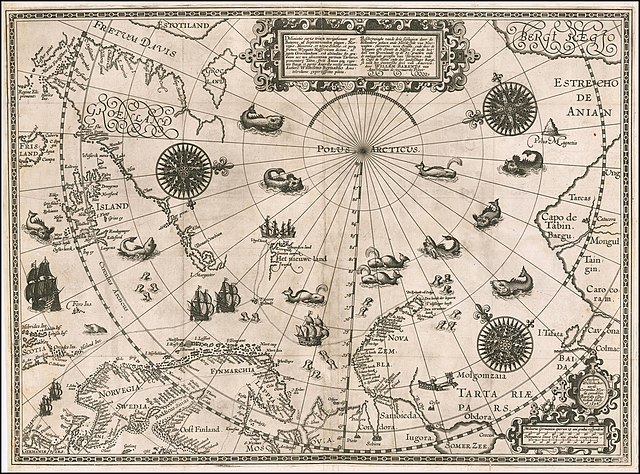
| Miêu tả | English: 1598 map of the Polar Regions by Willem Barentsz Latina: Deliniatio cartae trium navigationum per Batavos, ad Septentrionalem plagam, Norvegiae, Moscoviae, et novae Semblae, et perque fretum Weygatis Nassovicum dictum, ac juxta Groenlandiam, sub altitudine 80. graduum nec non adiacentium partium Tartariae, promontorij Tabin, freti Anian atque regionis Bargi et partis Americae versus orientem, Authore Wilhelmo Bernardo Amstelredamo experissimo pilota. Nederlands: Beschryvinghe vande drie seylagien door de Hollanders gedaen ande Noordt syde van Noorweghen, Moscovia, nova Sembla, ende door de Weygats ofte Strate de Nassou so mede het' deel van Groenlandt op de 80. graeden ende de omleggende grensen van Tartaryen, ende de Capo de Tabin ende des landtschaps Bargi, so oock het Oostersche deel van America: door Willem Barents van Amstelredam de vermaerde Piloot |
| Ngày | |
| Nguồn gốc | Barry Lawrence Rare Maps, from an original 1598 print. |
| Tác giả | Original charts by Willem Barentsz, map drawn by Cornelis Claesz ("Cornelius Nicolai"), engraved by Baptista van Doetecum ("Baptista a Doetechum") |
| Phiên bản khác |
|
.jpg)

_door_Willem_Barendsz_(titel_op_object),_NG-800.jpg)


Giấy phép
Tác phẩm này thuộc về phạm vi công cộng tại quốc gia gốc và các quốc gia và vùng lãnh thổ có thời hạn bản quyền là cuộc đời tác giả cộng thêm 70 trở xuống. Tác phẩm này thuộc về phạm vi công cộng ở Hoa Kỳ vì nó được phát hành trước ngày 1 tháng 1 năm 1929. | |
| Tập tin này đã được đánh dấu là không bị hạn chế dưới luật bản quyền, kể cả tất cả những quyền liên quan và lần cận. | |
| Annotations | This image is annotated: View the annotations at Commons |
Lịch sử tập tin
Nhấn vào ngày/giờ để xem nội dung tập tin tại thời điểm đó.
| Ngày/giờ | Hình xem trước | Kích cỡ | Thành viên | Miêu tả | |
|---|---|---|---|---|---|
| hiện tại | 18:42, ngày 22 tháng 3 năm 2020 | | 13.719×10.160 (30,66 MB) | Balkanique | Uploaded a work by Willem Barentsz from https://www.raremaps.com/gallery/detail/59238/deliniatio-cartae-trium-navigationum-per-batavos-ad-septent-barentsz with UploadWizard |
Trang sử dụng tập tin
Có 1 trang tại Wikipedia tiếng Việt có liên kết đến tập tin (không hiển thị trang ở các dự án khác):
Sử dụng tập tin toàn cục
Những wiki sau đang sử dụng tập tin này:
- Trang sử dụng tại ar.wikipedia.org
- Trang sử dụng tại ast.wikipedia.org
- Trang sử dụng tại ca.wikipedia.org
- Trang sử dụng tại cs.wikipedia.org
- Trang sử dụng tại da.wikipedia.org
- Trang sử dụng tại de.wikipedia.org
- Trang sử dụng tại en.wikipedia.org
- Trang sử dụng tại es.wikipedia.org
- Trang sử dụng tại fr.wikipedia.org
- Trang sử dụng tại hy.wikipedia.org
- Trang sử dụng tại is.wikipedia.org
- Trang sử dụng tại it.wikipedia.org
- Trang sử dụng tại ja.wikipedia.org
- Trang sử dụng tại la.wikipedia.org
- Trang sử dụng tại nl.wikipedia.org
- Trang sử dụng tại no.wikipedia.org
- Trang sử dụng tại pl.wikipedia.org
- Trang sử dụng tại pt.wikipedia.org
- Trang sử dụng tại sl.wikipedia.org
- Trang sử dụng tại sr.wikipedia.org
- Trang sử dụng tại uk.wikipedia.org
- Trang sử dụng tại zh.wikipedia.org
🔥 Top keywords: Đài Truyền hình Kỹ thuật số VTCTrang ChínhGiỗ Tổ Hùng VươngTrương Mỹ LanĐặc biệt:Tìm kiếmHùng VươngVương Đình HuệUEFA Champions LeagueKuwaitChiến dịch Điện Biên PhủFacebookĐài Truyền hình Việt NamTrần Cẩm TúĐội tuyển bóng đá quốc gia KuwaitGoogle DịchViệt NamCúp bóng đá U-23 châu ÁCúp bóng đá U-23 châu Á 2024Real Madrid CFBảng xếp hạng bóng đá nam FIFACleopatra VIITô LâmTim CookNguyễn Phú TrọngHồ Chí MinhHai Bà TrưngManchester City F.C.VnExpressChủ tịch nước Cộng hòa xã hội chủ nghĩa Việt NamNguyễn Ngọc ThắngĐền HùngCúp bóng đá trong nhà châu Á 2024Võ Văn ThưởngOne PieceLịch sử Việt NamCuộc đua xe đạp toàn quốc tranh Cúp truyền hình Thành phố Hồ Chí Minh 2024Phạm Minh ChínhTikTokĐinh Tiên Hoàng