Tập tin:Baghdad etm 2003092 lrg.jpg

Kích thước hình xem trước: 444×599 điểm ảnh. Độ phân giải khác: 178×240 điểm ảnh | 355×480 điểm ảnh | 889×1.200 điểm ảnh.
Tập tin gốc (889×1.200 điểm ảnh, kích thước tập tin: 458 kB, kiểu MIME: image/jpeg)
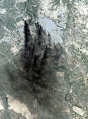
| Miêu tả | This image shows the city of Baghdad, the capital of Iraq. The dark smoke plumes are from pits of burning oil arrayed in a ring around the center of the city, a tactic used to stall and confuse invaders since medieval times. This picture is computer animated to show how it could look in reality. Baghdad Airport can be seen southwest of the city, just outside the smoke. This image was acquired by Landsat 7's Enhanced Thematic Mapper Plus (ETM+) sensor on April 2, 2003. | |||||
| Ngày | Image taken on April 2, 2003. | |||||
| Nguồn gốc | http://earthobservatory.nasa.gov/NaturalHazards/natural_hazards_v2.php3?img_id=10149 | |||||
| Tác giả | Image provided by the USGS EROS Data Center Satellite Systems Branch. | |||||
| Giấy phép (Dùng lại tập tin) |
|

Lịch sử tập tin
Nhấn vào ngày/giờ để xem nội dung tập tin tại thời điểm đó.
| Ngày/giờ | Hình xem trước | Kích cỡ | Thành viên | Miêu tả | |
|---|---|---|---|---|---|
| hiện tại | 05:58, ngày 9 tháng 1 năm 2006 | | 889×1.200 (458 kB) | Slarre~commonswiki | This image shows the city of Baghdad, the capital of Iraq. The dark smoke plumes are from pits of burning oil arrayed in a ring around the center of the city, a tactic used to stall and confuse invaders since medieval times. Baghdad Airport can be seen so |
Trang sử dụng tập tin
Có 2 trang tại Wikipedia tiếng Việt có liên kết đến tập tin (không hiển thị trang ở các dự án khác):
Sử dụng tập tin toàn cục
Những wiki sau đang sử dụng tập tin này:
- Trang sử dụng tại bg.wikipedia.org
- Trang sử dụng tại ca.wikipedia.org
- Trang sử dụng tại cs.wikipedia.org
- Trang sử dụng tại cy.wikipedia.org
- Trang sử dụng tại da.wikipedia.org
- Trang sử dụng tại de.wikipedia.org
- Trang sử dụng tại en.wikipedia.org
- Trang sử dụng tại en.wikiquote.org
- Trang sử dụng tại es.wikipedia.org
- Trang sử dụng tại fi.wikipedia.org
- Trang sử dụng tại fr.wikipedia.org
- Trang sử dụng tại he.wikipedia.org
- Trang sử dụng tại ko.wikipedia.org
- Trang sử dụng tại no.wikipedia.org
- Trang sử dụng tại pt.wikipedia.org
- Trang sử dụng tại ru.wikipedia.org
- Trang sử dụng tại sv.wikipedia.org
- Trang sử dụng tại tr.wikipedia.org
- Trang sử dụng tại uk.wikipedia.org
- Trang sử dụng tại zh-classical.wikipedia.org
- Trang sử dụng tại zh.wikipedia.org
Đặc tính hình
🔥 Top keywords: Đài Truyền hình Kỹ thuật số VTCTrang ChínhGiỗ Tổ Hùng VươngTrương Mỹ LanĐặc biệt:Tìm kiếmHùng VươngVương Đình HuệUEFA Champions LeagueKuwaitChiến dịch Điện Biên PhủFacebookĐài Truyền hình Việt NamTrần Cẩm TúĐội tuyển bóng đá quốc gia KuwaitGoogle DịchViệt NamCúp bóng đá U-23 châu ÁCúp bóng đá U-23 châu Á 2024Real Madrid CFBảng xếp hạng bóng đá nam FIFACleopatra VIITô LâmTim CookNguyễn Phú TrọngHồ Chí MinhHai Bà TrưngManchester City F.C.VnExpressChủ tịch nước Cộng hòa xã hội chủ nghĩa Việt NamNguyễn Ngọc ThắngĐền HùngCúp bóng đá trong nhà châu Á 2024Võ Văn ThưởngOne PieceLịch sử Việt NamCuộc đua xe đạp toàn quốc tranh Cúp truyền hình Thành phố Hồ Chí Minh 2024Phạm Minh ChínhTikTokĐinh Tiên Hoàng