

Tập tin gốc (tập tin SVG, 512×158 điểm ảnh trên danh nghĩa, kích thước: 592 kB)
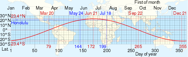
| Miêu tảSubsolar point date graph.svg | English: Approximate dates when the solar zenith angle reaches a minimum of 0 degrees vs latitude by CMG Lee superimposed on an equirectangular world map from http://commons.wikimedia.org/wiki/File:World_location_map.svg by STyx. The example in blue shows the dates of Lahaina Noon at Honolulu, Hawaii, USA. The red curve is obtained from the Declination of the Sun equation δ=-23.45°*cos[360°/365*(N+10)], where, δ is the Declination of the Sun in ° latitude, N is the day of the year ranging from 1 to 365. | |
| Ngày | ||
| Nguồn gốc |
| |
| Tác giả | cmglee, STyx et al |
Nhấn vào ngày/giờ để xem nội dung tập tin tại thời điểm đó.
| Ngày/giờ | Hình xem trước | Kích cỡ | Thành viên | Miêu tả | |
|---|---|---|---|---|---|
| hiện tại | 17:02, ngày 20 tháng 6 năm 2021 | 512×158 (592 kB) | Cmglee | Add 5° latitude gridlines | |
| 16:16, ngày 20 tháng 6 năm 2021 | 512×158 (592 kB) | Cmglee | Expand map to fill image | ||
| 16:06, ngày 20 tháng 6 năm 2021 | 512×158 (592 kB) | Cmglee | Uploaded a work by cmglee, STyx et al from {{source thumb|world_location_map.svg}} with UploadWizard |
Những wiki sau đang sử dụng tập tin này:
Tập tin này chứa thông tin bổ sung, có thể được thêm từ máy ảnh kỹ thuật số hoặc máy quét được sử dụng để tạo hoặc số hóa tệp.
Nếu tập tin đã được sửa đổi so với trạng thái ban đầu, một số chi tiết có thể không phản ánh đầy đủ tập tin đã sửa đổi.
| Tên ngắn | subsolar point date graph |
|---|---|
| Tiêu đề của hình | Approximate dates when the solar zenith angle reaches a minimum of 0 degrees vs latitude by CMG Lee superimposed on an equirectangular world map from http://commons.wikimedia.org/wiki/File:World_location_map.svg by STyx. The example in blue shows the dates of Lahaina Noon at Honolulu, Hawaii, USA. |
| Chiều ngang | 100% |
| Chiều cao | 100% |
