Lidar
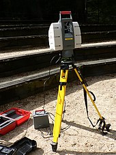
Lidar (ing-gú: Lidar /ˈlaɪdɑːr/, iah kiò-tsò LIDAR, hi̍k-tsiá LiDAR; ū-tang-sî-á kiò-tsò LADAR; Kong-ha̍k luî-ta̍t) sī "Kong-kiám kah tshik-kū"[1] hi̍k-tsiá "kik-kong sîng-siōng, kiám-tshik kah tshik-kū" ê sok-siá.[2] Lidar sī -tsióng tsi̍t thong-kuè iōng kik-kong biâu-tsún bu̍t-thé hi̍k-tsiá piáu-bīn, lî-tshiánn tshik-liông huán-siā-kng huán-tńg--lâi tsiap-siu-khì ê sî-kan lâi khak-tīng huān-uî (pīng-tshiánn ē-tàng kái-piàn kī-lî) ê hong-huat. Lidar ū-tang-sî-á hông kiò-tsò 3-D kik-kong sàu-biâu, sī 3-D sàu-biâu hām kik-kong sàu-biâu ê ti̍k-sû tsoo-ha̍p.[3] Lidar kū-iú tē-bīn, ki-tsài kah î-tōng ê ìng-iōng.[4][5]


Lidar thong-siông iōng-teh tsè-tsō ko hun-piān-lu̍t tē-tôo, teh tshik-liông, tāi-tē tshik-liông-ha̍k, tshik-huē-ha̍k, khó-kóo-ha̍k, tē-lí-ha̍k, tē-tsit-ha̍k, tē-māu-ha̍k, tē-tsìn-tōng-ha̍k, lîm-gia̍p, tāi-khì bu̍t-lí-ha̍k,[6] luî-siā tsè-tō, "ki-tsài kik-kong ki-tshik-huē" (ALSM) kah kik-kong tshik-kuân. Lidar iah-koh ū iōng-teh bóo tsi̍t-kuá-á tsú-tōng kà-sú khì-tshia[7] ê khòng-tsè hām tō-hâng; í-ki̍p teh hué-tshenn tē-hîng tíng-kuân tshòng-kì-lio̍k hui-hîng ê Ingenuity ti̍t-sing-ki.[8]
Tsù-kái
Ên-sin ua̍t-to̍k
Tsham-ua̍t
- Khì-siōng gî-khì
- Atomic line filter – Optical band-pass filter used in the physical sciences
- Ceilometer – Ground-based lidar for cloud height measurement
- Clear-air turbulence – Turbulent movement of transparent air masses without any visual cues
- CLidar
- Geodimeter
- Geological structure measurement by LiDAR – Terrain measurement with light beams
- Laser rangefinder – Range finding device that uses a laser beam to determine the distance to an object
- LAS file format
- libLAS – BSD-licensed C++ library for reading/writing ASPRS LAS lidar data
- Lidar detector
- List of laser articles
- National lidar dataset (all countries)
- National Lidar Dataset (United States)
- Optech
- Optical heterodyne detection
- Optical time-domain reflectometer
- Photogrammetry – Taking measurements using photography
- Range imaging – Technique which produces a 2D image showing the distance to points in a scene from a specific point
- Satellite laser ranging
- Seafloor mapping#LiDAR
- SODAR
- Time-domain reflectometry
- TopoFlight
Guā-pōo liân-kiat
- National Oceanic and Atmospheric Administration (NOAA) (15 April 2020). "What is LIDAR?". NOAA's National Ocean Service.
- The USGS Center for LIDAR Information Coordination and Knowledge (CLICK) – A website intended to "facilitate data access, user coordination and education of lidar remote sensing for scientific needs."
