

原始文件 (700 × 640像素,文件大小:299 KB,MIME类型:image/png)
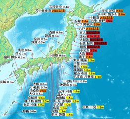
| 描述2011 Tohoku earthquake observed tsunami heights.png | English: Map of 2011 Tohoku(Sendai) earthquake observed tsunami heights in Japan. 日本語: 東北地方太平洋沖地震で観測された、日本各地の津波の高さ。 |
| 日期 | |
| 来源 | JMA1, 2, 3, 4, map:demis |
| 作者 | own work |
| 其他版本 | SVG再構成版が利用できます。(SVG version available) |
| Public domainPublic domainfalsefalse |
This image is in the public domain because it came from the site https://www.demis.nl/products/web-map-server/examples/ and was released by the copyright holder. Permission is granted to copy, distribute and/or modify this map since it is based on free of copyright images from: www.demis.nl. See also approval email on de.wp and its clarification. Deutsch | English | македонски | മലയാളം | Nederlands | slovenščina | +/− |
| Public domainPublic domainfalsefalse |
| This work has been released into the public domain by its copyright holder, www.demis.nl. This applies worldwide. 在一些国家这可能不合法;如果是这样的话,那么: www.demis.nl无条件地授予任何人以任何目的使用本作品的权利,除非这些条件是法律规定所必需的。 Public domainPublic domainfalsefalse |
点击某个日期/时间查看对应时刻的文件。
| 日期/时间 | 缩略图 | 大小 | 用户 | 备注 | |
|---|---|---|---|---|---|
| 当前 | 2011年4月29日 (五) 10:47 | | 700 × 640(299 KB) | Pekachu | 相馬の津波高さ変更に伴う修正([http://www.jma.go.jp/jma/press/1104/13a/201104131600.html JMA press]) |
| 2011年4月2日 (六) 13:38 |  | 700 × 640(299 KB) | Pekachu | 着色間違いを訂正 | |
| 2011年4月2日 (六) 13:22 |  | 700 × 640(299 KB) | Pekachu | {{Information |Description ={{en|1=Map of 2011 Tohoku(Sendai) earthquake observed tsunami heights in Japan.}} {{ja|1=東北地方太平洋沖地震で観測された、日本各地の |
以下2个页面使用本文件:
以下其他wiki使用此文件:
此文件中包含有扩展的信息。这些信息可能是由数码相机或扫描仪在创建或数字化过程中所添加。
如果此文件的源文件已经被修改,一些信息在修改后的文件中将不能完全反映出来。
| 水平分辨率 | 37.79 dpc |
|---|---|
| 垂直分辨率 | 37.79 dpc |