Lêer:Corpses in the courtyard of Nordhausen concentration camp.jpg

Grootte van hierdie voorskou: 768 × 599 piksels. Ander resolusies: 308 × 240 piksels | 615 × 480 piksels | 984 × 768 piksels | 1 280 × 999 piksels | 2 560 × 1 998 piksels | 3 000 × 2 341 piksels.
Oorspronklike lêer (3 000 × 2 341 piksels, lêergrootte: 1,24 MG, MIME-tipe: image/jpeg)
Opsomming =
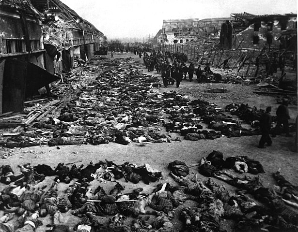
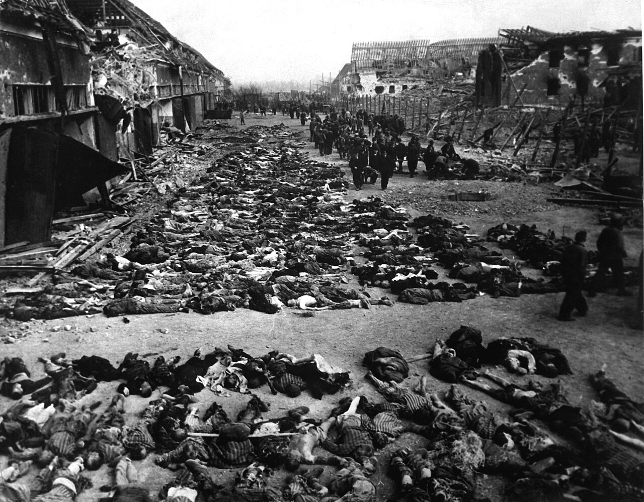
| Beskrywing | English: Aftermath of the British bombing raid of 3 and 4 April 1945 that destroyed the Boelcke-Kaserne (Boelcke Barracks) located in the south-east of the town of Nordhausen and killed around 1300 inmates. The barracks was a subcamp of the Mittelbau-Dora Nazi concentration camp. Used as an overflow camp for sick and dying inmates from January 1945, numbers rose from a few hundred to over 6000, and the conditions saw up to 100 inmates die every day. The camp was named after Oswald Boelke. עברית: שורות של גופות מאות אסירים בחצר מחצה הריכוז נורדהאוזן. בתמונה נראות פחות ממחצית הגופות של האסירים שמתו ברעב או ביריות אנשי הגסטפו. Italiano: 12 aprile 1945, le Boelcke-Kaserne (baracche Boelcke) a sud-est della città di Nordhaushen, bombardate fra il 3 e il 4 aprile 1945 dall'aviazione britannica causando la morte di 1300 prigionieri. Le baracche costituivano un sottocampo del campo di Mittelbau-Dora. Vi venivano reclusi i moribondi del campo e a partire dal gennaio del 1945 il loro numero crebbe da qualche centinaio a oltre seimila, con una mortalità che arrivava a cento persone al giorno. | |||
| Datum | ||||
| Bron |
| |||
| Outeur | T4c. James E Myers | |||
| Toestemming (Hergebruik van die lêer) |
| |||
| Ander weergawes |  |

| Kameraligging | | Hierdie en ander beelde in: OpenStreetMap |
|---|
|
Lêergeskiedenis
Klik op die datum/tyd om te sien hoe die lêer destyds gelyk het.
| Datum/Tyd | Duimnael | Dimensies | Gebruiker | Opmerking | |
|---|---|---|---|---|---|
| huidig | 02:49, 24 September 2018 | | 3 000 × 2 341 (1,24 MG) | Buidhe | Reverted to version as of 07:58, 19 April 2018 (UTC) |
| 02:49, 24 September 2018 |  | 600 × 461 (87 KG) | Buidhe | Better quality image | |
| 07:58, 19 April 2018 |  | 3 000 × 2 341 (1,24 MG) | Migebert | Reverted to version as of 13:53, 22 November 2008 (UTC) | |
| 07:10, 19 April 2018 |  | 600 × 483 (331 KG) | Brilsvonkarloff | Reverted to version as of 12:34, 22 August 2005 (UTC) | |
| 13:53, 22 November 2008 |  | 3 000 × 2 341 (1,24 MG) | Movieevery | higher res from http://www.defenseimagery.mil | |
| 12:34, 22 Augustus 2005 |  | 600 × 483 (331 KG) | Petrusbarbygere | Rows of bodies of dead inmates fill the yard of Lager Nordhausen, a Gestapo concentration camp. This photo shows less than half of the bodies of the several hundred inmates who died of starvation or were shot by Gestapo men. Germany, 04/12/1945 Source: h |
Lêergebruik
Die volgende bladsy gebruik dié lêer:
Globale lêergebruik
Die volgende ander wiki's gebruik hierdie lêer:
- Gebruik in ang.wikipedia.org
- Gebruik in arc.wikipedia.org
- Gebruik in ar.wikipedia.org
- نازية
- الهولوكوست
- قالب:الهولوكوست صندوق جانبي
- اضطهاد الكنيسة الكاثوليكية على يد النازية
- اتفاقية التعويضات بين إسرائيل وألمانيا الغربية
- الهولوكوست في بولندا
- الهولوكوست في سلوفاكيا
- الهولوكوست في لاتفيا
- الهولوكوست في إيطاليا
- الهولوكوست في النرويج
- الهولوكوست في بيلاروس
- الهولوكوست في أوكرانيا
- الهولوكوست في صربيا
- الهولوكوست في المجر
- الهولوكوست في إستونيا
- المسؤولية عن الهولوكوست
- جرائم الحرب في بولندا المحتلة خلال الحرب العالمية الثانية
- تاريخ اليهود في الحرب العالمية الثانية
- الناجون من الهولوكوست
- الهولوكوست في اليونان
- Gebruik in arz.wikipedia.org
- Gebruik in ast.wikipedia.org
- Gebruik in bat-smg.wikipedia.org
- Gebruik in be.wikipedia.org
- Gebruik in bn.wikipedia.org
- Gebruik in br.wikipedia.org
- Gebruik in bxr.wikipedia.org
- Gebruik in cy.wikipedia.org
- Gebruik in da.wikipedia.org
- Gebruik in de.wikipedia.org
- Gebruik in diq.wikipedia.org
- Gebruik in en.wikipedia.org
Wys meer globale gebruik van die lêer.
Metadata
🔥 Top keywords: Spesiaal:SoekTuisbladPornhubMediese diagnoseAardverwarmingSpesiaal:Onlangse wysigingsTrappe van vergelykingAntoniemSuid-AfrikaApartheidNazi-DuitslandTropiese sikloonCarles PuigdemontErfenisdag (Suid-Afrika)AardbewingGeweldVergelykings (taalkunde)Intensiewe vormGetalMieliestronkDroogteNelson MandelaErfenisAfkortingBoelierySwangerskapNasionale erfenisterreine van Suid-AfrikaLionel PetersonMenseregteVoornaamwoordHolocaustBynierWaarheid-en-versoeningskommissieSelfstandige naamwoordMarie AntoinetteByvoeglike naamwoordWikipediaRobbeneilandWikipedia:Gebruikersportaal