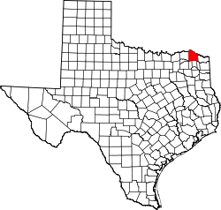
Red River County, Texas
(Weidagloadt vo Red River County)
Red River County[1] is a County im Bundesstoot Texas. Da Vawoitungsitz (County Seat) is z Clarksville.[2]
| Vawoitung | |
|---|---|
| US-Bundesstoot: | Texas |
| Sitz vo da Vawoitung: | Clarksville |
| Adress vom Vawoitungssitz: | Red River County Courthouse Annex 200 N. Walnut Street Clarksville, TX 75426-3041 |
| Grindung: | 1837 |
| Buidt aus: | Red River Distrikt |
| Vuawoi: | 001 903 |
| Demographie | |
| Eihwohna: | 12.860 (2010) |
| Dichtn: | 4,7 Eihwohna/km² |
| Eadkund | |
| Flächn gesamt: | 2.739 km² |
| Wossaflächn: | 19 km² |
| Koartn | |
 | |
| Hoamseitn: www.co.red-river.tx.us | |
Geographie
Des County liegt im Nordostn vo Texas am Red River der de Grenz zu Oklahoma buidt. Im Nordostn is da Staat Arkansas uma 10 km entfeant. Des Red River County hod a Flächn vo 2739 Quadratkilometa, wovo 19 Quadratkilometa Wossaflächn san.
Es grenzt an foignde Nochboacountys:
| Choctaw County (Oklahoma) | McCurtain County (Oklahoma) | |
| Lamar County |  | Bowie County |
| Delta County | Franklin County, Titus County | Morris County |
Gmoana
Citys
| Towns
|
- Bagwell
- English
- Maple
- Negley
1 - teiweis im Lamar County
- weidane Oatschoftn
- Acworth
- Addielou
- Albion
- Blakeney
- Boxelder
- Cuthand
- Davenport
- Dimple
- Fulbright
- Greenwood
- Halesboro
- Johntown
- Kanawha
- Kiomatia
- Lydia
- Mabry
- Manchester
- Peters Prairie
- Rosalie
- Rugby
- Shadowland
- Sherry
- Silver City
- Vandalia
- White Rock
- Woodland
Beleg
Im Netz
 Commons: Red River County, Texas – Sammlung vo Buidl, Videos und Audiodateien
- Offizielle Webseite
- Yahoo Bildersuche - Red River County
- www.city-data.com - Red River County
- Handbuch von Texas - Red River County
- "Red River County Profile" der Texas Association of Counties (engl.)
Countys im Bundesstoot Texas
🔥 Top keywords: Wikipedia:HoamseitnWikipedia:ImpressumMingaSpezial:SucheSpruch:Boarische SpruchsammlungSpruch:Boarische FluachsammlungWikipedia:AutornPortalWikipedia:Iba WikipediaBoarischZwoata WödkriagHuif:HilfeWikipedia:GriaßdeWikipediaDe boarische WochaHabedereURL-EncodingSpezial:Letzte ÄnderungenSuachmaschinoptimiarungBayernFotznOachkatzlGmaade WiesnGeorgienWikipedia:ArtiklgruppnText:StartFeitlWikipedia:StammdischÖstareichWestmittelbairischBeziake im KosovoSteiamoakHawaraGspusiSaudi ArabienPeriodnsystemBasst schoSowjetunionVorsätze für MaßeinheitenMarc Seibold

