Cruzeiro do Sul (Portuguese pronunciation: [kɾuˈzejɾu du ˈsuw], Southern Cross) is a municipality located on the Juruá river in the west of the Brazilian state of Acre. It is the second-largest city in Acre.
Cruzeiro do Sul | |
|---|---|
| Municipality of Cruzeiro do Sul | |
 City centre, Catedral Nossa Senhora da Glória, alongside Juruá River, Acre, Brazil. | |
.svg) Flag  Seal | |
| Nickname: Land of the Nahuas (Portuguese: Terra dos Nauas) | |
 Location in Acre | |
 Cruzeiro do Sul Location in Brazil | |
| Coordinates: 7°37′51″S 72°40′12″W / 7.63083°S 72.67000°W | |
| Country | |
| Region | North |
| State | |
| Founded | September 12, 1904 |
| Government | |
| • Mayor | Ilderlei Cordeiro (MDB) |
| Area | |
| • Total | 7,924.943 km2 (3,059.838 sq mi) |
| Elevation | 182 m (597 ft) |
| Population (2020 est) | |
| • Total | 89,072 |
| • Density | 8.94/km2 (23.2/sq mi) |
| Demonym | cruzeirense[1] |
| Time zone | UTC−5 (ACT) |
| CEP postal code | 69980-000 |
| Area code | +55 68 |
| HDI (2010) | 0.664 – medium[2] |
| Website | cruzeirodosul |
It is bordered to the north by the state of Amazonas, to the south by Peru, to the east by the municipality of Porto Walter, to the west by the municipality of Rodrigues Alves, to the northwest by the municipality of Tarauacá, and to the northwest by the municipality of Mâncio Lima.
The municipality contains 23% of the 846,633 hectares (2,092,080 acres) Serra do Divisor National Park, created in 1989.[3]
Economy and buildings

The principal economic activity of the municipality is rubber extraction and export, as it was in the majority of the state of Acre. This business attracted many immigrants in the 20th century, including Germans. Of lesser importance is the farming of the commodities of cassava, coffee and rice. The city also operates as a regional trading center.
One of the city's most notable 20th-century structures is the Catedral Nossa Senhora da Glória. The parish was founded in 1915 by Spiritan priests, who established the first church in the Juruá valley. With more settlers, the territory was divided in 1930 and German priests were assigned to this area of the Upper Juruá.[4]
Their influence was shown in the design of the current cathedral, which was begun in 1957; it opened in 1965. Its roof structure is said to be similar to a church in Cologne, Germany. The roof was constructed on site and raised by the workers. In 2015 the parish's centenary was celebrated with an exhibition of historic photographs and related lectures.[4]
Transport
The town is served by Cruzeiro do Sul International Airport.[5][6] The town is about 630 kilometres from Rio Branco by road, through the BR-364.[7]
Geography
The urban area of Cruzeiro do Sun has a size of 24.794 square kilometres (9.573 sq mi).[8]
Climate

Although the town has a tropical climate typical of Acre and the Amazon region (Köppen Am, bordering on Af as July receives just under 60 millimetres (2.4 in) of rainfall) it is notable for sporadic cold spells not typically found in low-lying equatorial areas. The temperature has twice dropped below 2.4 °C (36.3 °F), once in May and once in November. The coldest temperature ever recorded is 2.2 °C (36.0 °F) and the warmest is 43.3 °C (109.9 °F). The warmest month by average temperature is October at 26.0 °C (78.8 °F), while the warmest month by average high is September at 32.8 °C (91.0 °F). The coolest months by the average temperature are June and July at 24.8 °C (76.6 °F), while the coolest month by average low is July at 18.6 °C (65.5 °F). The average annual temperature is 25.6 °C (78.1 °F). The average high temperature is 31.8 °C (89.2 °F), and all months have an average high above 30 °C (86 °F). This, combined with the high humidity year-round, leads to sweltering days.
Cruzeiro do Sul receives 2,167.4 millimetres (85.33 in) on average annually and has a wet season that generally falls between October and April and a drier season from June to September. March, receiving 292.6 millimetres (11.52 in) of rainfall on average, is the wettest month, while July is the driest month, receiving only 59.1 millimetres (2.33 in) of rainfall. The wet season has 14-18 precipitation days on average, while the dry season has 6-8 precipitation days on average. March has the most precipitation days and July and August have the least. Humidity is high year round, but drops below 80% from July to September. Even for a rainforest location, sunshine is unusually low, with the city only receiving an average of 1337.5 hours of sunshine annually. This is even lower than places such as London. For comparison, Manaus receives 1,774.8 hours of sunshine despite being wetter.[9] Sunshine is lowest from January to March, and it rises during the dry season. July is the sunniest month, receiving 182.3 hours of sunshine.
| Climate data for Cruzeiro do Sul, Acre (1981–2010, extremes 1941–present) | |||||||||||||
|---|---|---|---|---|---|---|---|---|---|---|---|---|---|
| Month | Jan | Feb | Mar | Apr | May | Jun | Jul | Aug | Sep | Oct | Nov | Dec | Year |
| Record high °C (°F) | 36.6 (97.9) | 36.8 (98.2) | 39.0 (102.2) | 38.5 (101.3) | 39.9 (103.8) | 38.0 (100.4) | 37.2 (99.0) | 43.3 (109.9) | 42.7 (108.9) | 38.7 (101.7) | 37.8 (100.0) | 38.8 (101.8) | 43.3 (109.9) |
| Mean daily maximum °C (°F) | 31.5 (88.7) | 31.5 (88.7) | 31.6 (88.9) | 31.5 (88.7) | 31.0 (87.8) | 30.9 (87.6) | 31.5 (88.7) | 32.5 (90.5) | 32.8 (91.0) | 32.7 (90.9) | 32.0 (89.6) | 31.6 (88.9) | 31.8 (89.2) |
| Daily mean °C (°F) | 25.9 (78.6) | 25.7 (78.3) | 25.7 (78.3) | 25.7 (78.3) | 25.1 (77.2) | 24.8 (76.6) | 24.8 (76.6) | 25.5 (77.9) | 25.8 (78.4) | 26.0 (78.8) | 25.8 (78.4) | 25.8 (78.4) | 25.6 (78.1) |
| Mean daily minimum °C (°F) | 21.3 (70.3) | 21.2 (70.2) | 21.3 (70.3) | 21.1 (70.0) | 20.3 (68.5) | 19.3 (66.7) | 18.6 (65.5) | 19.2 (66.6) | 20.0 (68.0) | 20.9 (69.6) | 21.0 (69.8) | 21.2 (70.2) | 20.5 (68.9) |
| Record low °C (°F) | 10.7 (51.3) | 10.1 (50.2) | 9.8 (49.6) | 11.3 (52.3) | 2.3 (36.1) | 6.2 (43.2) | 7.1 (44.8) | 6.9 (44.4) | 6.8 (44.2) | 8.1 (46.6) | 2.2 (36.0) | 10.3 (50.5) | 2.2 (36.0) |
| Average precipitation mm (inches) | 247.0 (9.72) | 258.3 (10.17) | 292.6 (11.52) | 232.8 (9.17) | 155.6 (6.13) | 89.7 (3.53) | 59.1 (2.33) | 76.4 (3.01) | 113.2 (4.46) | 191.0 (7.52) | 222.2 (8.75) | 229.5 (9.04) | 2,167.4 (85.33) |
| Average precipitation days (≥ 1.0 mm) | 17 | 17 | 18 | 15 | 12 | 7 | 6 | 6 | 8 | 13 | 15 | 17 | 151 |
| Average relative humidity (%) | 84.0 | 84.2 | 85.1 | 84.5 | 83.2 | 82.6 | 78.6 | 77.9 | 77.8 | 81.7 | 83.7 | 83.9 | 82.3 |
| Mean monthly sunshine hours | 82.4 | 62.1 | 74.0 | 88.6 | 120.1 | 117.5 | 182.3 | 162.3 | 133.1 | 127.9 | 103.0 | 84.2 | 1,337.5 |
| Source 1: Instituto Nacional de Meteorologia[10] | |||||||||||||
| Source 2: Meteo Climat (record highs and lows)[11] | |||||||||||||
Gallery
 Cruzeiro do Sul in 1906
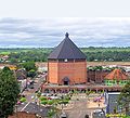 Catedral de Nossa Senhora da Glória, Brazil
 Union Bridge (Portuguese: Ponte da União) in Cruzeiro do Sul runs to the state capital Rio Branco, through the BR-364, Brazil

 Juruá Hospital


.jpg)


References
External links
- (in Portuguese) Bem-vindo à Cruzeiro do Sul