
Size of this preview: 800 × 599 pixels. Other resolutions: 320 × 240 pixels | 640 × 479 pixels | 1,024 × 767 pixels.
Original file (1,024 × 767 pixels, file size: 155 KB, MIME type: image/jpeg)
Summary
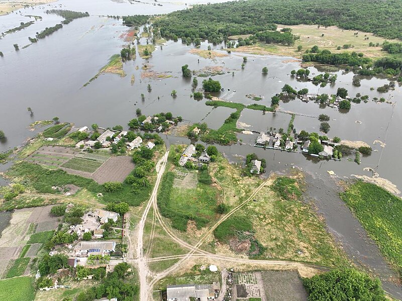
| Description | Русский: Наводнение в Херсонской области после разрушения Каховской ГЭС. Село Новогреднево на реке Ингулец (обычно река занимает лишь малую площадь в левом верхнем углу снимка). English: Flood in Kherson Oblast after the destruction of the Kakhovka Dam. The village Novohrednyeve on Inhulets River (usually the river covers only a small area in upper left). Українська: Original description: Миколаївська область: оперативна інформація щодо підтоплення внаслідок підриву Каховської ГЕС Внаслідок руйнування Каховської ГЕС та підняття рівня води в руслі р. Дніпро сталося підняття рівня Бузького лиману, р. Південний Буг, р. Інгул, р. Інгулець та р. Висунь, внаслідок чого частково підтоплено 31 населений пункт (підтоплено 540 будівель, 856 городів, 549 господарств). Повністю відрізані під'їзди до с. Афанасівка Снігурівської ТГ, де проживає 379 мешканців. |
| Date | |
| Source | https://www.facebook.com/photo/?fbid=653160106851882&set=pcb.653153946852498 (the whole post) |
| Author | State Emergency Service of Ukraine |
| Object location | | View this and other nearby images on: OpenStreetMap |
|---|
Licensing
This file is licensed under the Creative Commons Attribution 4.0 International license.
Attribution: Dsns.gov.ua
- You are free:
- to share – to copy, distribute and transmit the work
- to remix – to adapt the work
- Under the following conditions:
- attribution – You must give appropriate credit, provide a link to the license, and indicate if changes were made. You may do so in any reasonable manner, but not in any way that suggests the licensor endorses you or your use.
File history
Click on a date/time to view the file as it appeared at that time.
| Date/Time | Thumbnail | Dimensions | User | Comment | |
|---|---|---|---|---|---|
| current | 23:04, 11 June 2023 | | 1,024 × 767 (155 KB) | Sneeuwschaap | Uploaded a work by State Emergency Service of Ukraine from https://www.facebook.com/photo/?fbid=653160106851882&set=pcb.653153946852498 ([https://www.facebook.com/MNS.GOV.UA/posts/pfbid0F5J1WXqTWJScPTx6Z7AhnAGiVrho5r9XXZeHMti1wZf3Pgd3HpnWP5tDYam91eZSl the whole post]) with UploadWizard |
File usage
The following pages on the English Wikipedia use this file (pages on other projects are not listed):
Global file usage
The following other wikis use this file:
- Usage on ce.wikipedia.org
- Usage on es.wikipedia.org
- Usage on fr.wikipedia.org
- Usage on fr.wiktionary.org
- Usage on ka.wikipedia.org
- Usage on nl.wikipedia.org
- Usage on pl.wikipedia.org
- Usage on ro.wikipedia.org
- Usage on ru.wikipedia.org
- Usage on uk.wikipedia.org
- Usage on www.wikidata.org
- Usage on zh.wikipedia.org
🔥 Top keywords: Main PageSpecial:SearchIndian Premier LeagueWikipedia:Featured picturesPornhubUEFA Champions League2024 Indian Premier LeagueFallout (American TV series)Jontay PorterXXXTentacionAmar Singh ChamkilaFallout (series)Cloud seedingReal Madrid CFCleopatraRama NavamiRichard GaddDeaths in 2024Civil War (film)Shōgun (2024 miniseries)2024 Indian general electionJennifer PanO. J. SimpsonElla PurnellBaby ReindeerCaitlin ClarkLaverne CoxXXX (film series)Facebook2023–24 UEFA Champions LeagueYouTubeCandidates Tournament 2024InstagramList of European Cup and UEFA Champions League finalsJude BellinghamMichael Porter Jr.Andriy LuninCarlo AncelottiBade Miyan Chote Miyan (2024 film)