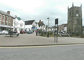
Forest of Dean is a local government district in west Gloucestershire, England, named after the Forest of Dean. Its council is based in Coleford. Other towns and villages in the district include Blakeney, Cinderford, Drybrook, English Bicknor, Huntley, Littledean, Longhope, Lydbrook, Lydney, Mitcheldean, Newnham and Newent.[4][5]
Forest of Dean District | |
|---|---|
 Coleford Market Place, the town where Forest of Dean District Council is based | |
 Forest of Dean shown within Gloucestershire | |
| Sovereign state | United Kingdom |
| Constituent country | England |
| Region | South West England |
| Non-metropolitan county | Gloucestershire |
| Status | Non-metropolitan district |
| Admin HQ | Coleford |
| Incorporated | 1 April 1974 |
| Government | |
| • Type | Non-metropolitan district council |
| • Body | Forest of Dean District Council |
| • Leadership | Leader & Cabinet |
| • MPs | Mark Harper |
| Area | |
| • Total | 203.2 sq mi (526.4 km2) |
| • Rank | 75th (of 296) |
| Population (2022) | |
| • Total | 87,937 |
| • Rank | 270th (of 296) |
| • Density | 430/sq mi (170/km2) |
| Ethnicity (2021) | |
| • Ethnic groups | |
| Religion (2021) | |
| • Religion | List
|
| Time zone | UTC0 (GMT) |
| • Summer (DST) | UTC+1 (BST) |
| ONS code | 23UD (ONS) E07000080 (GSS) |
| OS grid reference | SO6206309601 |
Forest of Dean District Council | |
|---|---|
 | |
| Type | |
| Type | |
| Leadership | |
Andrew Grant since January 2023[2] | |
| Structure | |
| Seats | 38 councillors[3] |
 | |
Political groups |
|
| Elections | |
| First past the post | |
Last election | 4 May 2023 |
Next election | 2027 |
| Meeting place | |
 | |
| Council Offices, High Street, Coleford, GL16 8HG | |
| Website | |
| www | |
History
The district was formed on 1 April 1974 under the Local Government Act 1972. The new district covered the whole area of four former districts and part of a fifth, which were all abolished at the same time:[6][7]
- East Dean Rural District
- Gloucester Rural District (parishes of Newnham and Westbury-on-Severn only)
- Lydney Rural District
- Newent Rural District
- West Dean Rural District
The new district was named Forest of Dean after the ancient woodland which covers much of the district.[8]
Governance
Forest of Dean District Council provides district-level services. County-level services are provided by Gloucestershire County Council.[9] The whole district is also covered by civil parishes, which form a third tier of local government.[10]
Political control
Since the 2023 election the council has been run by a Green minority administration with support from Labour on a confidence and supply basis.[11]
The first election to the council was held in 1973, initially operating as a shadow authority alongside the outgoing authorities until the new arrangements came into effect on 1 April 1974. Political control of the council since 1974 has been as follows:[12][13]
| Party in control | Years | |
|---|---|---|
| Independent | 1974–1976 | |
| No overall control | 1976–1991 | |
| Labour | 1991–2003 | |
| No overall control | 2003–present | |
Leadership
The leaders of the council since 2007 have been:[14]
| Councillor | Party | From | To | |
|---|---|---|---|---|
| Marion Winship | Conservative | 23 May 2007 | Sep 2009 | |
| Peter Amos | Conservative | 11 Sep 2009 | 8 May 2011 | |
| Patrick Molyneux | Conservative | 26 May 2011 | 13 Jul 2017 | |
| Tim Gwilliam | Independent | 13 Jul 2017 | 25 May 2023 | |
| Mark Topping[15] | Green | 25 May 2023 | 18 Apr 2024 | |
| Adrian Birch[16] | Green | 18 April 2024 | ||
Composition
Following the 2023 election, the composition of the council was:[17]
| Party | Councillors | |
|---|---|---|
| Green | 15 | |
| Independent | 11 | |
| Labour | 5 | |
| Conservative | 4 | |
| Liberal Democrats | 3 | |
| Total | 38 | |
The next election is due in 2027.
Premises
The council is based at the Council Offices on High Street in Coleford.[18]
Elections
Since the last boundary changes in 2019, the council has comprised 38 councillors elected from 21 wards, with each ward electing one, two or three councillors. Elections are held every four years.[19]
Parishes and settlements
The whole district is divided into civil parishes. The parish councils of Cinderford, Coleford, Lydney and Newent take the style "town council".[20]
Settlements include:
- Alvington, Awre, Aylburton
- Blaisdon, Birdwood, Bream, Brockweir, Bromsberrow, Blakeney
- Churcham, Cinderford, Coleford
- Drybrook, Dymock
- Ellwood, English Bicknor
- Gorsley and Kilcot
- Hartpury, Hewelsfield, Highleadon, Huntley
- Kempley
- Littledean, Little London, Longhope, Lydbrook, Lydney
- May Hill, Mitcheldean
- Newent, Newland, Newnham
- Oxenhall
- Pauntley, Parkend
- Redmarley D'Abitot, Ruardean, Rudford, Ruspidge
- Soudley, St. Briavels, Staunton (near Coleford), Symonds Yat
- Taynton, Tibberton, Tidenham
- Upleadon
- Westbury-on-Severn, West Dean, Woolaston