The Irazú Volcano (Spanish: Volcán Irazú) is an active volcano in Costa Rica, situated in the Cordillera Central close to the city of Cartago.
| Irazú Volcano | |
|---|---|
 Irazú Crater | |
| Highest point | |
| Elevation | 3,432 m (11,260 ft)[1] |
| Prominence | 1,872 m (6,142 ft) |
| Coordinates | 9°58′45″N 83°51′09″W / 9.97917°N 83.85250°W[1] |
| Geography | |
 Irazú Volcano | |
| Parent range | Cordillera Central |
| Geology | |
| Mountain type | Complex Stratovolcano |
| Last eruption | December 1994[1] |
The name might have come from either the combination of "ara" (point) and "tzu" (thunder)[clarification needed] or a corruption of Iztarú, which was the name of an indigenous village on the flanks of the volcano. In Costa Rica it is known by the name of "El Coloso" (the Colossus) due to the catastrophes that it has unleashed in the past.
The volcano's summit has several craters, one of which contains Diego de la Haya, a green crater lake of variable depth. At 11,260 feet (3,432 m), the Irazú Volcano is the highest active volcano in Costa Rica.[2] It is thus a popular tourist spot. It is easily visited from San José, the Costa Rican capital, with a road leading right up to the summit craters and a weekly bus service to the top. The summit of the volcano also houses a few television transmitters for television stations in San José.
From the top it is possible to see both the Atlantic and Pacific oceans on a clear day.[3] However, such clear days are rare, and the volcano's summit is usually cloud-covered.
The volcano is contained within the Irazú Volcano National Park, which spreads across 5,705 acres (2,300 ha). The national park contains both primary and secondary montane forests and is home to armadillos, owls, rabbits, foxes, woodpeckers, and hummingbirds.[4]
Geology
The Irazú volcano is a complex volcanic shield. It is the highest active volcano in Costa Rica, and has an area of 500 km2 (190 sq mi). It has an irregular subconic shape, and temperatures at its summit vary between 3 and 17 °C (37 and 63 °F), with a record low of −3 °C(26.6 °F) [5] and a record high of 23.2 °C(73.4 °F).[6] Irazu volcano is a stratovolcano with a summit elevation of 3,432 metres (11,260 ft). Its five craters are easily differentiated.[1] The most important ones, because of their activity, are The Main Crater and the Diego de la Haya crater. The Main Crater is almost circular, has very inclined walls and it measures 1,050 metres (3,440 ft) in diameter and 300 metres (980 ft) deep. The Diego de la Haya crater is 600 metres (2,000 ft) in diameter and 100 metres (330 ft) deep. Other craters are Playa Hermosa, La Laguna, and El Piroclastico.[7]
Irazú is the southernmost of the ten Quaternary volcanoes which form a northwest-trending line through central and northern Costa Rica.[3] Radioactive dating has shown an age of at least 854,000 years with eruption peaks at 570,000 years and the most recent active phase from 136,000 years to present. The most recent activity includes lava flows along with strombolian and phreatomagmatic explosions.[3] Lava types include basalt and andesite erupted during different events suggesting the volcano is fed by two distinct magma chambers.[3] Scientists believed that pulses of magma mixed together in the chamber before climbing upward—a process estimated to take several thousands of years. But Columbia University volcanologists found that the eruption of Costa Rica's Irazu volcano in 1963 was likely triggered by magma that took a nonstop route from the mantle over just a few months. Study authors called it the highway from hell.[8]


Eruptive history

Irazú has erupted frequently in historical times — at least 23 times since its first historically recorded [9] eruption in 1723. Its most famous eruption began in mid-March 1963, a few days before US President John F. Kennedy started a state visit to Costa Rica.[10] It showered the capital San José and much of the central highlands of Costa Rica with ash.[11] Eruptions continued for two years.[12]
Its historical eruptions generally have VEIs of 1 to 3. All historical eruptions have been explosive, and there have been many phreatic eruptions, and some have produced pyroclastic flows. The latest eruption lasted only 1 day, and occurred on December 8, 1994. It occurred at a flank vent and was a phreatic eruption, which produced lahars.[9]
Climate
| Climate data for Volcán Irazú, Costa Rica (2005–2018) | |||||||||||||
|---|---|---|---|---|---|---|---|---|---|---|---|---|---|
| Month | Jan | Feb | Mar | Apr | May | Jun | Jul | Aug | Sep | Oct | Nov | Dec | Year |
| Mean daily maximum °C (°F) | 12.6 (54.7) | 14.2 (57.6) | 15.8 (60.4) | 16.4 (61.5) | 15.4 (59.7) | 14.2 (57.6) | 12.3 (54.1) | 13.2 (55.8) | 14.4 (57.9) | 14.3 (57.7) | 12.8 (55.0) | 12.1 (53.8) | 14.0 (57.2) |
| Daily mean °C (°F) | 8.3 (46.9) | 9.3 (48.7) | 10.4 (50.7) | 11.1 (52.0) | 10.8 (51.4) | 10.2 (50.4) | 8.9 (48.0) | 9.4 (48.9) | 10.1 (50.2) | 10.1 (50.2) | 9.1 (48.4) | 8.3 (46.9) | 9.7 (49.4) |
| Mean daily minimum °C (°F) | 4.0 (39.2) | 4.3 (39.7) | 4.9 (40.8) | 5.7 (42.3) | 6.2 (43.2) | 6.2 (43.2) | 5.5 (41.9) | 5.6 (42.1) | 5.8 (42.4) | 5.8 (42.4) | 5.4 (41.7) | 4.4 (39.9) | 5.3 (41.6) |
| Average rainfall mm (inches) | 110.4 (4.35) | 57.4 (2.26) | 35.2 (1.39) | 54.1 (2.13) | 181.2 (7.13) | 166.4 (6.55) | 177.3 (6.98) | 139.9 (5.51) | 201.7 (7.94) | 268.0 (10.55) | 300.1 (11.81) | 173.0 (6.81) | 1,864.7 (73.41) |
| Average rainy days | 17 | 12 | 12 | 15 | 23 | 23 | 24 | 23 | 25 | 28 | 24 | 22 | 248 |
| Average relative humidity (%) | 73 | 64 | 62 | 73 | 83 | 89 | 91 | 89 | 89 | 90 | 89 | 81 | 81 |
| Source: Instituto Meteorológico Nacional[13] | |||||||||||||
Gallery
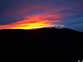 Sunset from the summit
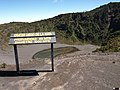 Top view of Diego de la Haya
 Sunset at Diego de la Haya crater
 Main crater lagoon
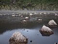 Inside Diego de la Haya
 Playa Hermosa extinct crater
 Playa Hermosa extinct crater
 Diego de la Haya crater
 Diego de la Haya lagoon
 Great crater wall
 Distant wide view of Irazu volcano
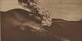 1918 eruption
 1963 eruption from San José
 1963 eruption
 1963 eruption


_-_Daniel_Vargas.jpg)


